Property Record
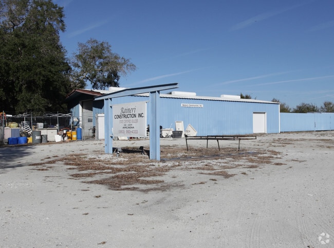
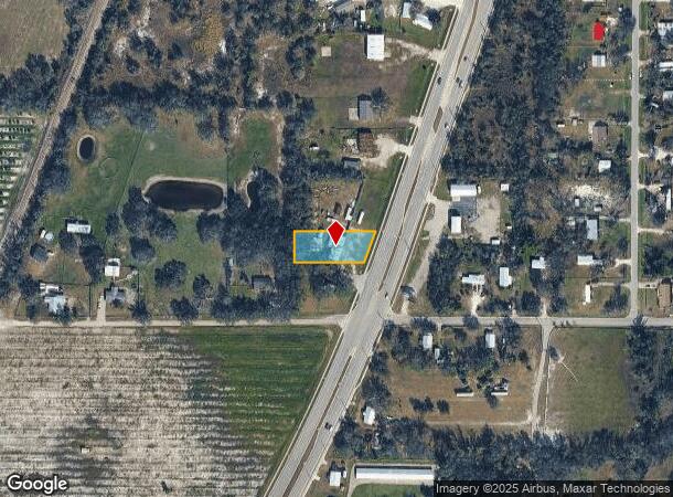
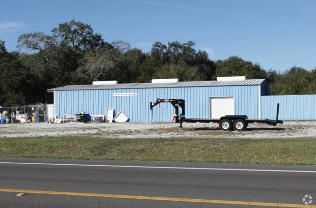
3463 Sw Highway 17, Arcadia, FL 34266
This Property Is For Sale
NEARBY LISTINGS FOR SALE OR LEASE
-
-
View all Arcadia listings for sale on LoopNet.com
Property Detail
3463 Sw Highway 17
Arcadia, FL
Mcleod Subdivison
13-38-24-0419-0000-0020
MCLEOD SUB LOT 2 OR 271/291 INST:202214002886 INST:202214002887 INST:202214002888 INST:202214002889 INST:202214005876
Warehouse
DeSoto
X
Florida
12027C0167C
2
2024
0.56 AC
2024
Florida Central South Area
010302
Other Market Areas
2,658 SF
DEMOGRAPHICS near 3463 Sw Highway 17
1 Mile
3 Mile
5 Mile
2024 Total Population
974
11,387
23,504
2029 Population
1,089
12,629
25,954
Pop Growth 2024-2029
+ 11.81%
+ 10.91%
+ 10.42%
Average Age
35
37
39
2024 Total Households
314
3,930
8,069
HH Growth 2024-2029
+ 12.74%
+ 11.81%
+ 11.41%
Median Household Inc
$38,333
$33,765
$34,542
Avg Household Size
3.10
2.90
2.80
2024 Avg HH Vehicles
2.00
2.00
2.00
Median Home Value
$91,236
$99,608
$116,816
Median Year Built
1980
1983
1984
Nearby Places
Map Layers
Map Styles
 Street
 Aerial
- Restaurants
- Banks
- Shops
- Fitness
- Groceries
PUBLIC TRANSPORTATION
AIRPORT
Punta Gorda
DRIVE
WALK
Distance
Punta Gorda
32 min
22.1 mi
Freight Ports
Port Manatee
DRIVE
WALK
Distance
Port Manatee
84 min
61.0 mi
Nearby Properties
Address
Land Use
TOTAL SIZE
Lot Size
Zoning
Address
Land Use
TOTAL SIZE
Lot Size
Zoning
67,387 SF
46.10 AC
PUD
Address
Land Use
TOTAL SIZE
Lot Size
Zoning
57,048 SF
20.25 AC
PUD
Address
Land Use
TOTAL SIZE
Lot Size
Zoning
83,273 SF
13.94 AC
ROI
Address
Land Use
TOTAL SIZE
Lot Size
Zoning
40,614 SF
4.33 AC
R-3
Address
Land Use
TOTAL SIZE
Lot Size
Zoning
41,004 SF
4.67 AC
R-3
Address
Land Use
TOTAL SIZE
Lot Size
Zoning
21,108 SF
3.36 AC
A-5
Address
Land Use
TOTAL SIZE
Lot Size
Zoning
20,008 SF
4.69 AC
A-5
Address
Land Use
TOTAL SIZE
Lot Size
Zoning
59,064 SF
7 AC
RSF-3
Address
Land Use
TOTAL SIZE
Lot Size
Zoning
66,888 SF
11.95 AC
RMF-12
Address
Land Use
TOTAL SIZE
Lot Size
Zoning
1,368 SF
16.90 AC
MHP
Address
Land Use
TOTAL SIZE
Lot Size
Zoning
Address
Land Use
TOTAL SIZE
Lot Size
Zoning
42,314 SF
120 AC
IL
Address
Land Use
TOTAL SIZE
Lot Size
Zoning
3,200 SF
49.29 AC
RMF-M
Address
Land Use
TOTAL SIZE
Lot Size
Zoning
20,672 SF
3.67 AC
M-1
Address
Land Use
TOTAL SIZE
Lot Size
Zoning
166,805 SF
11.56 AC
M-2
Address
Land Use
TOTAL SIZE
Lot Size
Zoning
10,972 SF
6.77 AC
RSF-3
Address
Land Use
TOTAL SIZE
Lot Size
Zoning
22,414 SF
5.02 AC
R-1C
Address
Land Use
TOTAL SIZE
Lot Size
Zoning
50,951 SF
47.23 AC
IH
Address
Land Use
TOTAL SIZE
Lot Size
Zoning
47,950 SF
5.66 AC
IL
Address
Land Use
TOTAL SIZE
Lot Size
Zoning
12,152 SF
1.56 AC
B-3
Address
Land Use
TOTAL SIZE
Lot Size
Zoning
9,499 SF
0.58 AC
B-1
Address
Land Use
TOTAL SIZE
Lot Size
Zoning
96 SF
95.92 AC
A-10
Address
Land Use
TOTAL SIZE
Lot Size
Zoning
7,307 SF
305.60 AC
A-5
Address
Land Use
TOTAL SIZE
Lot Size
Zoning
44,436 SF
3.94 AC
B-3
Address
Land Use
TOTAL SIZE
Lot Size
Zoning
1,800 SF
13.92 AC
MHP
Address
Land Use
TOTAL SIZE
Lot Size
Zoning
7,895 SF
2.47 AC
CG
Address
Land Use
TOTAL SIZE
Lot Size
Zoning
82.54 AC
A-10
Address
Land Use
TOTAL SIZE
Lot Size
Zoning
5,973 SF
1.04 AC
B-3
Address
Land Use
TOTAL SIZE
Lot Size
Zoning
104.70 AC
IL
Address
Land Use
TOTAL SIZE
Lot Size
Zoning
23,281 SF
2.07 AC
R-3
The World's #1 Commercial Real Estate Marketplace
Connect with us
© 2025 CoStar Group
The information above has been obtained from sources believed reliable. While we do not doubt its accuracy we have not verified it and make no guarantee, warranty or representation about it. It is your responsibility to independently confirm its accuracy and completeness. Any projections, opinions, assumptions, or estimates used are for example only and do not represent the current or future performance of the property. The value of this transaction to you depends on tax and other factors which should be evaluated by your tax, financial, and legal advisors. You and your advisors should conduct a careful, independent investigation of the property to determine to your satisfaction the suitability of the property for your needs.