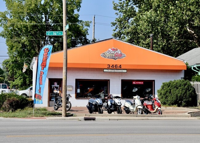
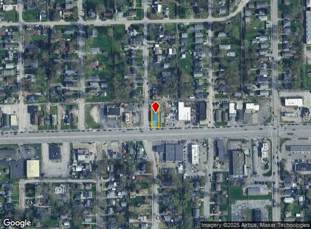
Property Record
3464 W 16Th St, Indianapolis, IN 46222
NEARBY LISTINGS FOR SALE OR LEASE
Property Detail
3464 W 16Th St
Indianapolis-Carmel-Anderson, IN
Rainbow Ridge
49-06-32-115-598.000-901
RAINBOW RIDGE L183
Storebuilding
Marion
X
Indiana
18097C0137G
183
2023
0.14 AC
2024
Speedway
340700
Indianapolis
3,072 SF
DEMOGRAPHICS near 3464 W 16Th St
1 Mile
3 Mile
5 Mile
2024 Total Population
14,273
105,278
268,087
2029 Population
14,305
105,806
268,122
Pop Growth 2024-2029
+ 0.22%
+ 0.50%
+ 0.01%
Average Age
35
35
35
2024 Total Households
5,273
41,530
111,854
HH Growth 2024-2029
+ 0.13%
+ 0.61%
+ 0.11%
Median Household Inc
$44,369
$47,524
$53,180
Avg Household Size
2.60
2.40
2.30
2024 Avg HH Vehicles
2.00
2.00
2.00
Median Home Value
$74,813
$114,612
$166,461
Median Year Built
1951
1961
1966
Nearby Places
Map Layers
Map Styles
 Street
 Aerial
- Restaurants
- Banks
- Shops
- Fitness
- Groceries
PUBLIC TRANSPORTATION
COMMUTER RAIL
DRIVE
WALK
Distance
10 min
4.8 mi
AIRPORT
Indianapolis International
DRIVE
WALK
Distance
Indianapolis International
24 min
12.0 mi
SALE & LEASE HISTORY
LISTING DATE
SALE/LEASE

Oct 09, 2024
For Sale
Nearby Properties
Address
Land Use
TOTAL SIZE
Lot Size
Zoning
Address
Land Use
TOTAL SIZE
Lot Size
Zoning
19,176 SF
28.36 AC
ZO01
Address
Land Use
TOTAL SIZE
Lot Size
Zoning
80,249 SF
71.96 AC
ZO01
Address
Land Use
TOTAL SIZE
Lot Size
Zoning
5,280 SF
97.87 AC
ZO01
Address
Land Use
TOTAL SIZE
Lot Size
Zoning
176,017 SF
3.92 AC
ZO01
Address
Land Use
TOTAL SIZE
Lot Size
Zoning
271,411 SF
3 AC
ZO01
Address
Land Use
TOTAL SIZE
Lot Size
Zoning
1,260 SF
3.92 AC
ZO01
Address
Land Use
TOTAL SIZE
Lot Size
Zoning
3,013 SF
10.80 AC
ZO01
Address
Land Use
TOTAL SIZE
Lot Size
Zoning
700 SF
1.50 AC
ZO01
Address
Land Use
TOTAL SIZE
Lot Size
Zoning
11,150 SF
3.24 AC
ZO01
Address
Land Use
TOTAL SIZE
Lot Size
Zoning
415,877 SF
55.83 AC
ZO01
Address
Land Use
TOTAL SIZE
Lot Size
Zoning
25,170 SF
0.65 AC
ZO01
Address
Land Use
TOTAL SIZE
Lot Size
Zoning
1,889,477 SF
89.82 AC
ZO01
Address
Land Use
TOTAL SIZE
Lot Size
Zoning
132 SF
3.26 AC
ZO01
Address
Land Use
TOTAL SIZE
Lot Size
Zoning
94,784 SF
4.31 AC
Address
Land Use
TOTAL SIZE
Lot Size
Zoning
60,400 SF
4.41 AC
ZO01
Address
Land Use
TOTAL SIZE
Lot Size
Zoning
69,380 SF
4.45 AC
ZO01
Address
Land Use
TOTAL SIZE
Lot Size
Zoning
4,663 SF
7.98 AC
ZO01
Address
Land Use
TOTAL SIZE
Lot Size
Zoning
600,000 SF
41.64 AC
ZO01
Address
Land Use
TOTAL SIZE
Lot Size
Zoning
3,546 SF
25.09 AC
ZO01
Address
Land Use
TOTAL SIZE
Lot Size
Zoning
18,154 SF
9.40 AC
ZO01
Address
Land Use
TOTAL SIZE
Lot Size
Zoning
3,878 SF
17.76 AC
Address
Land Use
TOTAL SIZE
Lot Size
Zoning
85,414 SF
10.10 AC
Address
Land Use
TOTAL SIZE
Lot Size
Zoning
2,288 SF
6 AC
ZO01
Address
Land Use
TOTAL SIZE
Lot Size
Zoning
438,643 SF
43.63 AC
ZO01
Address
Land Use
TOTAL SIZE
Lot Size
Zoning
70,717 SF
7.40 AC
ZO01
Address
Land Use
TOTAL SIZE
Lot Size
Zoning
163,712 SF
1.02 AC
ZO01
Address
Land Use
TOTAL SIZE
Lot Size
Zoning
19,930 SF
3.92 AC
ZO01
Address
Land Use
TOTAL SIZE
Lot Size
Zoning
3,618 SF
31.13 AC
ZO01
Address
Land Use
TOTAL SIZE
Lot Size
Zoning
3,706 SF
30.57 AC
ZO01
Address
Land Use
TOTAL SIZE
Lot Size
Zoning
1.88 AC
ZO01
The World's #1 Commercial Real Estate Marketplace
Connect with us
© 2025 CoStar Group
The information above has been obtained from sources believed reliable. While we do not doubt its accuracy we have not verified it and make no guarantee, warranty or representation about it. It is your responsibility to independently confirm its accuracy and completeness. Any projections, opinions, assumptions, or estimates used are for example only and do not represent the current or future performance of the property. The value of this transaction to you depends on tax and other factors which should be evaluated by your tax, financial, and legal advisors. You and your advisors should conduct a careful, independent investigation of the property to determine to your satisfaction the suitability of the property for your needs.