Property Record
3465 Susie Ln, Gilroy, CA 95020
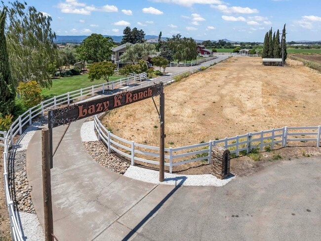

Property Detail
3465 Susie Ln
San Jose-Sunnyvale-Santa Clara, CA
LOT B
841-44-042
Santa Clara
Orchard
California
AW
b
D Areas with possible but undetermined flood hazards.
11.54 AC
2024
Outlying Santa Clara Cnty
2025
South Bay/San Jose
512602
NEARBY LISTINGS FOR SALE OR LEASE
DEMOGRAPHICS near 3465 Susie Ln
1 mile
3 mile
5 mile
2025 Total Population
281
3,164
49,884
2030 Population
270
3,152
50,806
Pop Growth 2025-2030
(3.91%)
(0.38%)
+ 1.85%
Average Age
44
38
38
2025 Total Households
88
884
14,354
HH Growth 2025-2030
(3.41%)
(0.79%)
+ 1.82%
Median Household Inc
$166,666
$123,437
$115,931
Avg Household Size
3.10
3.40
3.30
2025 Avg HH Vehicles
3.00
3.00
2.00
Median Home Value
$1,054,167
$972,221
$878,685
Median Year Built
1974
1975
1982
Nearby Places
Map Layers
Map Styles
 Street
 Aerial
Layers
 Traffic
 Biking
Places
Listings with unknown addresses are not visible on the map
- Restaurants
- Banks
- Shops
- Fitness
- Groceries
PUBLIC TRANSPORTATION
COMMUTER RAIL
Drive
Walk
Distance
10 min
4.7 mi
AIRPORT
Norman Y Mineta San Jose International
Drive
Walk
Distance
Norman Y Mineta San Jose International
51 min
39.2 mi
Monterey Regional
Drive
Walk
Distance
Monterey Regional
57 min
44.1 mi
Freight Ports
Port of Redwood City
Drive
Walk
Distance
Port of Redwood City
73 min
57.3 mi
SALE & LEASE HISTORY
LISTING DATE
SALE/LEASE

Jul 01, 2025
For Sale
Nearby Properties
Address
Land Use
TOTAL SIZE
Lot Size
Zoning
Address
Land Use
TOTAL SIZE
Lot Size
Zoning
921,750 SF
40.33 AC
M2
Address
Land Use
TOTAL SIZE
Lot Size
Zoning
133,498 SF
12.16 AC
C3
Address
Land Use
TOTAL SIZE
Lot Size
Zoning
11.04 AC
M2
Address
Land Use
TOTAL SIZE
Lot Size
Zoning
9.90 AC
M2
Address
Land Use
TOTAL SIZE
Lot Size
Zoning
219,622 SF
19.80 AC
A1-25
Address
Land Use
TOTAL SIZE
Lot Size
Zoning
56.33 AC
M2
Address
Land Use
TOTAL SIZE
Lot Size
Zoning
59.87 AC
M2
Address
Land Use
TOTAL SIZE
Lot Size
Zoning
148,663 SF
14.79 AC
PUD
Address
Land Use
TOTAL SIZE
Lot Size
Zoning
4,853 SF
11.59 AC
HC
Address
Land Use
TOTAL SIZE
Lot Size
Zoning
63,560 SF
7.63 AC
A1-25
Address
Land Use
TOTAL SIZE
Lot Size
Zoning
123,709 SF
9.26 AC
M2
Address
Land Use
TOTAL SIZE
Lot Size
Zoning
56,020 SF
2.61 AC
M2
Address
Land Use
TOTAL SIZE
Lot Size
Zoning
146,682 SF
11.83 AC
A1-25
Address
Land Use
TOTAL SIZE
Lot Size
Zoning
5.52 AC
M2
Address
Land Use
TOTAL SIZE
Lot Size
Zoning
88,408 SF
7.63 AC
PUD
Address
Land Use
TOTAL SIZE
Lot Size
Zoning
120,665 SF
6.25 AC
M2
Address
Land Use
TOTAL SIZE
Lot Size
Zoning
6.02 AC
M2
Address
Land Use
TOTAL SIZE
Lot Size
Zoning
125,597 SF
13.70 AC
C3
Address
Land Use
TOTAL SIZE
Lot Size
Zoning
107,824 SF
12.20 AC
PUD
Address
Land Use
TOTAL SIZE
Lot Size
Zoning
62,360 SF
4.50 AC
M2
Address
Land Use
TOTAL SIZE
Lot Size
Zoning
8.68 AC
M2
Address
Land Use
TOTAL SIZE
Lot Size
Zoning
285,686 SF
19.99 AC
M2
Address
Land Use
TOTAL SIZE
Lot Size
Zoning
33,569 SF
2.26 AC
M1
Address
Land Use
TOTAL SIZE
Lot Size
Zoning
62,400 SF
2.57 AC
M2
Address
Land Use
TOTAL SIZE
Lot Size
Zoning
70,716 SF
5.15 AC
M2
Address
Land Use
TOTAL SIZE
Lot Size
Zoning
39,342 SF
3.51 AC
M2
Address
Land Use
TOTAL SIZE
Lot Size
Zoning
15,000 SF
2.39 AC
A1-25
Address
Land Use
TOTAL SIZE
Lot Size
Zoning
1,248 SF
10.23 AC
M2
The World's #1 Commercial Real Estate Marketplace
Connect with us
© 2026 CoStar Group
The information above has been obtained from sources believed reliable. While we do not doubt its accuracy we have not verified it and make no guarantee, warranty or representation about it. It is your responsibility to independently confirm its accuracy and completeness. Any projections, opinions, assumptions, or estimates used are for example only and do not represent the current or future performance of the property. The value of this transaction to you depends on tax and other factors which should be evaluated by your tax, financial, and legal advisors. You and your advisors should conduct a careful, independent investigation of the property to determine to your satisfaction the suitability of the property for your needs.