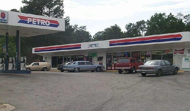
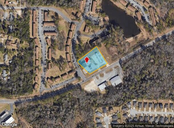
Property Record
3465 Williamson Rd, Macon, GA 31206
NEARBY LISTINGS FOR SALE OR LEASE
Property Detail
3465 Williamson Rd
Conveniencestore
Bibb
X
Georgia
13021C0137G
1.44 AC
2025
Suburban Macon
2025
Atlanta
012600
Macon-Bibb County, GA
4,100 SF
M094-0163
DEMOGRAPHICS near 3465 Williamson Rd
1 mile
3 mile
5 mile
2024 Total Population
5,139
44,079
86,140
2029 Population
5,123
44,275
86,068
Pop Growth 2024-2029
(0.31%)
+ 0.44%
(0.08%)
Average Age
36
36
37
2024 Total Households
1,841
16,634
34,092
HH Growth 2024-2029
(0.33%)
+ 0.36%
(0.03%)
Median Household Inc
$34,172
$31,424
$39,016
Avg Household Size
2.60
2.50
2.40
2024 Avg HH Vehicles
2.00
1.00
1.00
Median Home Value
$92,583
$71,328
$126,961
Median Year Built
1971
1967
1969
Nearby Places
Map Layers
Map Styles
 Street
 Aerial
Transit
 Traffic
 Biking
Places
Listings with unknown addresses are not visible on the map
- Restaurants
- Banks
- Shops
- Fitness
- Groceries
SALE & LEASE HISTORY
LISTING DATE
SALE/LEASE

Aug 23, 2018
For Lease
Nearby Properties
Address
Land Use
TOTAL SIZE
Lot Size
Zoning
Address
Land Use
TOTAL SIZE
Lot Size
Zoning
17,812 SF
161.34 AC
A/C-4
Address
Land Use
TOTAL SIZE
Lot Size
Zoning
181,396 SF
44.77 AC
R-1A
Address
Land Use
TOTAL SIZE
Lot Size
Zoning
18,900 SF
25.25 AC
C-2
Address
Land Use
TOTAL SIZE
Lot Size
Zoning
1,428 SF
64.46 AC
R-1A
Address
Land Use
TOTAL SIZE
Lot Size
Zoning
86,912 SF
5.39 AC
PDE
Address
Land Use
TOTAL SIZE
Lot Size
Zoning
89,814 SF
16.60 AC
R-1A
Address
Land Use
TOTAL SIZE
Lot Size
Zoning
3,139 SF
240.10 AC
A
Address
Land Use
TOTAL SIZE
Lot Size
Zoning
98,928 SF
12.32 AC
R-3
Address
Land Use
TOTAL SIZE
Lot Size
Zoning
85,556 SF
10.50 AC
R-1A
Address
Land Use
TOTAL SIZE
Lot Size
Zoning
110,153 SF
22 AC
R-2
Address
Land Use
TOTAL SIZE
Lot Size
Zoning
2,766 SF
10.96 AC
R-3
Address
Land Use
TOTAL SIZE
Lot Size
Zoning
46,288 SF
1.80 AC
PDE
Address
Land Use
TOTAL SIZE
Lot Size
Zoning
3,268 SF
9.29 AC
R-3
Address
Land Use
TOTAL SIZE
Lot Size
Zoning
202,057 SF
33.05 AC
C-4
Address
Land Use
TOTAL SIZE
Lot Size
Zoning
40,560 SF
19.20 AC
R-2
Address
Land Use
TOTAL SIZE
Lot Size
Zoning
96,512 SF
11.30 AC
PDE
Address
Land Use
TOTAL SIZE
Lot Size
Zoning
58,730 SF
3.42 AC
R-3
Address
Land Use
TOTAL SIZE
Lot Size
Zoning
3,860 SF
22 AC
PDE
Address
Land Use
TOTAL SIZE
Lot Size
Zoning
28,755 SF
70 AC
PDE
Address
Land Use
TOTAL SIZE
Lot Size
Zoning
6,560 SF
17 AC
PDE
Address
Land Use
TOTAL SIZE
Lot Size
Zoning
133,862 SF
25.44 AC
C-2
Address
Land Use
TOTAL SIZE
Lot Size
Zoning
69,184 SF
12.67 AC
C-2
Address
Land Use
TOTAL SIZE
Lot Size
Zoning
108,418 SF
24.45 AC
R-1A
Address
Land Use
TOTAL SIZE
Lot Size
Zoning
105,247 SF
12.27 AC
C-2
Address
Land Use
TOTAL SIZE
Lot Size
Zoning
44,323 SF
2.76 AC
PDE
Address
Land Use
TOTAL SIZE
Lot Size
Zoning
132,423 SF
20.38 AC
C-2
Address
Land Use
TOTAL SIZE
Lot Size
Zoning
20,572 SF
16.08 AC
R-3
Address
Land Use
TOTAL SIZE
Lot Size
Zoning
32,300 SF
24.40 AC
R-2
Address
Land Use
TOTAL SIZE
Lot Size
Zoning
174,764 SF
Address
Land Use
TOTAL SIZE
Lot Size
Zoning
100,192 SF
30.29 AC
C-2
The World's #1 Commercial Real Estate Marketplace
Connect with us
© 2026 CoStar Group
The information above has been obtained from sources believed reliable. While we do not doubt its accuracy we have not verified it and make no guarantee, warranty or representation about it. It is your responsibility to independently confirm its accuracy and completeness. Any projections, opinions, assumptions, or estimates used are for example only and do not represent the current or future performance of the property. The value of this transaction to you depends on tax and other factors which should be evaluated by your tax, financial, and legal advisors. You and your advisors should conduct a careful, independent investigation of the property to determine to your satisfaction the suitability of the property for your needs.