Property Record
3467 County Road 74, Saint Cloud, MN 56301
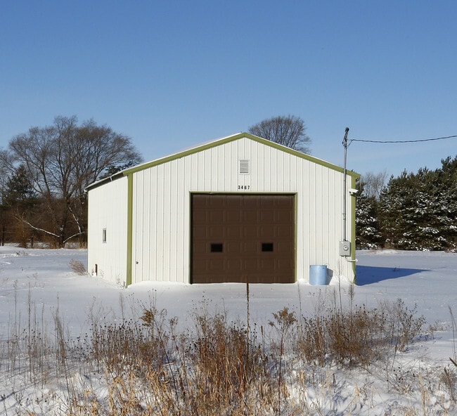


Property Detail
3467 County Road 74
82.44152.0612
6.00A E417.42' OF N626.13' OF SE4NE4 OLD # 30.19087.000 SECTION 32 TOWNSHIP 124 RANGE 028 SECTION 32 TOWNSHIP 124 RANGE 028
Parkingstructure
Stearns
AG
Minnesota
B and X Area of moderate flood hazard, usually the area between the limits of the 100-year and 500-year floods.
6 AC
2026
Stearns County
2025
Minneapolis/St Paul
000401
St. Cloud, MN
NEARBY LISTINGS FOR SALE OR LEASE
DEMOGRAPHICS near 3467 County Road 74
1 mile
3 mile
5 mile
2025 Total Population
432
20,686
75,281
2030 Population
458
21,720
78,291
Pop Growth 2025-2030
+ 6.02%
+ 5.00%
+ 4.00%
Average Age
34
38
37
2025 Total Households
183
8,263
29,441
HH Growth 2025-2030
+ 6.01%
+ 5.00%
+ 4.08%
Median Household Inc
$68,999
$75,909
$65,576
Avg Household Size
2.30
2.40
2.30
2025 Avg HH Vehicles
2.00
2.00
2.00
Median Home Value
$294,230
$329,174
$245,939
Median Year Built
2004
1994
1983
Nearby Places
Map Layers
Map Styles
 Street
 Aerial
Layers
 Traffic
 Biking
Places
Listings with unknown addresses are not visible on the map
- Restaurants
- Banks
- Shops
- Fitness
- Groceries
PUBLIC TRANSPORTATION
COMMUTER RAIL
Drive
Walk
Distance
13 min
6.9 mi
Nearby Properties
Address
Land Use
TOTAL SIZE
Lot Size
Zoning
Address
Land Use
TOTAL SIZE
Lot Size
Zoning
307,404 SF
105.31 AC
Address
Land Use
TOTAL SIZE
Lot Size
Zoning
113,316 SF
31.99 AC
Address
Land Use
TOTAL SIZE
Lot Size
Zoning
125,278 SF
11.01 AC
C5
Address
Land Use
TOTAL SIZE
Lot Size
Zoning
115,298 SF
8.50 AC
R5
Address
Land Use
TOTAL SIZE
Lot Size
Zoning
233,354 SF
7.30 AC
R5
Address
Land Use
TOTAL SIZE
Lot Size
Zoning
19.83 AC
Address
Land Use
TOTAL SIZE
Lot Size
Zoning
146,285 SF
19.10 AC
Address
Land Use
TOTAL SIZE
Lot Size
Zoning
165,878 SF
11.17 AC
PUD56
Address
Land Use
TOTAL SIZE
Lot Size
Zoning
7.70 AC
Address
Land Use
TOTAL SIZE
Lot Size
Zoning
Address
Land Use
TOTAL SIZE
Lot Size
Zoning
158,758 SF
18.58 AC
C5
Address
Land Use
TOTAL SIZE
Lot Size
Zoning
157,351 SF
14.16 AC
C5
Address
Land Use
TOTAL SIZE
Lot Size
Zoning
5.89 AC
Address
Land Use
TOTAL SIZE
Lot Size
Zoning
32,074 SF
7.20 AC
PUD50
Address
Land Use
TOTAL SIZE
Lot Size
Zoning
80,210 SF
4.54 AC
C5
Address
Land Use
TOTAL SIZE
Lot Size
Zoning
4.91 AC
Address
Land Use
TOTAL SIZE
Lot Size
Zoning
20,450 SF
1 AC
Address
Land Use
TOTAL SIZE
Lot Size
Zoning
7.15 AC
Address
Land Use
TOTAL SIZE
Lot Size
Zoning
4.74 AC
Address
Land Use
TOTAL SIZE
Lot Size
Zoning
109,352 SF
77.47 AC
R1
Address
Land Use
TOTAL SIZE
Lot Size
Zoning
68,526 SF
9.80 AC
Address
Land Use
TOTAL SIZE
Lot Size
Zoning
121,968 SF
6.49 AC
PUD84
Address
Land Use
TOTAL SIZE
Lot Size
Zoning
40,360 SF
7.58 AC
Address
Land Use
TOTAL SIZE
Lot Size
Zoning
33,973 SF
6.79 AC
Address
Land Use
TOTAL SIZE
Lot Size
Zoning
307,466 SF
21.87 AC
Address
Land Use
TOTAL SIZE
Lot Size
Zoning
94,048 SF
6.32 AC
Address
Land Use
TOTAL SIZE
Lot Size
Zoning
Address
Land Use
TOTAL SIZE
Lot Size
Zoning
93,501 SF
4.42 AC
R5
Address
Land Use
TOTAL SIZE
Lot Size
Zoning
124,529 SF
6.06 AC
The World's #1 Commercial Real Estate Marketplace
Connect with us
© 2026 CoStar Group
The information above has been obtained from sources believed reliable. While we do not doubt its accuracy we have not verified it and make no guarantee, warranty or representation about it. It is your responsibility to independently confirm its accuracy and completeness. Any projections, opinions, assumptions, or estimates used are for example only and do not represent the current or future performance of the property. The value of this transaction to you depends on tax and other factors which should be evaluated by your tax, financial, and legal advisors. You and your advisors should conduct a careful, independent investigation of the property to determine to your satisfaction the suitability of the property for your needs.