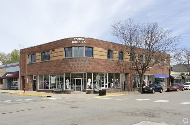
Property Record
347 2Nd St, Excelsior, MN 55331

Property Detail
347 2Nd St
Minneapolis-St. Paul-Bloomington, MN-WI
LOT 028 B AUDITORS SUBD. NO. 135 THAT PART OF LOT 28 LYING ELY OF A LINE RUNNING FROM A PT IN THE SWLY LINE OF LOT 28 DIS 62 FT SELY FROM MOST WLY COR THEREOF TO A PT IN THE T S 70X96X79X96
34-117-23-11-0053
Hennepin
Multifamilydwelling
Minnesota
B and X Area of moderate flood hazard, usually the area between the limits of the 100-year and 500-year floods.
28
2024
0.16 AC
2024
Ridgedale
027501
Minneapolis/St Paul
2,777 SF
NEARBY LISTINGS FOR SALE OR LEASE
DEMOGRAPHICS near 347 2Nd St
1 mile
3 mile
5 mile
2025 Total Population
4,918
32,637
88,981
2030 Population
5,034
33,179
90,079
Pop Growth 2025-2030
+ 2.36%
+ 1.66%
+ 1.23%
Average Age
46
43
43
2025 Total Households
2,156
12,463
34,775
HH Growth 2025-2030
+ 2.32%
+ 1.69%
+ 1.29%
Median Household Inc
$123,943
$151,549
$140,539
Avg Household Size
2.20
2.60
2.50
2025 Avg HH Vehicles
2.00
2.00
2.00
Median Home Value
$854,981
$689,809
$602,918
Median Year Built
1977
1984
1983
Nearby Places
Map Layers
Map Styles
 Street
 Aerial
Layers
 Traffic
 Biking
Places
Listings with unknown addresses are not visible on the map
- Restaurants
- Banks
- Shops
- Fitness
- Groceries
PUBLIC TRANSPORTATION
AIRPORT
Minneapolis-St Paul International/Wold-Chamberlain
Drive
Walk
Distance
Minneapolis-St Paul International/Wold-Chamberlain
31 min
21.1 mi
SALE & LEASE HISTORY
LISTING DATE
SALE/LEASE

Oct 31, 2019
For Lease
Jan 24, 2024
For Lease
Nearby Properties
Address
Land Use
TOTAL SIZE
Lot Size
Zoning
Address
Land Use
TOTAL SIZE
Lot Size
Zoning
4.32 AC
Address
Land Use
TOTAL SIZE
Lot Size
Zoning
55,208 SF
49.75 AC
Address
Land Use
TOTAL SIZE
Lot Size
Zoning
122,807 SF
30.62 AC
Address
Land Use
TOTAL SIZE
Lot Size
Zoning
3,073 SF
155.36 AC
Address
Land Use
TOTAL SIZE
Lot Size
Zoning
3.82 AC
Address
Land Use
TOTAL SIZE
Lot Size
Zoning
1.85 AC
Address
Land Use
TOTAL SIZE
Lot Size
Zoning
21.72 AC
Address
Land Use
TOTAL SIZE
Lot Size
Zoning
7.82 AC
R4
Address
Land Use
TOTAL SIZE
Lot Size
Zoning
17.67 AC
R4
Address
Land Use
TOTAL SIZE
Lot Size
Zoning
9.29 AC
R4
Address
Land Use
TOTAL SIZE
Lot Size
Zoning
14.04 AC
R4
Address
Land Use
TOTAL SIZE
Lot Size
Zoning
16.38 AC
Address
Land Use
TOTAL SIZE
Lot Size
Zoning
1,200 SF
62.14 AC
Address
Land Use
TOTAL SIZE
Lot Size
Zoning
Address
Land Use
TOTAL SIZE
Lot Size
Zoning
1.67 AC
Address
Land Use
TOTAL SIZE
Lot Size
Zoning
6.52 AC
Address
Land Use
TOTAL SIZE
Lot Size
Zoning
3.20 AC
Address
Land Use
TOTAL SIZE
Lot Size
Zoning
5.68 AC
Address
Land Use
TOTAL SIZE
Lot Size
Zoning
5.84 AC
R4
Address
Land Use
TOTAL SIZE
Lot Size
Zoning
16,986 SF
1.77 AC
PUD
Address
Land Use
TOTAL SIZE
Lot Size
Zoning
53,125 SF
3.83 AC
Address
Land Use
TOTAL SIZE
Lot Size
Zoning
2.10 AC
Address
Land Use
TOTAL SIZE
Lot Size
Zoning
Address
Land Use
TOTAL SIZE
Lot Size
Zoning
28,346 SF
2.20 AC
Address
Land Use
TOTAL SIZE
Lot Size
Zoning
5,496 SF
52.15 AC
Address
Land Use
TOTAL SIZE
Lot Size
Zoning
2.60 AC
Address
Land Use
TOTAL SIZE
Lot Size
Zoning
2.54 AC
Address
Land Use
TOTAL SIZE
Lot Size
Zoning
0.91 AC
Address
Land Use
TOTAL SIZE
Lot Size
Zoning
8.08 AC
Address
Land Use
TOTAL SIZE
Lot Size
Zoning
54,451 SF
9.01 AC
The World's #1 Commercial Real Estate Marketplace
Connect with us
© 2026 CoStar Group
The information above has been obtained from sources believed reliable. While we do not doubt its accuracy we have not verified it and make no guarantee, warranty or representation about it. It is your responsibility to independently confirm its accuracy and completeness. Any projections, opinions, assumptions, or estimates used are for example only and do not represent the current or future performance of the property. The value of this transaction to you depends on tax and other factors which should be evaluated by your tax, financial, and legal advisors. You and your advisors should conduct a careful, independent investigation of the property to determine to your satisfaction the suitability of the property for your needs.