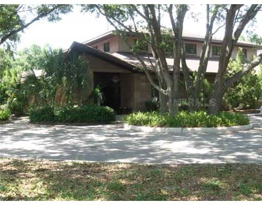
Property Record
347 Bolender Rd, Auburndale, FL 33823


NEARBY LISTINGS FOR SALE OR LEASE
Property Detail
347 Bolender Rd
Lakeland-Winter Haven, FL
Winona Park Realty And Fruit Co Subdivis
25-27-35-305000-000921
WINONA PARK REALTY & FRUIT CO SUB PB 1 PG 62 LOT 92 E 296.52 FT
Lightindustrial
Polk
X
Florida
12105C0335G
92
2024
4.23 AC
2025
Polk County
013001
Tampa/St Petersburg
11,789 SF
DEMOGRAPHICS near 347 Bolender Rd
1 Mile
3 Mile
5 Mile
2024 Total Population
6,277
34,021
79,420
2029 Population
7,686
41,274
96,416
Pop Growth 2024-2029
+ 22.45%
+ 21.32%
+ 21.40%
Average Age
38
41
41
2024 Total Households
2,151
12,808
30,691
HH Growth 2024-2029
+ 22.36%
+ 21.14%
+ 21.30%
Median Household Inc
$79,598
$62,032
$53,792
Avg Household Size
2.90
2.60
2.50
2024 Avg HH Vehicles
2.00
2.00
2.00
Median Home Value
$242,471
$221,173
$197,248
Median Year Built
1998
1988
1986
Nearby Places
Map Layers
Map Styles
 Street
 Aerial
- Restaurants
- Banks
- Shops
- Fitness
- Groceries
PUBLIC TRANSPORTATION
AIRPORT
Orlando International
DRIVE
WALK
Distance
Orlando International
50 min
45.7 mi
SALE & LEASE HISTORY
LISTING DATE
SALE/LEASE

Sep 25, 2016
For Lease
Nearby Properties
Address
Land Use
TOTAL SIZE
Lot Size
Zoning
Address
Land Use
TOTAL SIZE
Lot Size
Zoning
942,646 SF
91.30 AC
R3
Address
Land Use
TOTAL SIZE
Lot Size
Zoning
238,721 SF
11.66 AC
GI
Address
Land Use
TOTAL SIZE
Lot Size
Zoning
136,724 SF
4.62 AC
GI
Address
Land Use
TOTAL SIZE
Lot Size
Zoning
108,360 SF
4.23 AC
GI
Address
Land Use
TOTAL SIZE
Lot Size
Zoning
178,899 SF
10.09 AC
GI
Address
Land Use
TOTAL SIZE
Lot Size
Zoning
291,428 SF
59.34 AC
Address
Land Use
TOTAL SIZE
Lot Size
Zoning
129,567 SF
11.72 AC
C3
Address
Land Use
TOTAL SIZE
Lot Size
Zoning
277,729 SF
423.34 AC
Address
Land Use
TOTAL SIZE
Lot Size
Zoning
191,975 SF
14.28 AC
HI
Address
Land Use
TOTAL SIZE
Lot Size
Zoning
160,755 SF
9.94 AC
Address
Land Use
TOTAL SIZE
Lot Size
Zoning
320,765 SF
14.93 AC
GI
Address
Land Use
TOTAL SIZE
Lot Size
Zoning
42,400 SF
121.06 AC
RC
Address
Land Use
TOTAL SIZE
Lot Size
Zoning
106,376 SF
18.36 AC
Address
Land Use
TOTAL SIZE
Lot Size
Zoning
42,668 SF
9.44 AC
R2
Address
Land Use
TOTAL SIZE
Lot Size
Zoning
169,925 SF
11.88 AC
C3
Address
Land Use
TOTAL SIZE
Lot Size
Zoning
309,124 SF
31.33 AC
XX
Address
Land Use
TOTAL SIZE
Lot Size
Zoning
28,304 SF
10.28 AC
RE1
Address
Land Use
TOTAL SIZE
Lot Size
Zoning
122,260 SF
4.77 AC
Address
Land Use
TOTAL SIZE
Lot Size
Zoning
90,077 SF
12.41 AC
Address
Land Use
TOTAL SIZE
Lot Size
Zoning
69,835 SF
7.06 AC
CH
Address
Land Use
TOTAL SIZE
Lot Size
Zoning
84,312 SF
13.64 AC
Address
Land Use
TOTAL SIZE
Lot Size
Zoning
80,100 SF
4.68 AC
GI
Address
Land Use
TOTAL SIZE
Lot Size
Zoning
30,638 SF
4.22 AC
R3
Address
Land Use
TOTAL SIZE
Lot Size
Zoning
77,279 SF
12.12 AC
Address
Land Use
TOTAL SIZE
Lot Size
Zoning
58,918 SF
2.44 AC
LI
Address
Land Use
TOTAL SIZE
Lot Size
Zoning
55,836 SF
10.76 AC
R2
Address
Land Use
TOTAL SIZE
Lot Size
Zoning
192,825 SF
9.65 AC
LI
Address
Land Use
TOTAL SIZE
Lot Size
Zoning
151,567 SF
6.34 AC
GI
Address
Land Use
TOTAL SIZE
Lot Size
Zoning
23,800 SF
2.94 AC
Address
Land Use
TOTAL SIZE
Lot Size
Zoning
86,200 SF
15.50 AC
R3
The World's #1 Commercial Real Estate Marketplace
Connect with us
© 2025 CoStar Group
The information above has been obtained from sources believed reliable. While we do not doubt its accuracy we have not verified it and make no guarantee, warranty or representation about it. It is your responsibility to independently confirm its accuracy and completeness. Any projections, opinions, assumptions, or estimates used are for example only and do not represent the current or future performance of the property. The value of this transaction to you depends on tax and other factors which should be evaluated by your tax, financial, and legal advisors. You and your advisors should conduct a careful, independent investigation of the property to determine to your satisfaction the suitability of the property for your needs.