Property Record
347 E Flora St, Stockton, CA 95202


Property Detail
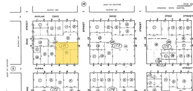
347 E Flora St
Stockton-Lodi, CA
20-NOW TAXABLE PER 2019-050265
139-171-16
San Joaquin
Apartment
California
O
1,3
2025
0.77 AC
2025
Downtown Stockton
000402
Stockton/Modesto
24,118 SF
NEARBY LISTINGS FOR SALE OR LEASE
DEMOGRAPHICS near 347 E Flora St
1 mile
3 mile
5 mile
2025 Total Population
23,488
165,079
313,396
2030 Population
24,598
172,027
325,902
Pop Growth 2025-2030
+ 4.73%
+ 4.21%
+ 3.99%
Average Age
38
36
37
2025 Total Households
8,930
51,330
96,620
HH Growth 2025-2030
+ 5.33%
+ 4.49%
+ 4.21%
Median Household Inc
$44,742
$62,953
$70,501
Avg Household Size
2.40
3.00
3.10
2025 Avg HH Vehicles
1.00
2.00
2.00
Median Home Value
$365,958
$361,853
$401,767
Median Year Built
1949
1964
1974
Nearby Places
Map Layers
Map Styles
 Street
 Aerial
Layers
 Traffic
 Biking
Places
Listings with unknown addresses are not visible on the map
- Restaurants
- Banks
- Shops
- Fitness
- Groceries
PUBLIC TRANSPORTATION
COMMUTER RAIL
Stockton- Robert J Cabral Station (ACE Train - Altamont Corridor Express)
Drive
Walk
Distance
Stockton- Robert J Cabral Station (ACE Train - Altamont Corridor Express)
2 min
15 min
0.8 mi
Stockton (San Joaquins - Amtrak)
Drive
Walk
Distance
Stockton (San Joaquins - Amtrak)
4 min
1.7 mi
AIRPORT
Stockton Metro
Drive
Walk
Distance
Stockton Metro
12 min
6.2 mi
Freight Ports
Port of Stockton
Drive
Walk
Distance
Port of Stockton
7 min
2.6 mi
SALE & LEASE HISTORY
LISTING DATE
SALE/LEASE

Sep 13, 2019
For Sale
Jul 23, 2021
For Sale
Nearby Properties
Address
Land Use
TOTAL SIZE
Lot Size
Zoning
Address
Land Use
TOTAL SIZE
Lot Size
Zoning
530,700 SF
8.35 AC
Address
Land Use
TOTAL SIZE
Lot Size
Zoning
30,080 SF
82.44 AC
Address
Land Use
TOTAL SIZE
Lot Size
Zoning
152,000 SF
1.31 AC
Address
Land Use
TOTAL SIZE
Lot Size
Zoning
4.78 AC
Address
Land Use
TOTAL SIZE
Lot Size
Zoning
656,200 SF
24.07 AC
IG
Address
Land Use
TOTAL SIZE
Lot Size
Zoning
10,208 SF
47.57 AC
Address
Land Use
TOTAL SIZE
Lot Size
Zoning
9,750 SF
136.94 AC
AU20
Address
Land Use
TOTAL SIZE
Lot Size
Zoning
502,000 SF
19.76 AC
Address
Land Use
TOTAL SIZE
Lot Size
Zoning
22.89 AC
Address
Land Use
TOTAL SIZE
Lot Size
Zoning
652,548 SF
35.24 AC
IL
Address
Land Use
TOTAL SIZE
Lot Size
Zoning
121,574 SF
5.49 AC
RHD
Address
Land Use
TOTAL SIZE
Lot Size
Zoning
328,500 SF
12.27 AC
Address
Land Use
TOTAL SIZE
Lot Size
Zoning
23,112 SF
9.20 AC
Address
Land Use
TOTAL SIZE
Lot Size
Zoning
277,300 SF
13.32 AC
Address
Land Use
TOTAL SIZE
Lot Size
Zoning
82,512 SF
4.14 AC
Address
Land Use
TOTAL SIZE
Lot Size
Zoning
219,572 SF
16.53 AC
IL
Address
Land Use
TOTAL SIZE
Lot Size
Zoning
247,850 SF
9.48 AC
Address
Land Use
TOTAL SIZE
Lot Size
Zoning
63,975 SF
6.60 AC
Address
Land Use
TOTAL SIZE
Lot Size
Zoning
23.30 AC
Address
Land Use
TOTAL SIZE
Lot Size
Zoning
15,203 SF
3.65 AC
Address
Land Use
TOTAL SIZE
Lot Size
Zoning
97,276 SF
5.46 AC
RHD
Address
Land Use
TOTAL SIZE
Lot Size
Zoning
8,000 SF
0.67 AC
Address
Land Use
TOTAL SIZE
Lot Size
Zoning
62,588 SF
43.56 AC
IW
Address
Land Use
TOTAL SIZE
Lot Size
Zoning
0.79 AC
Address
Land Use
TOTAL SIZE
Lot Size
Zoning
37,846 SF
2.94 AC
Address
Land Use
TOTAL SIZE
Lot Size
Zoning
17,573 SF
3.17 AC
Address
Land Use
TOTAL SIZE
Lot Size
Zoning
14,035 SF
10.02 AC
Address
Land Use
TOTAL SIZE
Lot Size
Zoning
2.42 AC
Address
Land Use
TOTAL SIZE
Lot Size
Zoning
2,876 SF
10.54 AC
The World's #1 Commercial Real Estate Marketplace
Connect with us
© 2026 CoStar Group
The information above has been obtained from sources believed reliable. While we do not doubt its accuracy we have not verified it and make no guarantee, warranty or representation about it. It is your responsibility to independently confirm its accuracy and completeness. Any projections, opinions, assumptions, or estimates used are for example only and do not represent the current or future performance of the property. The value of this transaction to you depends on tax and other factors which should be evaluated by your tax, financial, and legal advisors. You and your advisors should conduct a careful, independent investigation of the property to determine to your satisfaction the suitability of the property for your needs.