Property Record
347 Riverside Dr, North Grosvenordale, CT 06255
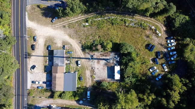
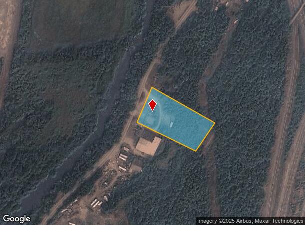
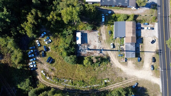
This Property Is For Sale
NEARBY LISTINGS FOR SALE OR LEASE
Property Detail
347 Riverside Dr
THOM-000085-000051-000004-A000000
Windham
Commercialbuilding
Connecticut
X
4-a
09015C0134F
2.05 AC
2024
Windham County
2025
Hartford
900200
Worcester, MA-CT
4,040 SF
DEMOGRAPHICS near 347 Riverside Dr
1 Mile
3 Mile
5 Mile
2024 Total Population
835
10,530
20,774
2029 Population
860
10,793
21,275
Pop Growth 2024-2029
+ 2.99%
+ 2.50%
+ 2.41%
Average Age
45
43
44
2024 Total Households
344
4,564
8,701
HH Growth 2024-2029
+ 3.20%
+ 2.61%
+ 2.52%
Median Household Inc
$84,635
$77,465
$86,792
Avg Household Size
2.30
2.30
2.30
2024 Avg HH Vehicles
2.00
2.00
2.00
Median Home Value
$280,262
$263,988
$293,540
Median Year Built
1972
1958
1965
Nearby Places
Map Layers
Map Styles
 Street
 Aerial
- Restaurants
- Banks
- Shops
- Fitness
- Groceries
PUBLIC TRANSPORTATION
AIRPORT
Worcester Regional
DRIVE
WALK
Distance
Worcester Regional
41 min
26.6 mi
Rhode Island Tf Green International
DRIVE
WALK
Distance
Rhode Island Tf Green International
57 min
43.5 mi
Freight Ports
Port of Davisville, RI
DRIVE
WALK
Distance
Port of Davisville, RI
68 min
52.7 mi
Nearby Properties
Address
Land Use
TOTAL SIZE
Lot Size
Zoning
Address
Land Use
TOTAL SIZE
Lot Size
Zoning
199,059 SF
31.65 AC
R-10
Address
Land Use
TOTAL SIZE
Lot Size
Zoning
35.85 AC
DMRD
Address
Land Use
TOTAL SIZE
Lot Size
Zoning
104,330 SF
15 AC
R-10
Address
Land Use
TOTAL SIZE
Lot Size
Zoning
37,203 SF
7.21 AC
P
Address
Land Use
TOTAL SIZE
Lot Size
Zoning
17.41 AC
GC
Address
Land Use
TOTAL SIZE
Lot Size
Zoning
142,599 SF
17.59 AC
HC
Address
Land Use
TOTAL SIZE
Lot Size
Zoning
68,227 SF
55 AC
AG-2
Address
Land Use
TOTAL SIZE
Lot Size
Zoning
4,212 SF
8.25 AC
R-10
Address
Land Use
TOTAL SIZE
Lot Size
Zoning
7,009 SF
15.70 AC
TCDD
Address
Land Use
TOTAL SIZE
Lot Size
Zoning
70,608 SF
5.70 AC
HC
Address
Land Use
TOTAL SIZE
Lot Size
Zoning
101,136 SF
15.07 AC
HC
Address
Land Use
TOTAL SIZE
Lot Size
Zoning
38.20 AC
RRAD
Address
Land Use
TOTAL SIZE
Lot Size
Zoning
31,860 SF
7.69 AC
HC
Address
Land Use
TOTAL SIZE
Lot Size
Zoning
28,990 SF
17 AC
R-40
Address
Land Use
TOTAL SIZE
Lot Size
Zoning
61,373 SF
121.12 AC
TCVD
Address
Land Use
TOTAL SIZE
Lot Size
Zoning
64,209 SF
4.91 AC
R-7
Address
Land Use
TOTAL SIZE
Lot Size
Zoning
52,724 SF
6.46 AC
SZD
Address
Land Use
TOTAL SIZE
Lot Size
Zoning
30,082 SF
12 AC
HC
Address
Land Use
TOTAL SIZE
Lot Size
Zoning
31,000 SF
Address
Land Use
TOTAL SIZE
Lot Size
Zoning
31,000 SF
Address
Land Use
TOTAL SIZE
Lot Size
Zoning
15,859 SF
0.65 AC
GC
Address
Land Use
TOTAL SIZE
Lot Size
Zoning
35,170 SF
1.23 AC
GC
Address
Land Use
TOTAL SIZE
Lot Size
Zoning
123,434 SF
49.50 AC
BDD
Address
Land Use
TOTAL SIZE
Lot Size
Zoning
18,268 SF
3 AC
M/OD
Address
Land Use
TOTAL SIZE
Lot Size
Zoning
102 AC
RRAD
Address
Land Use
TOTAL SIZE
Lot Size
Zoning
3.87 AC
R-7
Address
Land Use
TOTAL SIZE
Lot Size
Zoning
5 AC
TCVD
Address
Land Use
TOTAL SIZE
Lot Size
Zoning
2.26 AC
R-7
Address
Land Use
TOTAL SIZE
Lot Size
Zoning
4.37 AC
HC
Address
Land Use
TOTAL SIZE
Lot Size
Zoning
98.97 AC
TCVD
The World's #1 Commercial Real Estate Marketplace
Connect with us
© 2025 CoStar Group
The information above has been obtained from sources believed reliable. While we do not doubt its accuracy we have not verified it and make no guarantee, warranty or representation about it. It is your responsibility to independently confirm its accuracy and completeness. Any projections, opinions, assumptions, or estimates used are for example only and do not represent the current or future performance of the property. The value of this transaction to you depends on tax and other factors which should be evaluated by your tax, financial, and legal advisors. You and your advisors should conduct a careful, independent investigation of the property to determine to your satisfaction the suitability of the property for your needs.