Property Record
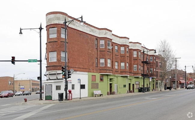
3473 S Archer Ave, Chicago, IL 60608


Current Lease Availabilities
NEARBY LISTINGS FOR SALE OR LEASE
Property Detail
3473 S Archer Ave
Chicago-Naperville-Elgin, IL-IN-WI
Dohertys Sub
17-31-124-001-0000
DANIEL E (DOHERTYS) SUB OF BLK10 IN S J WALKERS SUB O F OF PTS LYG SOUTH OF CANAL IN THE EH NE SEC 36-39-13 & NW SEC 31-39-14
Commercialnec
Cook
X
Illinois
17031C0508J
20,21
2023
0.11 AC
2025
McKinley Park
840300
Chicago
13,620 SF
DEMOGRAPHICS near 3473 S Archer Ave
1 Mile
3 Mile
5 Mile
2024 Total Population
18,843
279,531
846,041
2029 Population
17,310
257,696
803,435
Pop Growth 2024-2029
(8.14%)
(7.81%)
(5.04%)
Average Age
38
36
36
2024 Total Households
6,260
93,756
333,892
HH Growth 2024-2029
(8.58%)
(8.06%)
(4.65%)
Median Household Inc
$58,359
$46,220
$61,086
Avg Household Size
2.90
2.80
2.40
2024 Avg HH Vehicles
1.00
1.00
1.00
Median Home Value
$272,410
$255,641
$286,007
Median Year Built
1947
1948
1957
Nearby Places
Map Layers
Map Styles
 Street
 Aerial
- Restaurants
- Banks
- Shops
- Fitness
- Groceries
PUBLIC TRANSPORTATION
TRANSIT/SUBWAY
35th/Archer Station (Orange Line - Chicago Transit Authority "L" Trains (The "L"))
DRIVE
WALK
Distance
35th/Archer Station (Orange Line - Chicago Transit Authority "L" Trains (The "L"))
1 min
5 min
0.2 mi
Ashland Station (Orange Line) (Orange Line - Chicago Transit Authority "L" Trains (The "L"))
DRIVE
WALK
Distance
Ashland Station (Orange Line) (Orange Line - Chicago Transit Authority "L" Trains (The "L"))
2 min
18 min
0.9 mi
COMMUTER RAIL
Western Avenue Station (BNSF) (Burlington Northern-Santa Fe Railway Line - Northeast Illinois Regional Commuter Railroad (Metra))
DRIVE
WALK
Distance
Western Avenue Station (BNSF) (Burlington Northern-Santa Fe Railway Line - Northeast Illinois Regional Commuter Railroad (Metra))
5 min
2.3 mi
DRIVE
WALK
Distance
5 min
2.5 mi
AIRPORT
Chicago Midway International
DRIVE
WALK
Distance
Chicago Midway International
12 min
6.3 mi
Chicago O'Hare International
DRIVE
WALK
Distance
Chicago O'Hare International
57 min
22.2 mi
Nearby Properties
Address
Land Use
TOTAL SIZE
Lot Size
Zoning
Address
Land Use
TOTAL SIZE
Lot Size
Zoning
474,979 SF
29.67 AC
PD 553
Address
Land Use
TOTAL SIZE
Lot Size
Zoning
0.85 AC
DS-3
Address
Land Use
TOTAL SIZE
Lot Size
Zoning
3.17 AC
PD 96
Address
Land Use
TOTAL SIZE
Lot Size
Zoning
4.71 AC
PD 1196
Address
Land Use
TOTAL SIZE
Lot Size
Zoning
4.11 AC
M2-3
Address
Land Use
TOTAL SIZE
Lot Size
Zoning
2.98 AC
PD 1196
Address
Land Use
TOTAL SIZE
Lot Size
Zoning
460,333 SF
2.62 AC
C2-3
Address
Land Use
TOTAL SIZE
Lot Size
Zoning
136,720 SF
0.54 AC
PD 1
Address
Land Use
TOTAL SIZE
Lot Size
Zoning
134,800 SF
2.53 AC
PD 1273
Address
Land Use
TOTAL SIZE
Lot Size
Zoning
552,300 SF
0.69 AC
PMD 11
Address
Land Use
TOTAL SIZE
Lot Size
Zoning
Address
Land Use
TOTAL SIZE
Lot Size
Zoning
27.31 AC
PD 1424
Address
Land Use
TOTAL SIZE
Lot Size
Zoning
133,354 SF
PD 1198
Address
Land Use
TOTAL SIZE
Lot Size
Zoning
225,784 SF
0.69 AC
DS-3
Address
Land Use
TOTAL SIZE
Lot Size
Zoning
169,435 SF
11.35 AC
PD 307
Address
Land Use
TOTAL SIZE
Lot Size
Zoning
433,317 SF
0.52 AC
PMD 11
Address
Land Use
TOTAL SIZE
Lot Size
Zoning
307,277 SF
9.90 AC
PMD 11
Address
Land Use
TOTAL SIZE
Lot Size
Zoning
72,893 SF
4.43 AC
PD 90
Address
Land Use
TOTAL SIZE
Lot Size
Zoning
475,000 SF
14.01 AC
PMD 8
Address
Land Use
TOTAL SIZE
Lot Size
Zoning
1.97 AC
PD 30
Address
Land Use
TOTAL SIZE
Lot Size
Zoning
3.66 AC
M2-3
Address
Land Use
TOTAL SIZE
Lot Size
Zoning
363,780 SF
1.77 AC
PD 66
Address
Land Use
TOTAL SIZE
Lot Size
Zoning
0.84 AC
B1-3
Address
Land Use
TOTAL SIZE
Lot Size
Zoning
633,057 SF
34.96 AC
PMD 8
Address
Land Use
TOTAL SIZE
Lot Size
Zoning
0.27 AC
PD 1
Address
Land Use
TOTAL SIZE
Lot Size
Zoning
43,896 SF
5.18 AC
M2-1
Address
Land Use
TOTAL SIZE
Lot Size
Zoning
240,400 SF
1.34 AC
PMD 11
Address
Land Use
TOTAL SIZE
Lot Size
Zoning
201,750 SF
0.66 AC
PD 96
Address
Land Use
TOTAL SIZE
Lot Size
Zoning
260,481 SF
12.93 AC
PD 463
Address
Land Use
TOTAL SIZE
Lot Size
Zoning
The World's #1 Commercial Real Estate Marketplace
Connect with us
© 2026 CoStar Group
The information above has been obtained from sources believed reliable. While we do not doubt its accuracy we have not verified it and make no guarantee, warranty or representation about it. It is your responsibility to independently confirm its accuracy and completeness. Any projections, opinions, assumptions, or estimates used are for example only and do not represent the current or future performance of the property. The value of this transaction to you depends on tax and other factors which should be evaluated by your tax, financial, and legal advisors. You and your advisors should conduct a careful, independent investigation of the property to determine to your satisfaction the suitability of the property for your needs.