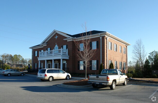
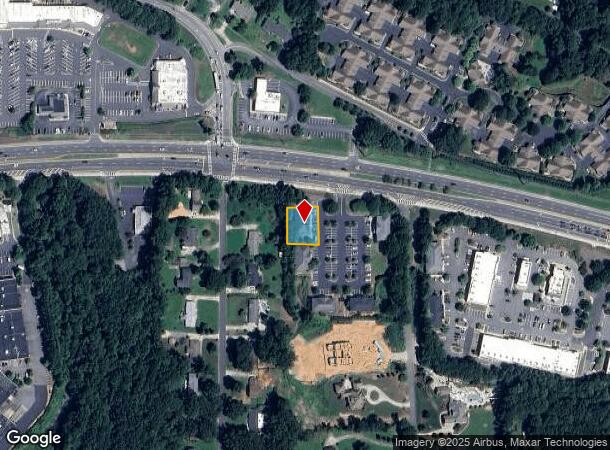
Property Record
3475 Dallas Hwy Sw, Marietta, GA 30064

Current Lease Availabilities
NEARBY LISTINGS FOR SALE OR LEASE
Property Detail
3475 Dallas Hwy Sw
20-0332-0-149-0
Village/West Cobb
Officebuilding
Cobb
X
Georgia
13067C0084G
6
2025
0.26 AC
2025
Kennesaw/Town Center
030263
Atlanta
6,328 SF
Atlanta-Sandy Springs-Roswell, GA
DEMOGRAPHICS near 3475 Dallas Hwy Sw
1 Mile
3 Mile
5 Mile
2024 Total Population
4,871
40,399
133,040
2029 Population
4,996
41,088
135,344
Pop Growth 2024-2029
+ 2.57%
+ 1.71%
+ 1.73%
Average Age
44
42
41
2024 Total Households
1,769
13,706
46,409
HH Growth 2024-2029
+ 2.66%
+ 1.72%
+ 1.78%
Median Household Inc
$101,608
$125,663
$113,444
Avg Household Size
2.70
2.90
2.80
2024 Avg HH Vehicles
2.00
2.00
2.00
Median Home Value
$361,052
$418,367
$375,296
Median Year Built
1991
1995
1994
Nearby Places
Map Layers
Map Styles
 Street
 Aerial
- Restaurants
- Banks
- Shops
- Fitness
- Groceries
PUBLIC TRANSPORTATION
AIRPORT
Hartsfield - Jackson Atlanta International
DRIVE
WALK
Distance
Hartsfield - Jackson Atlanta International
53 min
35.1 mi
Nearby Properties
Address
Land Use
TOTAL SIZE
Lot Size
Zoning
Address
Land Use
TOTAL SIZE
Lot Size
Zoning
264,394 SF
27.59 AC
NRC
Address
Land Use
TOTAL SIZE
Lot Size
Zoning
3,240 SF
24.28 AC
RSL
Address
Land Use
TOTAL SIZE
Lot Size
Zoning
83.83 AC
R30
Address
Land Use
TOTAL SIZE
Lot Size
Zoning
81,639 SF
15.82 AC
NRC
Address
Land Use
TOTAL SIZE
Lot Size
Zoning
97,836 SF
8.88 AC
NRC/CRC
Address
Land Use
TOTAL SIZE
Lot Size
Zoning
108,435 SF
13.69 AC
NRC
Address
Land Use
TOTAL SIZE
Lot Size
Zoning
9.86 AC
RSL
Address
Land Use
TOTAL SIZE
Lot Size
Zoning
2,430 SF
9.17 AC
RSL
Address
Land Use
TOTAL SIZE
Lot Size
Zoning
99,972 SF
3.18 AC
NRC/O&I
Address
Land Use
TOTAL SIZE
Lot Size
Zoning
134,362 SF
23.12 AC
CRC/WS
Address
Land Use
TOTAL SIZE
Lot Size
Zoning
7,095 SF
7.93 AC
OI
Address
Land Use
TOTAL SIZE
Lot Size
Zoning
63,696 SF
159.75 AC
R-20
Address
Land Use
TOTAL SIZE
Lot Size
Zoning
1,524 SF
51.95 AC
R30
Address
Land Use
TOTAL SIZE
Lot Size
Zoning
124,231 SF
10.25 AC
CRC
Address
Land Use
TOTAL SIZE
Lot Size
Zoning
116,500 SF
23.77 AC
CRC/LRO
Address
Land Use
TOTAL SIZE
Lot Size
Zoning
41,412 SF
7.35 AC
NRC
Address
Land Use
TOTAL SIZE
Lot Size
Zoning
19,059 SF
42.74 AC
R80
Address
Land Use
TOTAL SIZE
Lot Size
Zoning
99,900 SF
2.69 AC
GC
Address
Land Use
TOTAL SIZE
Lot Size
Zoning
78,312 SF
6.37 AC
NRC
Address
Land Use
TOTAL SIZE
Lot Size
Zoning
67,794 SF
4.85 AC
NRC
Address
Land Use
TOTAL SIZE
Lot Size
Zoning
3,602 SF
2.57 AC
RSL
Address
Land Use
TOTAL SIZE
Lot Size
Zoning
24,384 SF
2.47 AC
CRC
Address
Land Use
TOTAL SIZE
Lot Size
Zoning
38,674 SF
3.08 AC
NRC
Address
Land Use
TOTAL SIZE
Lot Size
Zoning
18,577 SF
1.95 AC
NRC
Address
Land Use
TOTAL SIZE
Lot Size
Zoning
14,594 SF
4.73 AC
CRC/WS
Address
Land Use
TOTAL SIZE
Lot Size
Zoning
18,703 SF
2.61 AC
CRC
Address
Land Use
TOTAL SIZE
Lot Size
Zoning
19,394 SF
1.84 AC
CRC/WS
Address
Land Use
TOTAL SIZE
Lot Size
Zoning
14,314 SF
2.73 AC
Address
Land Use
TOTAL SIZE
Lot Size
Zoning
16,776 SF
2.65 AC
GC
Address
Land Use
TOTAL SIZE
Lot Size
Zoning
16,240 SF
1.73 AC
NRC
The World's #1 Commercial Real Estate Marketplace
Connect with us
© 2025 CoStar Group
The information above has been obtained from sources believed reliable. While we do not doubt its accuracy we have not verified it and make no guarantee, warranty or representation about it. It is your responsibility to independently confirm its accuracy and completeness. Any projections, opinions, assumptions, or estimates used are for example only and do not represent the current or future performance of the property. The value of this transaction to you depends on tax and other factors which should be evaluated by your tax, financial, and legal advisors. You and your advisors should conduct a careful, independent investigation of the property to determine to your satisfaction the suitability of the property for your needs.