Property Record
3475 Omro Rd, Oshkosh, WI 54904


Save to a Folder
{{folder.Name}}
{{folder.ListingIds.length}} Properties
{{folder.ListingIds.length}} Property
Create a New Folder
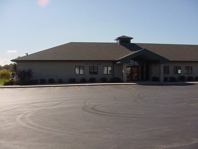
Property Detail
3475 Omro Rd
Oshkosh-Neenah, WI
PT NW SW DESC AS LOT 1 OF CSM-2430 2.00 A.
002-01450201
WINNEBAGO
Commercialnec
Wisconsin
B2
1
B and X Area of moderate flood hazard, usually the area between the limits of the 100-year and 500-year floods.
2 AC
2024
Appleton/Oshkosh
2025
Other Market Areas
001804
NEARBY LISTINGS FOR SALE OR LEASE
-
-
View all Oshkosh listings for lease on LoopNet.com
DEMOGRAPHICS near 3475 Omro Rd
1 mile
3 mile
5 mile
2025 Total Population
3,749
25,751
72,047
2030 Population
3,802
26,278
72,998
Pop Growth 2025-2030
+ 1.41%
+ 2.05%
+ 1.32%
Average Age
42
42
40
2025 Total Households
1,329
11,271
29,793
HH Growth 2025-2030
+ 1.35%
+ 2.17%
+ 1.49%
Median Household Inc
$111,202
$70,118
$65,030
Avg Household Size
2.70
2.20
2.20
2025 Avg HH Vehicles
2.00
2.00
2.00
Median Home Value
$321,272
$250,873
$198,675
Median Year Built
1992
1990
1973
Nearby Places
Map Layers
Map Styles
 Street
 Aerial
Layers
 Traffic
 Biking
Places
Listings with unknown addresses are not visible on the map
- Restaurants
- Banks
- Shops
- Fitness
- Groceries
PUBLIC TRANSPORTATION
AIRPORT
Appleton International
Drive
Walk
Distance
Appleton International
31 min
22.6 mi
Freight Ports
Port Milwaukee
Drive
Walk
Distance
Port Milwaukee
108 min
90.9 mi
SALE & LEASE HISTORY
LISTING DATE
SALE/LEASE

Sep 28, 2016
For Lease
Sep 25, 2016
For Lease
Sep 14, 2024
For Lease
May 16, 2017
For Lease
Nearby Properties
Address
Land Use
TOTAL SIZE
Lot Size
Zoning
Address
Land Use
TOTAL SIZE
Lot Size
Zoning
32.81 AC
CBPPD
Address
Land Use
TOTAL SIZE
Lot Size
Zoning
195,810 SF
31.08 AC
MR-20
Address
Land Use
TOTAL SIZE
Lot Size
Zoning
208,278 SF
22.77 AC
C2
Address
Land Use
TOTAL SIZE
Lot Size
Zoning
255,080 SF
21.29 AC
MR-12
Address
Land Use
TOTAL SIZE
Lot Size
Zoning
14.77 AC
SMU-PD
Address
Land Use
TOTAL SIZE
Lot Size
Zoning
161,640 SF
18.54 AC
C-2PD
Address
Land Use
TOTAL SIZE
Lot Size
Zoning
2.40 AC
CBP-PD
Address
Land Use
TOTAL SIZE
Lot Size
Zoning
152,505 SF
6.54 AC
MR-20-RFO
Address
Land Use
TOTAL SIZE
Lot Size
Zoning
136,368 SF
10.24 AC
C-2PD
Address
Land Use
TOTAL SIZE
Lot Size
Zoning
53,998 SF
3.63 AC
C2
Address
Land Use
TOTAL SIZE
Lot Size
Zoning
175,906 SF
11.60 AC
MR-20
Address
Land Use
TOTAL SIZE
Lot Size
Zoning
341,904 SF
40.71 AC
HI
Address
Land Use
TOTAL SIZE
Lot Size
Zoning
25,456 SF
1.74 AC
R1;SINGLE
Address
Land Use
TOTAL SIZE
Lot Size
Zoning
80,118 SF
7.88 AC
C2
Address
Land Use
TOTAL SIZE
Lot Size
Zoning
34,340 SF
8.56 AC
C2
Address
Land Use
TOTAL SIZE
Lot Size
Zoning
140,296 SF
13.58 AC
C-2
Address
Land Use
TOTAL SIZE
Lot Size
Zoning
4.76 AC
C2
Address
Land Use
TOTAL SIZE
Lot Size
Zoning
106,340 SF
5.37 AC
MR-20
Address
Land Use
TOTAL SIZE
Lot Size
Zoning
1.81 AC
SMU
Address
Land Use
TOTAL SIZE
Lot Size
Zoning
14,796 SF
18.51 AC
MR-12
Address
Land Use
TOTAL SIZE
Lot Size
Zoning
100,361 SF
14.25 AC
SMU-PD
Address
Land Use
TOTAL SIZE
Lot Size
Zoning
100,912 SF
5.50 AC
MR-20
Address
Land Use
TOTAL SIZE
Lot Size
Zoning
96,516 SF
2.62 AC
R5
Address
Land Use
TOTAL SIZE
Lot Size
Zoning
88,128 SF
6.33 AC
MR-12
Address
Land Use
TOTAL SIZE
Lot Size
Zoning
83,538 SF
9.72 AC
M1
Address
Land Use
TOTAL SIZE
Lot Size
Zoning
129,759 SF
8.52 AC
SMU
Address
Land Use
TOTAL SIZE
Lot Size
Zoning
26,375 SF
33.11 AC
C2
Address
Land Use
TOTAL SIZE
Lot Size
Zoning
71,538 SF
7.89 AC
I-PD
Address
Land Use
TOTAL SIZE
Lot Size
Zoning
137,188 SF
12.65 AC
SMU
Address
Land Use
TOTAL SIZE
Lot Size
Zoning
22,882 SF
33.11 AC
C2
The World's #1 Commercial Real Estate Marketplace
Connect with us
© 2026 CoStar Group
The information above has been obtained from sources believed reliable. While we do not doubt its accuracy we have not verified it and make no guarantee, warranty or representation about it. It is your responsibility to independently confirm its accuracy and completeness. Any projections, opinions, assumptions, or estimates used are for example only and do not represent the current or future performance of the property. The value of this transaction to you depends on tax and other factors which should be evaluated by your tax, financial, and legal advisors. You and your advisors should conduct a careful, independent investigation of the property to determine to your satisfaction the suitability of the property for your needs.