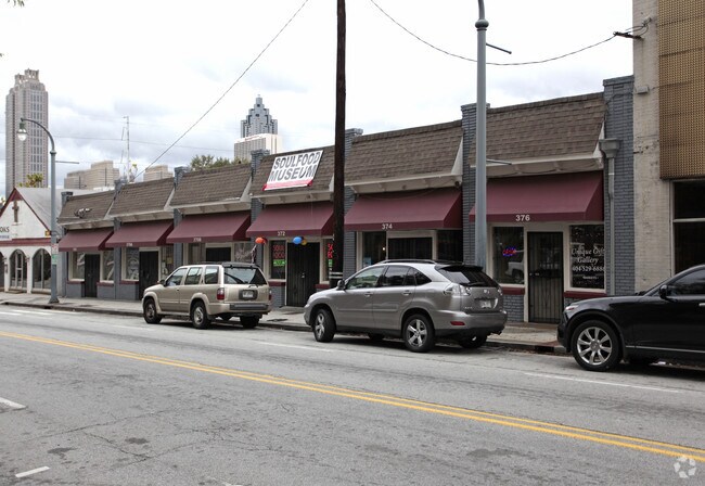
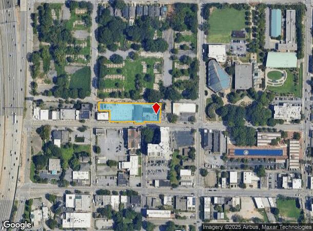
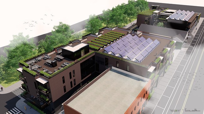
Property Record
348 Auburn Ave Ne, Atlanta, GA 30312
NEARBY LISTINGS FOR SALE OR LEASE
Property Detail
348 Auburn Ave Ne
Atlanta-Sandy Springs-Roswell, GA
KA: THE PORCH AT AUBURN APARTMENTS AN:OLD FUNERAL HOME STILL STANDING 5/25 26CB: CHK FOR RENO/DEMO OF OLD BLDGS
14-0046-0010-258-9
Fulton
Apartment
Georgia
2023
0.95 AC
2025
CBD
002802
Atlanta
77,600 SF
DEMOGRAPHICS near 348 Auburn Ave Ne
1 Mile
3 Mile
5 Mile
2024 Total Population
34,384
203,251
397,402
2029 Population
35,565
210,759
410,240
Pop Growth 2024-2029
+ 3.43%
+ 3.69%
+ 3.23%
Average Age
34
35
36
2024 Total Households
17,720
97,669
181,962
HH Growth 2024-2029
+ 3.85%
+ 3.98%
+ 3.49%
Median Household Inc
$81,484
$84,039
$80,270
Avg Household Size
1.60
1.80
2.00
2024 Avg HH Vehicles
1.00
1.00
1.00
Median Home Value
$452,809
$474,843
$455,686
Median Year Built
1999
1997
1988
Nearby Places
- Restaurants
- Banks
- Shops
- Fitness
- Groceries
PUBLIC TRANSPORTATION
TRANSIT/SUBWAY
King Historic District (Atlanta Streetcar - Metropolitan Atlanta Rapid Transit Authority (MARTA))
DRIVE
WALK
Distance
King Historic District (Atlanta Streetcar - Metropolitan Atlanta Rapid Transit Authority (MARTA))
0 min
1 min
0.0 mi
Edgewood Ave (Atlanta Streetcar - Metropolitan Atlanta Rapid Transit Authority (MARTA))
DRIVE
WALK
Distance
Edgewood Ave (Atlanta Streetcar - Metropolitan Atlanta Rapid Transit Authority (MARTA))
0 min
3 min
0.1 mi
Dobbs Plaza (Atlanta Streetcar - Metropolitan Atlanta Rapid Transit Authority (MARTA))
DRIVE
WALK
Distance
Dobbs Plaza (Atlanta Streetcar - Metropolitan Atlanta Rapid Transit Authority (MARTA))
2 min
3 min
0.2 mi
Sweet Auburn Market (Atlanta Streetcar - Metropolitan Atlanta Rapid Transit Authority (MARTA))
DRIVE
WALK
Distance
Sweet Auburn Market (Atlanta Streetcar - Metropolitan Atlanta Rapid Transit Authority (MARTA))
1 min
6 min
0.3 mi
Auburn Ave (Atlanta Streetcar - Metropolitan Atlanta Rapid Transit Authority (MARTA))
DRIVE
WALK
Distance
Auburn Ave (Atlanta Streetcar - Metropolitan Atlanta Rapid Transit Authority (MARTA))
0 min
7 min
0.4 mi
COMMUTER RAIL
Atlanta (Crescent - Amtrak)
DRIVE
WALK
Distance
Atlanta (Crescent - Amtrak)
7 min
3.9 mi
AIRPORT
Hartsfield - Jackson Atlanta International
DRIVE
WALK
Distance
Hartsfield - Jackson Atlanta International
16 min
9.9 mi
Freight Ports
Georgia Ports - Savannah
DRIVE
WALK
Distance
Georgia Ports - Savannah
279 min
249.2 mi
Nearby Properties
Address
Land Use
TOTAL SIZE
Lot Size
Zoning
Address
Land Use
TOTAL SIZE
Lot Size
Zoning
19.94 AC
SPI1
Address
Land Use
TOTAL SIZE
Lot Size
Zoning
1,585,451 SF
1.97 AC
SPI2
Address
Land Use
TOTAL SIZE
Lot Size
Zoning
2,283,599 SF
12.93 AC
I1
Address
Land Use
TOTAL SIZE
Lot Size
Zoning
9.80 AC
C5
Address
Land Use
TOTAL SIZE
Lot Size
Zoning
179.40 AC
R4
Address
Land Use
TOTAL SIZE
Lot Size
Zoning
3.16 AC
SPI1
Address
Land Use
TOTAL SIZE
Lot Size
Zoning
9 AC
C5
Address
Land Use
TOTAL SIZE
Lot Size
Zoning
10.27 AC
C5
Address
Land Use
TOTAL SIZE
Lot Size
Zoning
1,039,831 SF
0.31 AC
C4
Address
Land Use
TOTAL SIZE
Lot Size
Zoning
1,227,912 SF
2.15 AC
SPI4
Address
Land Use
TOTAL SIZE
Lot Size
Zoning
1,736,017 SF
3.63 AC
SPI2
Address
Land Use
TOTAL SIZE
Lot Size
Zoning
1,300,309 SF
4.81 AC
SPI1
Address
Land Use
TOTAL SIZE
Lot Size
Zoning
1,434,872 SF
1.89 AC
SPI1
Address
Land Use
TOTAL SIZE
Lot Size
Zoning
61.57 AC
C5
Address
Land Use
TOTAL SIZE
Lot Size
Zoning
1,116,157 SF
1.48 AC
SPI3
Address
Land Use
TOTAL SIZE
Lot Size
Zoning
1,467,469 SF
0.07 AC
C4
Address
Land Use
TOTAL SIZE
Lot Size
Zoning
10,954,869 SF
28.88 AC
C3
Address
Land Use
TOTAL SIZE
Lot Size
Zoning
1.55 AC
SPI1
Address
Land Use
TOTAL SIZE
Lot Size
Zoning
1,646,011 SF
3.74 AC
SPI4
Address
Land Use
TOTAL SIZE
Lot Size
Zoning
7 AC
C3
Address
Land Use
TOTAL SIZE
Lot Size
Zoning
342,275 SF
0.70 AC
SPI3
Address
Land Use
TOTAL SIZE
Lot Size
Zoning
903,732 SF
0.34 AC
SPI1
Address
Land Use
TOTAL SIZE
Lot Size
Zoning
467,847 SF
1.62 AC
I2
Address
Land Use
TOTAL SIZE
Lot Size
Zoning
1,314,183 SF
2.61 AC
SPI1
Address
Land Use
TOTAL SIZE
Lot Size
Zoning
2,577,342 SF
2.04 AC
SPI1
Address
Land Use
TOTAL SIZE
Lot Size
Zoning
1,356,182 SF
2.52 AC
SPI4
Address
Land Use
TOTAL SIZE
Lot Size
Zoning
1,121,700 SF
2.21 AC
I2
Address
Land Use
TOTAL SIZE
Lot Size
Zoning
13,340,229 SF
3.68 AC
SPI1
Address
Land Use
TOTAL SIZE
Lot Size
Zoning
415,551 SF
1.13 AC
C4
Address
Land Use
TOTAL SIZE
Lot Size
Zoning
628,608 SF
0.39 AC
SPI4
The World's #1 Commercial Real Estate Marketplace
Connect with us
© 2025 CoStar Group
The information above has been obtained from sources believed reliable. While we do not doubt its accuracy we have not verified it and make no guarantee, warranty or representation about it. It is your responsibility to independently confirm its accuracy and completeness. Any projections, opinions, assumptions, or estimates used are for example only and do not represent the current or future performance of the property. The value of this transaction to you depends on tax and other factors which should be evaluated by your tax, financial, and legal advisors. You and your advisors should conduct a careful, independent investigation of the property to determine to your satisfaction the suitability of the property for your needs.