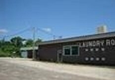
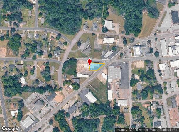
Property Record
348 Andrews Ave, Ozark, AL 36360

NEARBY LISTINGS FOR SALE OR LEASE
Property Detail
348 Andrews Ave
06-08-33-1-009-001.0000
143.84' X 188.71' IRR LOT IN PT NW4-NE4 BEG SW INT OF REYNOLDS ST & E ANDREWS AVE; SLY 143.84'; W 87.70'; N 96.66';E 188.71'
Conveniencestore
Dale
X
Alabama
01045C0135D
0.62 AC
2024
Dothan/Enterprise
2024
Other Market Areas
020700
Ozark, AL
DEMOGRAPHICS near 348 Andrews Ave
1 Mile
3 Mile
5 Mile
2024 Total Population
3,607
9,984
14,832
2029 Population
3,648
9,988
14,797
Pop Growth 2024-2029
+ 1.14%
+ 0.04%
(0.24%)
Average Age
39
42
43
2024 Total Households
1,630
4,347
6,352
HH Growth 2024-2029
+ 1.23%
+ 0.18%
(0.11%)
Median Household Inc
$23,550
$39,933
$43,015
Avg Household Size
2.20
2.20
2.30
2024 Avg HH Vehicles
1.00
2.00
2.00
Median Home Value
$93,731
$140,618
$139,937
Median Year Built
1965
1970
1975
Nearby Places
Map Layers
Map Styles
 Street
 Aerial
- Restaurants
- Banks
- Shops
- Fitness
- Groceries
PUBLIC TRANSPORTATION
AIRPORT
Dothan Regional
DRIVE
WALK
Distance
Dothan Regional
29 min
17.8 mi
Freight Ports
Port of Panama City
DRIVE
WALK
Distance
Port of Panama City
143 min
107.6 mi
SALE & LEASE HISTORY
LISTING DATE
SALE/LEASE

Sep 24, 2016
For Sale
Nearby Properties
Address
Land Use
TOTAL SIZE
Lot Size
Zoning
Address
Land Use
TOTAL SIZE
Lot Size
Zoning
7.90 AC
Address
Land Use
TOTAL SIZE
Lot Size
Zoning
160,913 SF
24.70 AC
Address
Land Use
TOTAL SIZE
Lot Size
Zoning
220,000 SF
42.61 AC
Address
Land Use
TOTAL SIZE
Lot Size
Zoning
17,220 SF
0.50 AC
Address
Land Use
TOTAL SIZE
Lot Size
Zoning
10,552 SF
9.30 AC
Address
Land Use
TOTAL SIZE
Lot Size
Zoning
1,902 SF
10 AC
Address
Land Use
TOTAL SIZE
Lot Size
Zoning
12,464 SF
3 AC
O
Address
Land Use
TOTAL SIZE
Lot Size
Zoning
30 AC
Address
Land Use
TOTAL SIZE
Lot Size
Zoning
4.04 AC
Address
Land Use
TOTAL SIZE
Lot Size
Zoning
8,490 SF
1.96 AC
Address
Land Use
TOTAL SIZE
Lot Size
Zoning
1.80 AC
Address
Land Use
TOTAL SIZE
Lot Size
Zoning
0.96 AC
Address
Land Use
TOTAL SIZE
Lot Size
Zoning
12,800 SF
6.50 AC
Address
Land Use
TOTAL SIZE
Lot Size
Zoning
1,680 SF
2.65 AC
Address
Land Use
TOTAL SIZE
Lot Size
Zoning
16,224 SF
1.70 AC
Address
Land Use
TOTAL SIZE
Lot Size
Zoning
3,780 SF
2.50 AC
Address
Land Use
TOTAL SIZE
Lot Size
Zoning
25,828 SF
7.20 AC
Address
Land Use
TOTAL SIZE
Lot Size
Zoning
29,600 SF
8.20 AC
Address
Land Use
TOTAL SIZE
Lot Size
Zoning
5,810 SF
9.50 AC
Address
Land Use
TOTAL SIZE
Lot Size
Zoning
14 AC
Address
Land Use
TOTAL SIZE
Lot Size
Zoning
860 SF
2.90 AC
Address
Land Use
TOTAL SIZE
Lot Size
Zoning
16 AC
Address
Land Use
TOTAL SIZE
Lot Size
Zoning
Address
Land Use
TOTAL SIZE
Lot Size
Zoning
7.50 AC
Address
Land Use
TOTAL SIZE
Lot Size
Zoning
5.89 AC
Address
Land Use
TOTAL SIZE
Lot Size
Zoning
12,000 SF
1.70 AC
Address
Land Use
TOTAL SIZE
Lot Size
Zoning
8,064 SF
11.70 AC
Address
Land Use
TOTAL SIZE
Lot Size
Zoning
Address
Land Use
TOTAL SIZE
Lot Size
Zoning
7.76 AC
The World's #1 Commercial Real Estate Marketplace
Connect with us
© 2025 CoStar Group
The information above has been obtained from sources believed reliable. While we do not doubt its accuracy we have not verified it and make no guarantee, warranty or representation about it. It is your responsibility to independently confirm its accuracy and completeness. Any projections, opinions, assumptions, or estimates used are for example only and do not represent the current or future performance of the property. The value of this transaction to you depends on tax and other factors which should be evaluated by your tax, financial, and legal advisors. You and your advisors should conduct a careful, independent investigation of the property to determine to your satisfaction the suitability of the property for your needs.