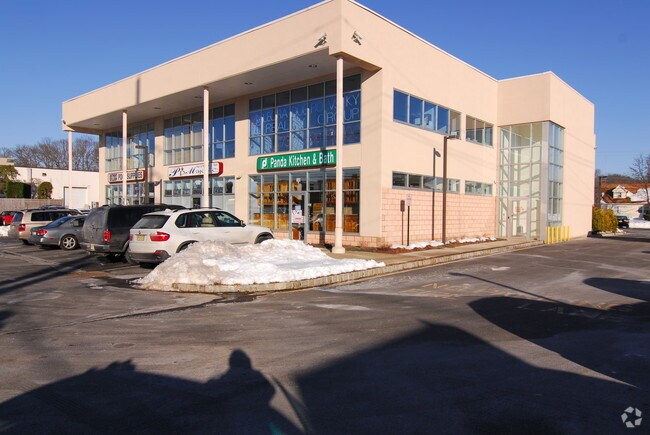
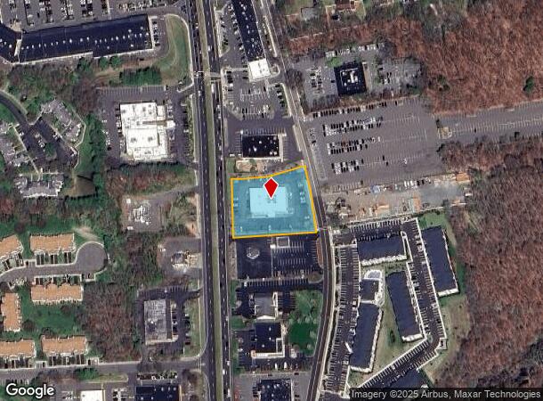
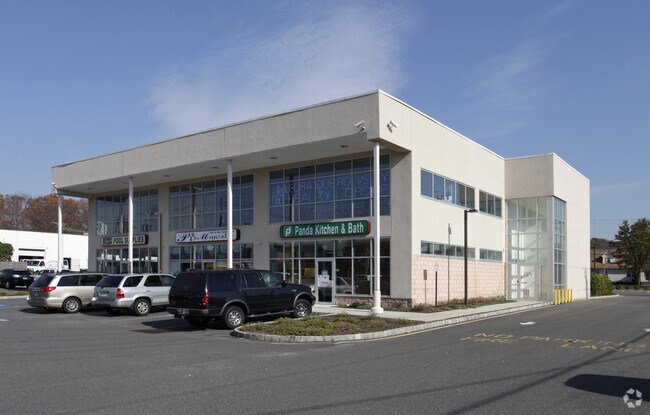
Property Record
348 Highway 9, Manasquan, NJ 08736
NEARBY LISTINGS FOR SALE OR LEASE
Property Detail
348 Highway 9
New York-Jersey City-White Plains, NY-NJ
Incl
28-00008-0000-00007-02
INCL BLK 8 LOTS 7-A & 7-B
Regionalshoppingcenterormallwithanchorstore
Monmouth
X
New Jersey
34025C0141F
7.2
2024
1.27 AC
2025
Western Monmouth
808800
Northern New Jersey
DEMOGRAPHICS near 348 Highway 9
1 Mile
3 Mile
5 Mile
2024 Total Population
6,048
49,667
111,406
2029 Population
5,955
49,052
110,483
Pop Growth 2024-2029
(1.54%)
(1.24%)
(0.83%)
Average Age
42
44
43
2024 Total Households
1,978
17,027
38,795
HH Growth 2024-2029
(1.67%)
(1.28%)
(0.91%)
Median Household Inc
$170,778
$148,297
$130,916
Avg Household Size
3.00
2.80
2.80
2024 Avg HH Vehicles
2.00
2.00
2.00
Median Home Value
$565,416
$601,114
$573,587
Median Year Built
1976
1981
1984
Nearby Places
Map Layers
Map Styles
 Street
 Aerial
- Restaurants
- Banks
- Shops
- Fitness
- Groceries
PUBLIC TRANSPORTATION
COMMUTER RAIL
Aberdeen Matawan (North Jersey Coast Line - NJ Transit Commuter Rail (NJ Transit))
DRIVE
WALK
Distance
Aberdeen Matawan (North Jersey Coast Line - NJ Transit Commuter Rail (NJ Transit))
16 min
9.2 mi
AIRPORT
Newark Liberty International
DRIVE
WALK
Distance
Newark Liberty International
44 min
36.3 mi
Trenton Mercer
DRIVE
WALK
Distance
Trenton Mercer
55 min
36.6 mi
Freight Ports
New York Container Terminal
DRIVE
WALK
Distance
New York Container Terminal
37 min
28.5 mi
Nearby Properties
Address
Land Use
TOTAL SIZE
Lot Size
Zoning
Address
Land Use
TOTAL SIZE
Lot Size
Zoning
56.99 AC
C1
Address
Land Use
TOTAL SIZE
Lot Size
Zoning
12.10 AC
PB
Address
Land Use
TOTAL SIZE
Lot Size
Zoning
25.27 AC
C1
Address
Land Use
TOTAL SIZE
Lot Size
Zoning
212,031 SF
23.97 AC
C3
Address
Land Use
TOTAL SIZE
Lot Size
Zoning
223,463 SF
41.75 AC
C-3
Address
Land Use
TOTAL SIZE
Lot Size
Zoning
48,451 SF
12.17 AC
B-10
Address
Land Use
TOTAL SIZE
Lot Size
Zoning
23.08 AC
PB
Address
Land Use
TOTAL SIZE
Lot Size
Zoning
12,614 SF
32.36 AC
IOR
Address
Land Use
TOTAL SIZE
Lot Size
Zoning
54,065 SF
19.07 AC
CM3A
Address
Land Use
TOTAL SIZE
Lot Size
Zoning
6.97 AC
C2
Address
Land Use
TOTAL SIZE
Lot Size
Zoning
1,800 SF
83.93 AC
R120
Address
Land Use
TOTAL SIZE
Lot Size
Zoning
8.15 AC
C2-M
Address
Land Use
TOTAL SIZE
Lot Size
Zoning
27,535 SF
7.03 AC
CM3A
Address
Land Use
TOTAL SIZE
Lot Size
Zoning
16,496 SF
10.87 AC
CM3A
Address
Land Use
TOTAL SIZE
Lot Size
Zoning
30.80 AC
CF
Address
Land Use
TOTAL SIZE
Lot Size
Zoning
28,383 SF
20.77 AC
B10
Address
Land Use
TOTAL SIZE
Lot Size
Zoning
58,674 SF
44 SF
C-3
Address
Land Use
TOTAL SIZE
Lot Size
Zoning
58,024 SF
9.45 AC
C2
Address
Land Use
TOTAL SIZE
Lot Size
Zoning
10.86 AC
C-3
Address
Land Use
TOTAL SIZE
Lot Size
Zoning
98,000 SF
7.52 AC
7663
Address
Land Use
TOTAL SIZE
Lot Size
Zoning
7,356 SF
43.47 AC
R-E
Address
Land Use
TOTAL SIZE
Lot Size
Zoning
65,708 SF
13.65 AC
C-5
Address
Land Use
TOTAL SIZE
Lot Size
Zoning
17,342 SF
64.55 AC
ROS
Address
Land Use
TOTAL SIZE
Lot Size
Zoning
84,626 SF
15.37 AC
R120
Address
Land Use
TOTAL SIZE
Lot Size
Zoning
41,632 SF
6.26 AC
OB01
Address
Land Use
TOTAL SIZE
Lot Size
Zoning
6.37 AC
C2
Address
Land Use
TOTAL SIZE
Lot Size
Zoning
21.35 AC
CF
Address
Land Use
TOTAL SIZE
Lot Size
Zoning
18 AC
PB
Address
Land Use
TOTAL SIZE
Lot Size
Zoning
16.46 AC
PB
Address
Land Use
TOTAL SIZE
Lot Size
Zoning
6.68 AC
C3
The World's #1 Commercial Real Estate Marketplace
Connect with us
© 2025 CoStar Group
The information above has been obtained from sources believed reliable. While we do not doubt its accuracy we have not verified it and make no guarantee, warranty or representation about it. It is your responsibility to independently confirm its accuracy and completeness. Any projections, opinions, assumptions, or estimates used are for example only and do not represent the current or future performance of the property. The value of this transaction to you depends on tax and other factors which should be evaluated by your tax, financial, and legal advisors. You and your advisors should conduct a careful, independent investigation of the property to determine to your satisfaction the suitability of the property for your needs.