Property Record
0 Corona Rd, Petaluma, CA 94952
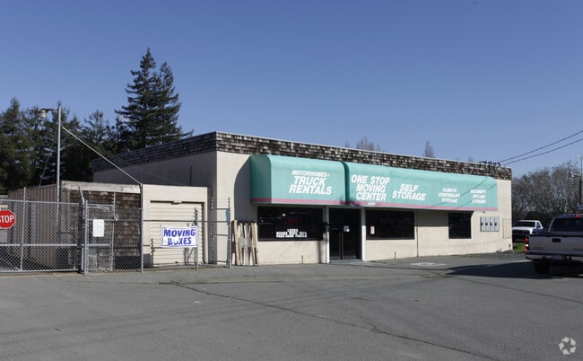
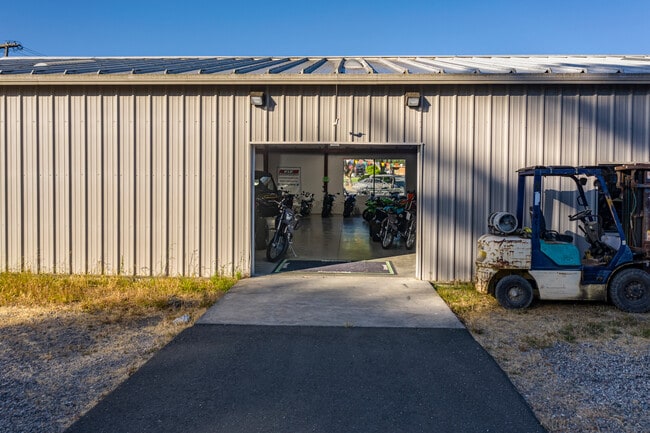

This Property Is For Sale
NEARBY LISTINGS FOR SALE OR LEASE
Property Detail
0 Corona Rd
Santa Rosa, CA
Roblar De La Miseria Rho
048-072-016
82 NOT PREVIOUSLY ASSESSED PT FR RD RES#69029
Parkinglot
Sonoma
AE
California
06097C0893F
0.34 AC
2024
Petaluma/Cotati/Rohnert
2025
North Bay/Santa Rosa
151000
DEMOGRAPHICS near 0 Corona Rd
1 Mile
3 Mile
5 Mile
2024 Total Population
5,002
49,391
78,042
2029 Population
4,880
48,543
76,739
Pop Growth 2024-2029
(2.44%)
(1.72%)
(1.67%)
Average Age
45
44
43
2024 Total Households
2,086
19,591
30,243
HH Growth 2024-2029
(2.49%)
(1.73%)
(1.70%)
Median Household Inc
$99,743
$106,532
$109,341
Avg Household Size
2.40
2.50
2.50
2024 Avg HH Vehicles
2.00
2.00
2.00
Median Home Value
$679,836
$790,754
$794,580
Median Year Built
1987
1977
1980
Nearby Places
Map Layers
Map Styles
 Street
 Aerial
- Restaurants
- Banks
- Shops
- Fitness
- Groceries
PUBLIC TRANSPORTATION
COMMUTER RAIL
Smart Petaluma North (Main Line - Sonoma Marin Area Rail Transit)
DRIVE
WALK
Distance
Smart Petaluma North (Main Line - Sonoma Marin Area Rail Transit)
1 min
12 min
0.6 mi
Petaluma Downtown Smart (Main Line - Sonoma Marin Area Rail Transit)
DRIVE
WALK
Distance
Petaluma Downtown Smart (Main Line - Sonoma Marin Area Rail Transit)
4 min
2.3 mi
AIRPORT
Charles M Schulz - Sonoma County
DRIVE
WALK
Distance
Charles M Schulz - Sonoma County
28 min
21.9 mi
Freight Ports
Port of Richmond
DRIVE
WALK
Distance
Port of Richmond
49 min
35.4 mi
Nearby Properties
Address
Land Use
TOTAL SIZE
Lot Size
Zoning
Address
Land Use
TOTAL SIZE
Lot Size
Zoning
231,609 SF
8.05 AC
Address
Land Use
TOTAL SIZE
Lot Size
Zoning
121,876 SF
16.14 AC
Address
Land Use
TOTAL SIZE
Lot Size
Zoning
150,025 SF
1.48 AC
Address
Land Use
TOTAL SIZE
Lot Size
Zoning
165,541 SF
12.61 AC
Address
Land Use
TOTAL SIZE
Lot Size
Zoning
149,242 SF
5.40 AC
CITYPE
Address
Land Use
TOTAL SIZE
Lot Size
Zoning
137,270 SF
10.04 AC
Address
Land Use
TOTAL SIZE
Lot Size
Zoning
94,107 SF
2.66 AC
Address
Land Use
TOTAL SIZE
Lot Size
Zoning
89,944 SF
14.63 AC
CITYPE
Address
Land Use
TOTAL SIZE
Lot Size
Zoning
170,524 SF
14.53 AC
Address
Land Use
TOTAL SIZE
Lot Size
Zoning
1.18 AC
Address
Land Use
TOTAL SIZE
Lot Size
Zoning
151,942 SF
5.85 AC
Address
Land Use
TOTAL SIZE
Lot Size
Zoning
80,392 SF
7.13 AC
Address
Land Use
TOTAL SIZE
Lot Size
Zoning
195,837 SF
16.32 AC
PCD
Address
Land Use
TOTAL SIZE
Lot Size
Zoning
85,582 SF
2.61 AC
CITYPE
Address
Land Use
TOTAL SIZE
Lot Size
Zoning
Address
Land Use
TOTAL SIZE
Lot Size
Zoning
71,220 SF
7.31 AC
CITYPE
Address
Land Use
TOTAL SIZE
Lot Size
Zoning
138,520 SF
10.36 AC
ML
Address
Land Use
TOTAL SIZE
Lot Size
Zoning
0.96 AC
MG
Address
Land Use
TOTAL SIZE
Lot Size
Zoning
70,110 SF
1.11 AC
CITYPE
Address
Land Use
TOTAL SIZE
Lot Size
Zoning
93,700 SF
6.02 AC
ML
Address
Land Use
TOTAL SIZE
Lot Size
Zoning
41,302 SF
1.43 AC
CITYPE
Address
Land Use
TOTAL SIZE
Lot Size
Zoning
81,975 SF
5 AC
Address
Land Use
TOTAL SIZE
Lot Size
Zoning
88,482 SF
7.29 AC
Address
Land Use
TOTAL SIZE
Lot Size
Zoning
64,568 SF
0.87 AC
Address
Land Use
TOTAL SIZE
Lot Size
Zoning
83,880 SF
5 AC
ML
Address
Land Use
TOTAL SIZE
Lot Size
Zoning
49,549 SF
4.02 AC
CITYPE
Address
Land Use
TOTAL SIZE
Lot Size
Zoning
43,050 SF
1.38 AC
Address
Land Use
TOTAL SIZE
Lot Size
Zoning
7.52 AC
Address
Land Use
TOTAL SIZE
Lot Size
Zoning
112,240 SF
6.30 AC
PUD
The World's #1 Commercial Real Estate Marketplace
Connect with us
© 2025 CoStar Group
The information above has been obtained from sources believed reliable. While we do not doubt its accuracy we have not verified it and make no guarantee, warranty or representation about it. It is your responsibility to independently confirm its accuracy and completeness. Any projections, opinions, assumptions, or estimates used are for example only and do not represent the current or future performance of the property. The value of this transaction to you depends on tax and other factors which should be evaluated by your tax, financial, and legal advisors. You and your advisors should conduct a careful, independent investigation of the property to determine to your satisfaction the suitability of the property for your needs.