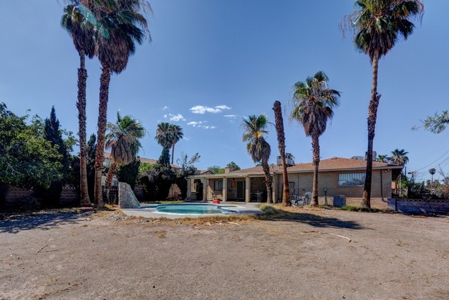
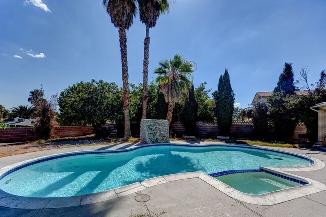
Property Record
3485 Shamrock Ave, Las Vegas, NV 89120

NEARBY LISTINGS FOR SALE OR LEASE
Property Detail
3485 Shamrock Ave
Las Vegas-Henderson-Paradise, NV
Parcel Map File 13 Page 8
161-30-204-005
Clark
Sfr
Nevada
X
0.43 AC
32003C2580F
Paradise Valley East
4,098 SF
Las Vegas
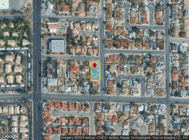
DEMOGRAPHICS near 3485 Shamrock Ave
1 Mile
3 Mile
5 Mile
2024 Total Population
18,323
156,950
430,820
2029 Population
19,612
167,309
461,626
Pop Growth 2024-2029
+ 7.03%
+ 6.60%
+ 7.15%
Average Age
43
40
40
2024 Total Households
7,187
63,204
173,032
HH Growth 2024-2029
+ 7.01%
+ 6.61%
+ 7.23%
Median Household Inc
$60,586
$48,580
$51,242
Avg Household Size
2.50
2.40
2.40
2024 Avg HH Vehicles
2.00
2.00
2.00
Median Home Value
$354,004
$311,427
$321,870
Median Year Built
1980
1983
1989
Nearby Places
Map Layers
Map Styles
 Street
 Aerial
- Restaurants
- Banks
- Shops
- Fitness
- Groceries
PUBLIC TRANSPORTATION
AIRPORT
Harry Reid International
DRIVE
WALK
Distance
Harry Reid International
8 min
3.9 mi
Boulder City Municipal
DRIVE
WALK
Distance
Boulder City Municipal
27 min
20.1 mi
Freight Ports
Port of Long Beach
DRIVE
WALK
Distance
Port of Long Beach
316 min
279.9 mi
SALE & LEASE HISTORY
LISTING DATE
SALE/LEASE

Sep 08, 2017
For Sale
Feb 14, 2023
For Sale
Nearby Properties
Address
Land Use
TOTAL SIZE
Lot Size
Zoning
Address
Land Use
TOTAL SIZE
Lot Size
Zoning
265,609 SF
47.36 AC
H1
Address
Land Use
TOTAL SIZE
Lot Size
Zoning
138.07 AC
PF
Address
Land Use
TOTAL SIZE
Lot Size
Zoning
345,133 SF
27.01 AC
H1
Address
Land Use
TOTAL SIZE
Lot Size
Zoning
44.69 AC
PF
Address
Land Use
TOTAL SIZE
Lot Size
Zoning
72.03 AC
PF
Address
Land Use
TOTAL SIZE
Lot Size
Zoning
399,206 SF
22.06 AC
MD
Address
Land Use
TOTAL SIZE
Lot Size
Zoning
410,084 SF
16.74 AC
RH24
Address
Land Use
TOTAL SIZE
Lot Size
Zoning
95,928 SF
3.71 AC
C:U-V
Address
Land Use
TOTAL SIZE
Lot Size
Zoning
239,785 SF
2.20 AC
C:R-5
Address
Land Use
TOTAL SIZE
Lot Size
Zoning
148.64 AC
PF
Address
Land Use
TOTAL SIZE
Lot Size
Zoning
513,085 SF
53.27 AC
C2
Address
Land Use
TOTAL SIZE
Lot Size
Zoning
100.25 AC
RS1
Address
Land Use
TOTAL SIZE
Lot Size
Zoning
8,891 SF
11.59 AC
Address
Land Use
TOTAL SIZE
Lot Size
Zoning
198.15 AC
PF
Address
Land Use
TOTAL SIZE
Lot Size
Zoning
38,764 SF
12.66 AC
H1
Address
Land Use
TOTAL SIZE
Lot Size
Zoning
4,460 SF
27.52 AC
Address
Land Use
TOTAL SIZE
Lot Size
Zoning
56,526 SF
12.44 AC
C2
Address
Land Use
TOTAL SIZE
Lot Size
Zoning
152.76 AC
PF
Address
Land Use
TOTAL SIZE
Lot Size
Zoning
43.37 AC
RS1
Address
Land Use
TOTAL SIZE
Lot Size
Zoning
6,659 SF
6.05 AC
H1
Address
Land Use
TOTAL SIZE
Lot Size
Zoning
100.43 AC
PF
Address
Land Use
TOTAL SIZE
Lot Size
Zoning
4.18 AC
PF
Address
Land Use
TOTAL SIZE
Lot Size
Zoning
303,540 SF
4.99 AC
Address
Land Use
TOTAL SIZE
Lot Size
Zoning
554,741 SF
9.79 AC
C:MLZ
Address
Land Use
TOTAL SIZE
Lot Size
Zoning
213,048 SF
13.60 AC
Address
Land Use
TOTAL SIZE
Lot Size
Zoning
13,589 SF
56.80 AC
PF
Address
Land Use
TOTAL SIZE
Lot Size
Zoning
7,304 SF
12.58 AC
R4
Address
Land Use
TOTAL SIZE
Lot Size
Zoning
334,698 SF
18.44 AC
MD
Address
Land Use
TOTAL SIZE
Lot Size
Zoning
3,040 SF
16.76 AC
R4
Address
Land Use
TOTAL SIZE
Lot Size
Zoning
6,548 SF
15.75 AC
RH24
The World's #1 Commercial Real Estate Marketplace
Connect with us
© 2025 CoStar Group
The information above has been obtained from sources believed reliable. While we do not doubt its accuracy we have not verified it and make no guarantee, warranty or representation about it. It is your responsibility to independently confirm its accuracy and completeness. Any projections, opinions, assumptions, or estimates used are for example only and do not represent the current or future performance of the property. The value of this transaction to you depends on tax and other factors which should be evaluated by your tax, financial, and legal advisors. You and your advisors should conduct a careful, independent investigation of the property to determine to your satisfaction the suitability of the property for your needs.