Property Record
34880 Yucaipa Blvd, Yucaipa, CA 92399

NEARBY LISTINGS FOR SALE OR LEASE
-
-
View all Yucaipa listings for sale on LoopNet.com
Property Detail
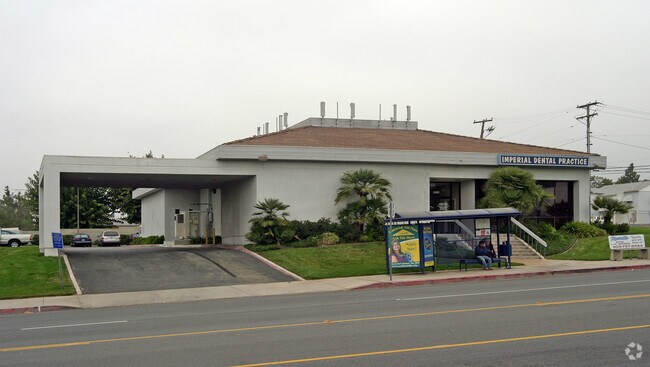
34880 Yucaipa Blvd
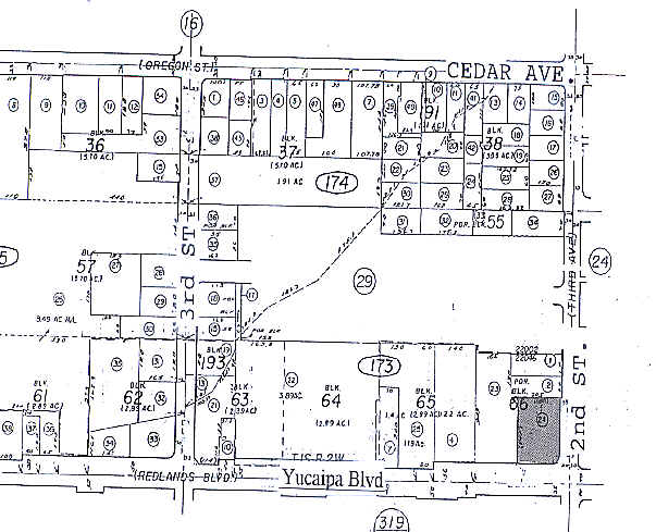
0303-173-24
Revised Map Of Yucaipa City
Medicalbuilding
REVISED MAP OF YUCAIPA CITY THAT PTN BLK 66 BEG AT THE INTERSECTION OF C/L YUCAIPA BLVD AND C/L SECOND ST TH W ALG C/L YUCAIPA BLVD 180 FT TH N 229 FT TH E 180 FT TO PT IN C/L SECOND ST TH S 229 FT TO POB EX STAND EX ADD ST PER DOC RECORDED 3-26-82 #
X
San Bernardino
06071C8745H
California
2024
0.60 AC
2025
Redlands/Loma Linda
008800
Inland Empire (California)
5,401 SF
Riverside-San Bernardino-Ontario, CA
DEMOGRAPHICS near 34880 Yucaipa Blvd
1 Mile
3 Mile
5 Mile
2024 Total Population
17,477
57,476
73,729
2029 Population
17,949
58,868
75,837
Pop Growth 2024-2029
+ 2.70%
+ 2.42%
+ 2.86%
Average Age
39
40
40
2024 Total Households
6,420
20,619
26,252
HH Growth 2024-2029
+ 2.74%
+ 2.42%
+ 2.77%
Median Household Inc
$68,050
$79,095
$83,407
Avg Household Size
2.70
2.70
2.80
2024 Avg HH Vehicles
2.00
2.00
2.00
Median Home Value
$398,484
$441,044
$455,681
Median Year Built
1969
1976
1978
Nearby Places
Map Layers
Map Styles
 Street
 Aerial
- Restaurants
- Banks
- Shops
- Fitness
- Groceries
PUBLIC TRANSPORTATION
COMMUTER RAIL
DRIVE
WALK
Distance
14 min
8.4 mi
DRIVE
WALK
Distance
16 min
9.5 mi
AIRPORT
Ontario International
DRIVE
WALK
Distance
Ontario International
45 min
34.0 mi
Palm Springs International
DRIVE
WALK
Distance
Palm Springs International
52 min
42.4 mi
Nearby Properties
Address
Land Use
TOTAL SIZE
Lot Size
Zoning
Address
Land Use
TOTAL SIZE
Lot Size
Zoning
369,838 SF
19.32 AC
Address
Land Use
TOTAL SIZE
Lot Size
Zoning
102,506 SF
4.47 AC
Address
Land Use
TOTAL SIZE
Lot Size
Zoning
82,694 SF
3.41 AC
Address
Land Use
TOTAL SIZE
Lot Size
Zoning
5.47 AC
Address
Land Use
TOTAL SIZE
Lot Size
Zoning
79,299 SF
5.04 AC
Address
Land Use
TOTAL SIZE
Lot Size
Zoning
67,686 SF
4.16 AC
Address
Land Use
TOTAL SIZE
Lot Size
Zoning
56,491 SF
7.50 AC
Address
Land Use
TOTAL SIZE
Lot Size
Zoning
56,491 SF
3.39 AC
Address
Land Use
TOTAL SIZE
Lot Size
Zoning
22,308 SF
1.87 AC
Address
Land Use
TOTAL SIZE
Lot Size
Zoning
24,510 SF
6.88 AC
Address
Land Use
TOTAL SIZE
Lot Size
Zoning
49,952 SF
4.34 AC
Address
Land Use
TOTAL SIZE
Lot Size
Zoning
29,387 SF
3.21 AC
Address
Land Use
TOTAL SIZE
Lot Size
Zoning
27,627 SF
5.07 AC
Address
Land Use
TOTAL SIZE
Lot Size
Zoning
42,634 SF
1.91 AC
Address
Land Use
TOTAL SIZE
Lot Size
Zoning
111,182 SF
3.11 AC
Address
Land Use
TOTAL SIZE
Lot Size
Zoning
15,980 SF
1.56 AC
Address
Land Use
TOTAL SIZE
Lot Size
Zoning
44,046 SF
3.77 AC
Address
Land Use
TOTAL SIZE
Lot Size
Zoning
33,000 SF
2.96 AC
Address
Land Use
TOTAL SIZE
Lot Size
Zoning
41,005 SF
3.27 AC
MIX
Address
Land Use
TOTAL SIZE
Lot Size
Zoning
78,309 SF
7.09 AC
Address
Land Use
TOTAL SIZE
Lot Size
Zoning
29,996 SF
1.86 AC
Address
Land Use
TOTAL SIZE
Lot Size
Zoning
73,670 SF
4.49 AC
Address
Land Use
TOTAL SIZE
Lot Size
Zoning
9.71 AC
Address
Land Use
TOTAL SIZE
Lot Size
Zoning
1,970 SF
6.27 AC
Address
Land Use
TOTAL SIZE
Lot Size
Zoning
41,040 SF
4.70 AC
Address
Land Use
TOTAL SIZE
Lot Size
Zoning
23,227 SF
1.81 AC
Address
Land Use
TOTAL SIZE
Lot Size
Zoning
18,800 SF
4.07 AC
CC
Address
Land Use
TOTAL SIZE
Lot Size
Zoning
14,738 SF
1.49 AC
C1
Address
Land Use
TOTAL SIZE
Lot Size
Zoning
45,862 SF
4.51 AC
Address
Land Use
TOTAL SIZE
Lot Size
Zoning
44,864 SF
5.34 AC
The World's #1 Commercial Real Estate Marketplace
Connect with us
© 2025 CoStar Group
The information above has been obtained from sources believed reliable. While we do not doubt its accuracy we have not verified it and make no guarantee, warranty or representation about it. It is your responsibility to independently confirm its accuracy and completeness. Any projections, opinions, assumptions, or estimates used are for example only and do not represent the current or future performance of the property. The value of this transaction to you depends on tax and other factors which should be evaluated by your tax, financial, and legal advisors. You and your advisors should conduct a careful, independent investigation of the property to determine to your satisfaction the suitability of the property for your needs.