Property Record
349 E 3Rd St, North Bend, WA 98045
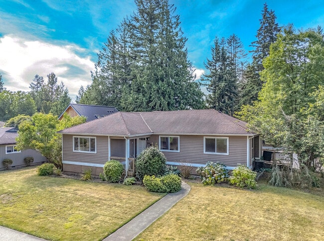
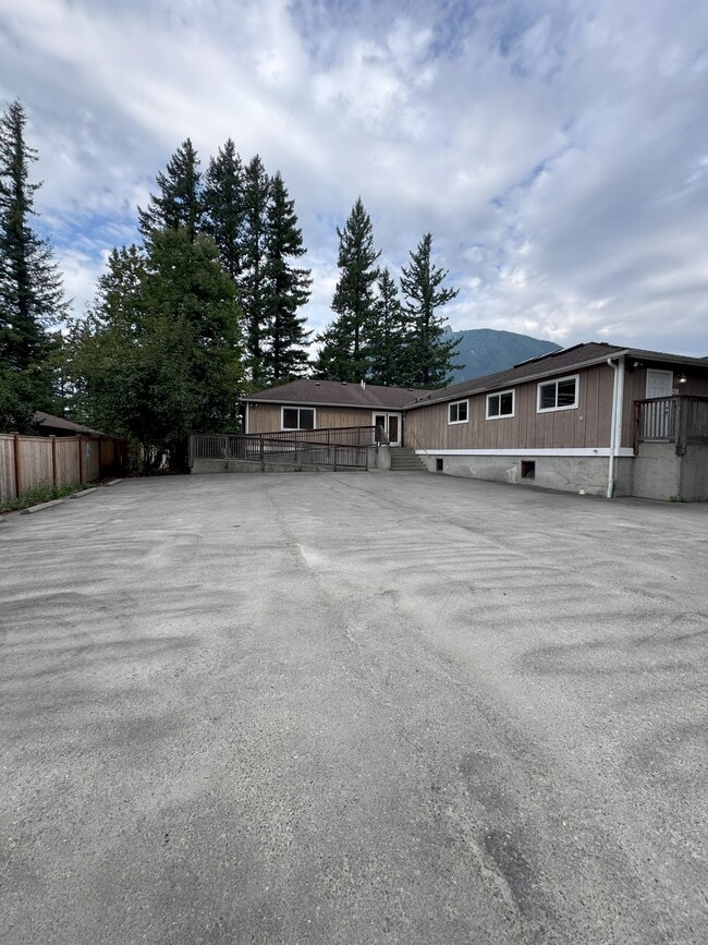
This Property Is For Sale
NEARBY LISTINGS FOR SALE OR LEASE
-
-
View all North Bend listings for sale on LoopNet.com
Property Detail
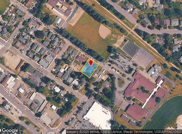
349 E 3Rd St
Seattle-Tacoma-Bellevue, WA
Gardiners Add To North Bend
270060-0135
King
Sfr
Washington
AO
0.32 AC
53033C1057K
E King County
3,395 SF
Seattle/Puget Sound
DEMOGRAPHICS near 349 E 3Rd St
1 Mile
3 Mile
5 Mile
2024 Total Population
5,473
14,430
25,302
2029 Population
5,779
15,126
26,370
Pop Growth 2024-2029
+ 5.59%
+ 4.82%
+ 4.22%
Average Age
41
41
40
2024 Total Households
2,077
5,350
9,081
HH Growth 2024-2029
+ 5.44%
+ 4.73%
+ 4.18%
Median Household Inc
$146,652
$163,866
$167,155
Avg Household Size
2.60
2.70
2.70
2024 Avg HH Vehicles
2.00
2.00
2.00
Median Home Value
$927,595
$875,676
$876,492
Median Year Built
1987
1988
1990
Nearby Places
Map Layers
Map Styles
 Street
 Aerial
- Restaurants
- Banks
- Shops
- Fitness
- Groceries
PUBLIC TRANSPORTATION
AIRPORT
Seattle-Tacoma International
DRIVE
WALK
Distance
Seattle-Tacoma International
50 min
36.0 mi
Seattle Paine Field International
DRIVE
WALK
Distance
Seattle Paine Field International
63 min
47.2 mi
Freight Ports
Port of Seattle
DRIVE
WALK
Distance
Port of Seattle
45 min
32.7 mi
Nearby Properties
Address
Land Use
TOTAL SIZE
Lot Size
Zoning
Address
Land Use
TOTAL SIZE
Lot Size
Zoning
355,000 SF
26.61 AC
RC
Address
Land Use
TOTAL SIZE
Lot Size
Zoning
333,889 SF
13.32 AC
HDR
Address
Land Use
TOTAL SIZE
Lot Size
Zoning
400,644 SF
34.17 AC
BP
Address
Land Use
TOTAL SIZE
Lot Size
Zoning
970 SF
5.40 AC
NMU
Address
Land Use
TOTAL SIZE
Lot Size
Zoning
58,835 SF
1.92 AC
HDR
Address
Land Use
TOTAL SIZE
Lot Size
Zoning
36,925 SF
23.53 AC
IC
Address
Land Use
TOTAL SIZE
Lot Size
Zoning
42,816 SF
0.71 AC
HDR
Address
Land Use
TOTAL SIZE
Lot Size
Zoning
29,856 SF
0.98 AC
DC
Address
Land Use
TOTAL SIZE
Lot Size
Zoning
25,836 SF
2.88 AC
DC
Address
Land Use
TOTAL SIZE
Lot Size
Zoning
32,200 SF
1.68 AC
IC
Address
Land Use
TOTAL SIZE
Lot Size
Zoning
7,000 SF
6.12 AC
NB
Address
Land Use
TOTAL SIZE
Lot Size
Zoning
30,960 SF
1.38 AC
HDR
Address
Land Use
TOTAL SIZE
Lot Size
Zoning
53,192 SF
6.11 AC
NB
Address
Land Use
TOTAL SIZE
Lot Size
Zoning
1,060 SF
10.86 AC
NMU
Address
Land Use
TOTAL SIZE
Lot Size
Zoning
2,050 SF
2.10 AC
NMU
Address
Land Use
TOTAL SIZE
Lot Size
Zoning
29,764 SF
16.90 AC
OP
Address
Land Use
TOTAL SIZE
Lot Size
Zoning
1,760 SF
4.82 AC
POSPF
Address
Land Use
TOTAL SIZE
Lot Size
Zoning
42,723 SF
15.56 AC
POSPF
Address
Land Use
TOTAL SIZE
Lot Size
Zoning
28,750 SF
0.74 AC
DC
Address
Land Use
TOTAL SIZE
Lot Size
Zoning
30,457 SF
8.40 AC
POSPF
Address
Land Use
TOTAL SIZE
Lot Size
Zoning
52,491 SF
5.05 AC
IMU
Address
Land Use
TOTAL SIZE
Lot Size
Zoning
54,000 SF
9.19 AC
RC
Address
Land Use
TOTAL SIZE
Lot Size
Zoning
19,080 SF
1.82 AC
RC
Address
Land Use
TOTAL SIZE
Lot Size
Zoning
12,280 SF
2.63 AC
DC
Address
Land Use
TOTAL SIZE
Lot Size
Zoning
63,555 SF
45.09 AC
RC
Address
Land Use
TOTAL SIZE
Lot Size
Zoning
40,724 SF
3.42 AC
DC
Address
Land Use
TOTAL SIZE
Lot Size
Zoning
40,600 SF
3.21 AC
EP
Address
Land Use
TOTAL SIZE
Lot Size
Zoning
33,595 SF
3.44 AC
EP
Address
Land Use
TOTAL SIZE
Lot Size
Zoning
14,952 SF
0.79 AC
DC
The World's #1 Commercial Real Estate Marketplace
Connect with us
© 2026 CoStar Group
The information above has been obtained from sources believed reliable. While we do not doubt its accuracy we have not verified it and make no guarantee, warranty or representation about it. It is your responsibility to independently confirm its accuracy and completeness. Any projections, opinions, assumptions, or estimates used are for example only and do not represent the current or future performance of the property. The value of this transaction to you depends on tax and other factors which should be evaluated by your tax, financial, and legal advisors. You and your advisors should conduct a careful, independent investigation of the property to determine to your satisfaction the suitability of the property for your needs.