Property Record
349 Margie Dr, Warner Robins, GA 31088
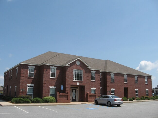


Property Detail
349 Margie Dr
0W78D0130000
PARCEL H-6 OSIGIAN CORNERS PH 3
Officebuilding
HOUSTON
C2
Georgia
B and X Area of moderate flood hazard, usually the area between the limits of the 100-year and 500-year floods.
95
2025
1.10 AC
2025
Perry/Warner Robins
021117
Other Market Areas
5,942 SF
Warner Robins, GA
NEARBY LISTINGS FOR SALE OR LEASE
DEMOGRAPHICS near 349 Margie Dr
1 mile
3 mile
5 mile
2025 Total Population
5,355
51,556
115,758
2030 Population
5,681
54,121
121,412
Pop Growth 2025-2030
+ 6.09%
+ 4.98%
+ 4.88%
Average Age
40
39
38
2025 Total Households
2,426
20,662
45,304
HH Growth 2025-2030
+ 6.06%
+ 4.99%
+ 4.93%
Median Household Inc
$62,188
$73,254
$69,826
Avg Household Size
2.20
2.50
2.50
2025 Avg HH Vehicles
2.00
2.00
2.00
Median Home Value
$169,815
$195,830
$194,748
Median Year Built
1997
1994
1991
Nearby Places
Map Layers
Map Styles
 Street
 Aerial
Layers
 Traffic
 Biking
Places
Listings with unknown addresses are not visible on the map
- Restaurants
- Banks
- Shops
- Fitness
- Groceries
SALE & LEASE HISTORY
LISTING DATE
SALE/LEASE

Sep 25, 2016
For Lease
Nov 23, 2016
For Sale
Nov 23, 2016
For Lease
Nov 14, 2016
For Sale
Jun 06, 2025
For Lease
Feb 17, 2017
For Lease
Nearby Properties
Address
Land Use
TOTAL SIZE
Lot Size
Zoning
Address
Land Use
TOTAL SIZE
Lot Size
Zoning
503,585 SF
61.05 AC
C-2, WR
Address
Land Use
TOTAL SIZE
Lot Size
Zoning
5,648 SF
49.72 AC
R4
Address
Land Use
TOTAL SIZE
Lot Size
Zoning
18,954 SF
20 AC
C2
Address
Land Use
TOTAL SIZE
Lot Size
Zoning
9,600 SF
24.25 AC
C-H
Address
Land Use
TOTAL SIZE
Lot Size
Zoning
37,908 SF
19.79 AC
C2
Address
Land Use
TOTAL SIZE
Lot Size
Zoning
3,960 SF
22.93 AC
R4
Address
Land Use
TOTAL SIZE
Lot Size
Zoning
61,158 SF
26.31 AC
PUD
Address
Land Use
TOTAL SIZE
Lot Size
Zoning
5,640 SF
28 AC
PDE
Address
Land Use
TOTAL SIZE
Lot Size
Zoning
338,708 SF
28.28 AC
M-2 WR
Address
Land Use
TOTAL SIZE
Lot Size
Zoning
5,640 SF
24 AC
C2
Address
Land Use
TOTAL SIZE
Lot Size
Zoning
26,271 SF
17.43 AC
C2
Address
Land Use
TOTAL SIZE
Lot Size
Zoning
21,476 SF
17.41 AC
R4
Address
Land Use
TOTAL SIZE
Lot Size
Zoning
488,964 SF
49.90 AC
C2
Address
Land Use
TOTAL SIZE
Lot Size
Zoning
94,820 SF
18.66 AC
C2
Address
Land Use
TOTAL SIZE
Lot Size
Zoning
223,599 SF
22.40 AC
C2
Address
Land Use
TOTAL SIZE
Lot Size
Zoning
100,500 SF
19.74 AC
R2
Address
Land Use
TOTAL SIZE
Lot Size
Zoning
2,551 SF
17.38 AC
R4 C2
Address
Land Use
TOTAL SIZE
Lot Size
Zoning
100,500 SF
19.64 AC
R2
Address
Land Use
TOTAL SIZE
Lot Size
Zoning
2,080 SF
15.62 AC
R4
Address
Land Use
TOTAL SIZE
Lot Size
Zoning
560 SF
24.73 AC
R4
Address
Land Use
TOTAL SIZE
Lot Size
Zoning
225,751 SF
100 AC
M-1, WR
Address
Land Use
TOTAL SIZE
Lot Size
Zoning
304,246 SF
23.11 AC
C2
Address
Land Use
TOTAL SIZE
Lot Size
Zoning
63,274 SF
40.27 AC
C-2, WR
Address
Land Use
TOTAL SIZE
Lot Size
Zoning
132,850 SF
24.05 AC
C2
Address
Land Use
TOTAL SIZE
Lot Size
Zoning
234,239 SF
24.71 AC
C2
Address
Land Use
TOTAL SIZE
Lot Size
Zoning
158,300 SF
29.99 AC
R1
Address
Land Use
TOTAL SIZE
Lot Size
Zoning
76,751 SF
26.32 AC
R1
Address
Land Use
TOTAL SIZE
Lot Size
Zoning
125,550 SF
9.82 AC
C2
Address
Land Use
TOTAL SIZE
Lot Size
Zoning
87,058 SF
8.83 AC
C2
Address
Land Use
TOTAL SIZE
Lot Size
Zoning
62,173 SF
17.70 AC
C2
The World's #1 Commercial Real Estate Marketplace
Connect with us
© 2026 CoStar Group
The information above has been obtained from sources believed reliable. While we do not doubt its accuracy we have not verified it and make no guarantee, warranty or representation about it. It is your responsibility to independently confirm its accuracy and completeness. Any projections, opinions, assumptions, or estimates used are for example only and do not represent the current or future performance of the property. The value of this transaction to you depends on tax and other factors which should be evaluated by your tax, financial, and legal advisors. You and your advisors should conduct a careful, independent investigation of the property to determine to your satisfaction the suitability of the property for your needs.