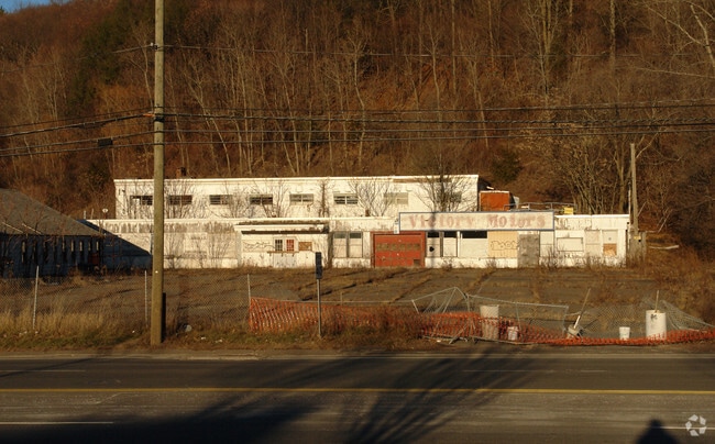
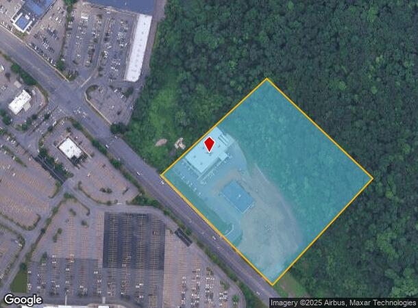
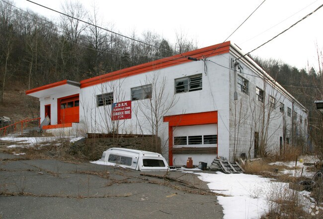
Property Record
349 New Britain Ave, Plainville, CT 06062
NEARBY LISTINGS FOR SALE OR LEASE
Property Detail
349 New Britain Ave
PLAI-000021-A000000-000003
Hartford
Storebuilding
Connecticut
X
3
09003C0487G
9.14 AC
2025
Southwest Outlying
2025
Hartford
420500
Hartford-West Hartford-East Hartford, CT
17,100 SF
DEMOGRAPHICS near 349 New Britain Ave
1 Mile
3 Mile
5 Mile
2024 Total Population
4,183
61,442
161,430
2029 Population
4,172
61,136
160,529
Pop Growth 2024-2029
(0.26%)
(0.50%)
(0.56%)
Average Age
43
41
41
2024 Total Households
1,775
25,398
65,987
HH Growth 2024-2029
(0.39%)
(0.52%)
(0.54%)
Median Household Inc
$84,229
$62,193
$67,198
Avg Household Size
2.30
2.30
2.30
2024 Avg HH Vehicles
2.00
2.00
2.00
Median Home Value
$244,299
$221,895
$239,284
Median Year Built
1966
1958
1963
Nearby Places
- Restaurants
- Banks
- Shops
- Fitness
- Groceries
PUBLIC TRANSPORTATION
COMMUTER RAIL
Berlin (Hartford Line - CONN DOT)
DRIVE
WALK
Distance
Berlin (Hartford Line - CONN DOT)
10 min
5.2 mi
Berlin Amtrak (Amtrak Hartford Line - Amtrak, Hartford Line - Amtrak, Northeast Regional - Amtrak, Valley Flyer - Amtrak)
DRIVE
WALK
Distance
Berlin Amtrak (Amtrak Hartford Line - Amtrak, Hartford Line - Amtrak, Northeast Regional - Amtrak, Valley Flyer - Amtrak)
10 min
5.2 mi
AIRPORT
Bradley International
DRIVE
WALK
Distance
Bradley International
51 min
30.5 mi
Tweed/New Haven
DRIVE
WALK
Distance
Tweed/New Haven
47 min
33.0 mi
Freight Ports
Port of New Haven
DRIVE
WALK
Distance
Port of New Haven
43 min
30.7 mi
Nearby Properties
Address
Land Use
TOTAL SIZE
Lot Size
Zoning
Address
Land Use
TOTAL SIZE
Lot Size
Zoning
268,369 SF
13.32 AC
B1
Address
Land Use
TOTAL SIZE
Lot Size
Zoning
146,740 SF
18.23 AC
TPC
Address
Land Use
TOTAL SIZE
Lot Size
Zoning
23.64 AC
S3
Address
Land Use
TOTAL SIZE
Lot Size
Zoning
131.09 AC
OP
Address
Land Use
TOTAL SIZE
Lot Size
Zoning
134,488 SF
63.26 AC
GC
Address
Land Use
TOTAL SIZE
Lot Size
Zoning
138.27 AC
S1
Address
Land Use
TOTAL SIZE
Lot Size
Zoning
64,822 SF
9.47 AC
TP
Address
Land Use
TOTAL SIZE
Lot Size
Zoning
155,161 SF
18.18 AC
S1
Address
Land Use
TOTAL SIZE
Lot Size
Zoning
2.07 AC
CBD
Address
Land Use
TOTAL SIZE
Lot Size
Zoning
112,304 SF
10.39 AC
S3
Address
Land Use
TOTAL SIZE
Lot Size
Zoning
89,544 SF
6.20 AC
S1
Address
Land Use
TOTAL SIZE
Lot Size
Zoning
182,930 SF
15.70 AC
SA
Address
Land Use
TOTAL SIZE
Lot Size
Zoning
28.47 AC
R-10
Address
Land Use
TOTAL SIZE
Lot Size
Zoning
48.09 AC
CR
Address
Land Use
TOTAL SIZE
Lot Size
Zoning
288,827 SF
24.01 AC
RI
Address
Land Use
TOTAL SIZE
Lot Size
Zoning
103,886 SF
10.47 AC
BR
Address
Land Use
TOTAL SIZE
Lot Size
Zoning
74,670 SF
4.46 AC
S2
Address
Land Use
TOTAL SIZE
Lot Size
Zoning
78,132 SF
11.76 AC
S2
Address
Land Use
TOTAL SIZE
Lot Size
Zoning
10.10 AC
RDM
Address
Land Use
TOTAL SIZE
Lot Size
Zoning
183,626 SF
12.72 AC
UI
Address
Land Use
TOTAL SIZE
Lot Size
Zoning
4.43 AC
B3/A2
Address
Land Use
TOTAL SIZE
Lot Size
Zoning
69,025 SF
10.90 AC
S2
Address
Land Use
TOTAL SIZE
Lot Size
Zoning
25.61 AC
RDM
Address
Land Use
TOTAL SIZE
Lot Size
Zoning
2 AC
OP
Address
Land Use
TOTAL SIZE
Lot Size
Zoning
502,440 SF
27.87 AC
I-2
Address
Land Use
TOTAL SIZE
Lot Size
Zoning
17.62 AC
B
Address
Land Use
TOTAL SIZE
Lot Size
Zoning
13.37 AC
B2
Address
Land Use
TOTAL SIZE
Lot Size
Zoning
4.10 AC
S3
Address
Land Use
TOTAL SIZE
Lot Size
Zoning
29.05 AC
R-20
Address
Land Use
TOTAL SIZE
Lot Size
Zoning
3,084 SF
14.90 AC
BG
The World's #1 Commercial Real Estate Marketplace
Connect with us
© 2025 CoStar Group
The information above has been obtained from sources believed reliable. While we do not doubt its accuracy we have not verified it and make no guarantee, warranty or representation about it. It is your responsibility to independently confirm its accuracy and completeness. Any projections, opinions, assumptions, or estimates used are for example only and do not represent the current or future performance of the property. The value of this transaction to you depends on tax and other factors which should be evaluated by your tax, financial, and legal advisors. You and your advisors should conduct a careful, independent investigation of the property to determine to your satisfaction the suitability of the property for your needs.