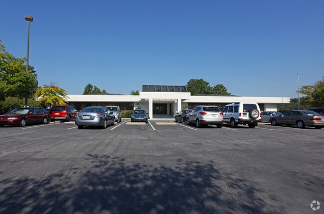
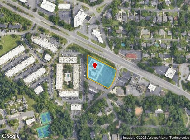
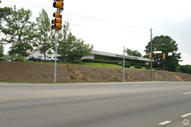
Property Record
3490 Independence Dr, Birmingham, AL 35209
Current Lease Availabilities
NEARBY LISTINGS FOR SALE OR LEASE
Property Detail
3490 Independence Dr
Birmingham-Hoover, AL
Mayfair Manor 1 S 28-18-1
28-00-18-1-014-024.000
LOT 1 MAYFAIR MANOR 1ST SECTOR
Medicalbuilding
Jefferson
X
Alabama
01073C0556J
1
2023
1.47 AC
2024
Midtown
010704
Birmingham
21,072 SF
DEMOGRAPHICS near 3490 Independence Dr
1 Mile
3 Mile
5 Mile
2024 Total Population
10,053
76,147
181,053
2029 Population
9,976
74,818
178,840
Pop Growth 2024-2029
(0.77%)
(1.75%)
(1.22%)
Average Age
35
37
38
2024 Total Households
2,969
32,443
79,373
HH Growth 2024-2029
(1.55%)
(1.62%)
(1.16%)
Median Household Inc
$119,578
$68,631
$59,284
Avg Household Size
2.40
2.10
2.10
2024 Avg HH Vehicles
2.00
2.00
2.00
Median Home Value
$612,652
$470,290
$361,752
Median Year Built
1966
1970
1972
Nearby Places
Map Layers
Map Styles
 Street
 Aerial
- Restaurants
- Banks
- Shops
- Fitness
- Groceries
PUBLIC TRANSPORTATION
COMMUTER RAIL
DRIVE
WALK
Distance
7 min
4.3 mi
AIRPORT
Birmingham-Shuttlesworth International
DRIVE
WALK
Distance
Birmingham-Shuttlesworth International
13 min
8.1 mi
Nearby Properties
Address
Land Use
TOTAL SIZE
Lot Size
Zoning
Address
Land Use
TOTAL SIZE
Lot Size
Zoning
296,284 SF
12 AC
OI
Address
Land Use
TOTAL SIZE
Lot Size
Zoning
189,447 SF
3.67 AC
B4
Address
Land Use
TOTAL SIZE
Lot Size
Zoning
978,879 SF
43.50 AC
I3
Address
Land Use
TOTAL SIZE
Lot Size
Zoning
239,334 SF
4.42 AC
B6
Address
Land Use
TOTAL SIZE
Lot Size
Zoning
261,311 SF
20.85 AC
C1
Address
Land Use
TOTAL SIZE
Lot Size
Zoning
31,980 SF
99.92 AC
I3/P
Address
Land Use
TOTAL SIZE
Lot Size
Zoning
154,474 SF
12.50 AC
R-D
Address
Land Use
TOTAL SIZE
Lot Size
Zoning
46,161 SF
1.38 AC
M1-B
Address
Land Use
TOTAL SIZE
Lot Size
Zoning
95,993 SF
3.67 AC
M1
Address
Land Use
TOTAL SIZE
Lot Size
Zoning
229,669 SF
2.75 AC
B4
Address
Land Use
TOTAL SIZE
Lot Size
Zoning
200,927 SF
19 AC
PMUD
Address
Land Use
TOTAL SIZE
Lot Size
Zoning
81,807 SF
6.30 AC
C1
Address
Land Use
TOTAL SIZE
Lot Size
Zoning
1,666 SF
1.69 AC
M1
Address
Land Use
TOTAL SIZE
Lot Size
Zoning
51,699 SF
1.31 AC
PCD-
Address
Land Use
TOTAL SIZE
Lot Size
Zoning
32,948 SF
0.48 AC
B3
Address
Land Use
TOTAL SIZE
Lot Size
Zoning
30,453 SF
0.44 AC
B2
Address
Land Use
TOTAL SIZE
Lot Size
Zoning
329,064 SF
9 AC
I3
Address
Land Use
TOTAL SIZE
Lot Size
Zoning
156,986 SF
1.29 AC
M1
Address
Land Use
TOTAL SIZE
Lot Size
Zoning
311,982 SF
30 AC
R6
Address
Land Use
TOTAL SIZE
Lot Size
Zoning
62,543 SF
1.78 AC
R-D
Address
Land Use
TOTAL SIZE
Lot Size
Zoning
97,377 SF
1.63 AC
M1
Address
Land Use
TOTAL SIZE
Lot Size
Zoning
69,981 SF
4.90 AC
B2
Address
Land Use
TOTAL SIZE
Lot Size
Zoning
33,209 SF
3.11 AC
C4B
Address
Land Use
TOTAL SIZE
Lot Size
Zoning
282,421 SF
24.33 AC
R7
Address
Land Use
TOTAL SIZE
Lot Size
Zoning
92,332 SF
8.40 AC
Address
Land Use
TOTAL SIZE
Lot Size
Zoning
331,413 SF
14.46 AC
R6
Address
Land Use
TOTAL SIZE
Lot Size
Zoning
65,685 SF
9.50 AC
B2
Address
Land Use
TOTAL SIZE
Lot Size
Zoning
265,418 SF
26.55 AC
R2
Address
Land Use
TOTAL SIZE
Lot Size
Zoning
62,516 SF
1.37 AC
I3
Address
Land Use
TOTAL SIZE
Lot Size
Zoning
52,922 SF
B3
The World's #1 Commercial Real Estate Marketplace
Connect with us
© 2025 CoStar Group
The information above has been obtained from sources believed reliable. While we do not doubt its accuracy we have not verified it and make no guarantee, warranty or representation about it. It is your responsibility to independently confirm its accuracy and completeness. Any projections, opinions, assumptions, or estimates used are for example only and do not represent the current or future performance of the property. The value of this transaction to you depends on tax and other factors which should be evaluated by your tax, financial, and legal advisors. You and your advisors should conduct a careful, independent investigation of the property to determine to your satisfaction the suitability of the property for your needs.