Property Record
3490 Paena Loop, Lihue, HI 96766


Property Detail
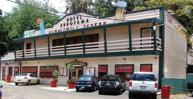
3490 Paena Loop
4-3-5-002-013-0000
POR RP 4480 LC AW 7713:2 5577 SF DES
Commercialnec
KAUAI
C-N
Hawaii
C and X Area of minimal flood hazard, usually depicted on FIRMs as above the 500-year flood level.
0.13 AC
2024
Kauai
2025
Hawaii
040500
Kapaa, HI
2,713 SF
NEARBY LISTINGS FOR SALE OR LEASE
DEMOGRAPHICS near 3490 Paena Loop
1 mile
3 mile
5 mile
2025 Total Population
2,547
16,816
17,072
2030 Population
2,590
16,812
17,073
Pop Growth 2025-2030
+ 1.69%
(0.02%)
+ 0.01%
Average Age
44
43
43
2025 Total Households
945
5,350
5,420
HH Growth 2025-2030
+ 1.27%
(0.21%)
(0.18%)
Median Household Inc
$58,134
$109,428
$109,968
Avg Household Size
2.60
3.00
3.00
2025 Avg HH Vehicles
2.00
2.00
2.00
Median Home Value
$878,260
$793,238
$793,053
Median Year Built
1985
1986
1986
Nearby Places
Map Layers
Map Styles
 Street
 Aerial
Transit
 Traffic
 Biking
Places
Listings with unknown addresses are not visible on the map
- Restaurants
- Banks
- Shops
- Fitness
- Groceries
PUBLIC TRANSPORTATION
AIRPORT
Lihue
Drive
Walk
Distance
Lihue
13 min
2.1 mi
SALE & LEASE HISTORY
LISTING DATE
SALE/LEASE

Jan 13, 2021
For Sale
Aug 21, 2019
For Sale
Nearby Properties
Address
Land Use
TOTAL SIZE
Lot Size
Zoning
Address
Land Use
TOTAL SIZE
Lot Size
Zoning
2,449 SF
720.97 AC
A
Address
Land Use
TOTAL SIZE
Lot Size
Zoning
152,646 SF
14.30 AC
C-G
Address
Land Use
TOTAL SIZE
Lot Size
Zoning
172,104 SF
23.61 AC
C-G
Address
Land Use
TOTAL SIZE
Lot Size
Zoning
149,271 SF
13.25 AC
C-G
Address
Land Use
TOTAL SIZE
Lot Size
Zoning
384 SF
132.35 AC
R-20
Address
Land Use
TOTAL SIZE
Lot Size
Zoning
58,646 SF
5.95 AC
C-G
Address
Land Use
TOTAL SIZE
Lot Size
Zoning
95,200 SF
9.75 AC
C-G
Address
Land Use
TOTAL SIZE
Lot Size
Zoning
91,204 SF
12.52 AC
C-G
Address
Land Use
TOTAL SIZE
Lot Size
Zoning
20.66 AC
I-G/ST-P
Address
Land Use
TOTAL SIZE
Lot Size
Zoning
31,795 SF
0.75 AC
C-G
Address
Land Use
TOTAL SIZE
Lot Size
Zoning
0.90 AC
C-G
Address
Land Use
TOTAL SIZE
Lot Size
Zoning
20 AC
C-G/ST-P
Address
Land Use
TOTAL SIZE
Lot Size
Zoning
59,152 SF
7.65 AC
C-G
Address
Land Use
TOTAL SIZE
Lot Size
Zoning
6.38 AC
I-L
Address
Land Use
TOTAL SIZE
Lot Size
Zoning
50,100 SF
3.87 AC
C-G
Address
Land Use
TOTAL SIZE
Lot Size
Zoning
50,991 SF
6,080.60 AC
I-G
Address
Land Use
TOTAL SIZE
Lot Size
Zoning
43.93 AC
R-4/ST-P
Address
Land Use
TOTAL SIZE
Lot Size
Zoning
15.43 AC
O
Address
Land Use
TOTAL SIZE
Lot Size
Zoning
3,792 SF
346.26 AC
C-N
Address
Land Use
TOTAL SIZE
Lot Size
Zoning
71,912 SF
5.60 AC
R-20
Address
Land Use
TOTAL SIZE
Lot Size
Zoning
24,916 SF
34.52 AC
RR-20
Address
Land Use
TOTAL SIZE
Lot Size
Zoning
33,680 SF
34.12 AC
A
Address
Land Use
TOTAL SIZE
Lot Size
Zoning
16.41 AC
RR-20
Address
Land Use
TOTAL SIZE
Lot Size
Zoning
7.32 AC
R-1/ST-P
Address
Land Use
TOTAL SIZE
Lot Size
Zoning
73,457 SF
2.43 AC
I-L
Address
Land Use
TOTAL SIZE
Lot Size
Zoning
34,984 SF
1.97 AC
C-G
Address
Land Use
TOTAL SIZE
Lot Size
Zoning
34,318 SF
8.48 AC
RR-20
The World's #1 Commercial Real Estate Marketplace
Connect with us
© 2026 CoStar Group
The information above has been obtained from sources believed reliable. While we do not doubt its accuracy we have not verified it and make no guarantee, warranty or representation about it. It is your responsibility to independently confirm its accuracy and completeness. Any projections, opinions, assumptions, or estimates used are for example only and do not represent the current or future performance of the property. The value of this transaction to you depends on tax and other factors which should be evaluated by your tax, financial, and legal advisors. You and your advisors should conduct a careful, independent investigation of the property to determine to your satisfaction the suitability of the property for your needs.