Property Record
34910 Highway 53, Nehalem, OR 97131
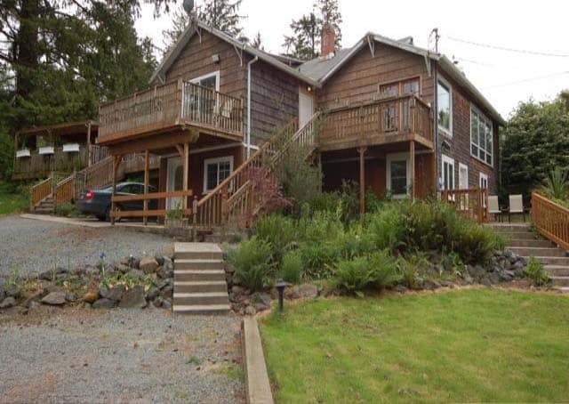
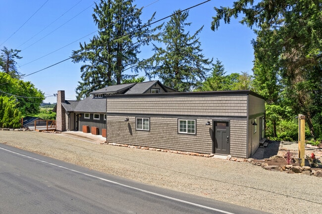
This Property Is For Sale
Property Detail
34910 Highway 53
R0292560
Tillamook
Commercialnec
Oregon
C-2
0.43 AC
AE The base floodplain where base flood elevations are provided. AE Zones are now used on new format FIRMs instead of A1-A30 Zones.
Oregon West Area
5,436 SF
Other Market Areas
NEARBY LISTINGS FOR SALE OR LEASE
-
-
View all Nehalem listings for sale on LoopNet.com
DEMOGRAPHICS near 34910 Highway 53
1 mile
3 mile
5 mile
2025 Total Population
131
2,148
4,649
2030 Population
129
2,153
4,801
Pop Growth 2025-2030
(1.53%)
+ 0.23%
+ 3.27%
Average Age
47
49
51
2025 Total Households
56
968
2,216
HH Growth 2025-2030
(1.79%)
(0.52%)
+ 2.98%
Median Household Inc
$55,000
$64,423
$74,079
Avg Household Size
2.10
2.20
2.00
2025 Avg HH Vehicles
2.00
2.00
2.00
Median Home Value
$462,499
$481,468
$612,894
Median Year Built
1977
1987
1988
Nearby Places
Map Layers
Map Styles
 Street
 Aerial
Transit
 Traffic
 Biking
Places
Listings with unknown addresses are not visible on the map
- Restaurants
- Banks
- Shops
- Fitness
- Groceries
Nearby Properties
Address
Land Use
TOTAL SIZE
Lot Size
Zoning
Address
Land Use
TOTAL SIZE
Lot Size
Zoning
14,786 SF
0.93 AC
R-3
Address
Land Use
TOTAL SIZE
Lot Size
Zoning
25,802 SF
2.61 AC
R1
Address
Land Use
TOTAL SIZE
Lot Size
Zoning
10 SF
44.34 AC
F-1
Address
Land Use
TOTAL SIZE
Lot Size
Zoning
27,802 SF
1.73 AC
R-2
Address
Land Use
TOTAL SIZE
Lot Size
Zoning
30,443 SF
1.72 AC
RM
Address
Land Use
TOTAL SIZE
Lot Size
Zoning
21,164 SF
1.38 AC
GC
Address
Land Use
TOTAL SIZE
Lot Size
Zoning
3,721 SF
2.99 AC
NH-R3
Address
Land Use
TOTAL SIZE
Lot Size
Zoning
10 SF
2.85 AC
RR
Address
Land Use
TOTAL SIZE
Lot Size
Zoning
32,596 SF
1.85 AC
C
Address
Land Use
TOTAL SIZE
Lot Size
Zoning
15,130 SF
1.23 AC
R1
Address
Land Use
TOTAL SIZE
Lot Size
Zoning
10,434 SF
0.44 AC
R-2
Address
Land Use
TOTAL SIZE
Lot Size
Zoning
21,658 SF
1.62 AC
NH-R3
Address
Land Use
TOTAL SIZE
Lot Size
Zoning
2,446 SF
0.11 AC
C-1
Address
Land Use
TOTAL SIZE
Lot Size
Zoning
10,328 SF
2.01 AC
RMD
Address
Land Use
TOTAL SIZE
Lot Size
Zoning
9,039 SF
0.23 AC
C-1
Address
Land Use
TOTAL SIZE
Lot Size
Zoning
6,304 SF
0.89 AC
WH-R-1
Address
Land Use
TOTAL SIZE
Lot Size
Zoning
10 SF
21.91 AC
R-2
Address
Land Use
TOTAL SIZE
Lot Size
Zoning
23,450 SF
1.37 AC
NH-C
Address
Land Use
TOTAL SIZE
Lot Size
Zoning
2,218 SF
6.99 AC
GC
Address
Land Use
TOTAL SIZE
Lot Size
Zoning
22,547 SF
1.59 AC
NH-R3
Address
Land Use
TOTAL SIZE
Lot Size
Zoning
6,607 SF
26.76 AC
F-1
Address
Land Use
TOTAL SIZE
Lot Size
Zoning
2,984 SF
3.37 AC
RR
Address
Land Use
TOTAL SIZE
Lot Size
Zoning
13,623 SF
44.81 AC
F-1
Address
Land Use
TOTAL SIZE
Lot Size
Zoning
9,834 SF
1 AC
CC
Address
Land Use
TOTAL SIZE
Lot Size
Zoning
128 SF
0.05 AC
NH-R1
Address
Land Use
TOTAL SIZE
Lot Size
Zoning
336 SF
17.02 AC
RR
Address
Land Use
TOTAL SIZE
Lot Size
Zoning
5,328 SF
0.56 AC
PUB
Address
Land Use
TOTAL SIZE
Lot Size
Zoning
3,829 SF
0.30 AC
NH-RL
Address
Land Use
TOTAL SIZE
Lot Size
Zoning
7,144 SF
0.77 AC
R-2
Address
Land Use
TOTAL SIZE
Lot Size
Zoning
8,687 SF
3.13 AC
F-1
The World's #1 Commercial Real Estate Marketplace
Connect with us
© 2026 CoStar Group
The information above has been obtained from sources believed reliable. While we do not doubt its accuracy we have not verified it and make no guarantee, warranty or representation about it. It is your responsibility to independently confirm its accuracy and completeness. Any projections, opinions, assumptions, or estimates used are for example only and do not represent the current or future performance of the property. The value of this transaction to you depends on tax and other factors which should be evaluated by your tax, financial, and legal advisors. You and your advisors should conduct a careful, independent investigation of the property to determine to your satisfaction the suitability of the property for your needs.