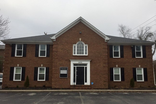
Property Record
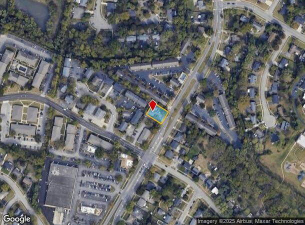
3493 Lansdowne Dr, Lexington, KY 40517
NEARBY LISTINGS FOR SALE OR LEASE
Property Detail
3493 Lansdowne Dr
Lexington-Fayette, KY
Stoneybrook
26678000
A-515 STONEYBROOK LOT 1 2; BOOK: 3370 PAGE: 611
Officebuilding
Fayette
X
Kentucky
2100670207F
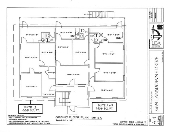
1-2
2025
0.33 AC
2025
East Lexington/Fayette
003501
Lexington/Fayette
5,000 SF
DEMOGRAPHICS near 3493 Lansdowne Dr
1 Mile
3 Mile
5 Mile
2024 Total Population
16,108
110,418
228,134
2029 Population
16,161
109,834
228,112
Pop Growth 2024-2029
+ 0.33%
(0.53%)
(0.01%)
Average Age
37
39
38
2024 Total Households
7,732
47,782
97,990
HH Growth 2024-2029
+ 0.26%
(0.59%)
(0.01%)
Median Household Inc
$49,783
$64,220
$58,649
Avg Household Size
2.10
2.20
2.20
2024 Avg HH Vehicles
2.00
2.00
2.00
Median Home Value
$193,237
$254,195
$263,439
Median Year Built
1976
1979
1980
Nearby Places
Map Layers
Map Styles
 Street
 Aerial
- Restaurants
- Banks
- Shops
- Fitness
- Groceries
PUBLIC TRANSPORTATION
AIRPORT
Blue Grass
DRIVE
WALK
Distance
Blue Grass
19 min
10.5 mi
SALE & LEASE HISTORY
LISTING DATE
SALE/LEASE

Jul 12, 2018
For Sale
Jul 12, 2018
For Lease
Jan 30, 2019
For Sale
Jan 26, 2018
For Lease
Feb 11, 2019
For Lease
Apr 27, 2020
For Lease
Nearby Properties
Address
Land Use
TOTAL SIZE
Lot Size
Zoning
Address
Land Use
TOTAL SIZE
Lot Size
Zoning
635,961 SF
23.52 AC
P-1
Address
Land Use
TOTAL SIZE
Lot Size
Zoning
510,633 SF
15.10 AC
P-1
Address
Land Use
TOTAL SIZE
Lot Size
Zoning
372,139 SF
4.82 AC
R-4
Address
Land Use
TOTAL SIZE
Lot Size
Zoning
582.34 AC
A-U
Address
Land Use
TOTAL SIZE
Lot Size
Zoning
76,441 SF
63.86 AC
A-U
Address
Land Use
TOTAL SIZE
Lot Size
Zoning
319,500 SF
0.25 AC
P-1
Address
Land Use
TOTAL SIZE
Lot Size
Zoning
318,370 SF
17.79 AC
B-6P
Address
Land Use
TOTAL SIZE
Lot Size
Zoning
292,730 SF
3.18 AC
R-1C
Address
Land Use
TOTAL SIZE
Lot Size
Zoning
4,299 SF
18.43 AC
R-4
Address
Land Use
TOTAL SIZE
Lot Size
Zoning
8,001 SF
32.59 AC
MU-3
Address
Land Use
TOTAL SIZE
Lot Size
Zoning
144,866 SF
14.83 AC
B-6P
Address
Land Use
TOTAL SIZE
Lot Size
Zoning
238,393 SF
9.83 AC
B-6P
Address
Land Use
TOTAL SIZE
Lot Size
Zoning
156,270 SF
11.18 AC
R-1C
Address
Land Use
TOTAL SIZE
Lot Size
Zoning
5,650 SF
22.46 AC
R-3
Address
Land Use
TOTAL SIZE
Lot Size
Zoning
22.10 AC
R-3
Address
Land Use
TOTAL SIZE
Lot Size
Zoning
12,767 SF
14.39 AC
R-3
Address
Land Use
TOTAL SIZE
Lot Size
Zoning
41,040 SF
14.77 AC
R-4
Address
Land Use
TOTAL SIZE
Lot Size
Zoning
184,756 SF
4.43 AC
MU-3
Address
Land Use
TOTAL SIZE
Lot Size
Zoning
91,484 SF
14.72 AC
B-6P
Address
Land Use
TOTAL SIZE
Lot Size
Zoning
7,402 SF
18.83 AC
R-4
Address
Land Use
TOTAL SIZE
Lot Size
Zoning
137,905 SF
23.79 AC
B-6P
Address
Land Use
TOTAL SIZE
Lot Size
Zoning
59,586 SF
5.37 AC
R-4
Address
Land Use
TOTAL SIZE
Lot Size
Zoning
4,859 SF
20.45 AC
R-3
Address
Land Use
TOTAL SIZE
Lot Size
Zoning
6.25 AC
A-U
Address
Land Use
TOTAL SIZE
Lot Size
Zoning
23,042 SF
8.90 AC
R-4
Address
Land Use
TOTAL SIZE
Lot Size
Zoning
123,221 SF
17.32 AC
R-1B
Address
Land Use
TOTAL SIZE
Lot Size
Zoning
28,776 SF
13.83 AC
B-1
Address
Land Use
TOTAL SIZE
Lot Size
Zoning
73,590 SF
13.31 AC
R-1T
Address
Land Use
TOTAL SIZE
Lot Size
Zoning
25,880 SF
0.78 AC
P-1
Address
Land Use
TOTAL SIZE
Lot Size
Zoning
222,168 SF
26.49 AC
B-6P
The World's #1 Commercial Real Estate Marketplace
Connect with us
© 2025 CoStar Group
The information above has been obtained from sources believed reliable. While we do not doubt its accuracy we have not verified it and make no guarantee, warranty or representation about it. It is your responsibility to independently confirm its accuracy and completeness. Any projections, opinions, assumptions, or estimates used are for example only and do not represent the current or future performance of the property. The value of this transaction to you depends on tax and other factors which should be evaluated by your tax, financial, and legal advisors. You and your advisors should conduct a careful, independent investigation of the property to determine to your satisfaction the suitability of the property for your needs.