Property Record
35 82Nd Dr, Gladstone, OR 97027
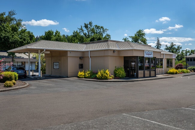

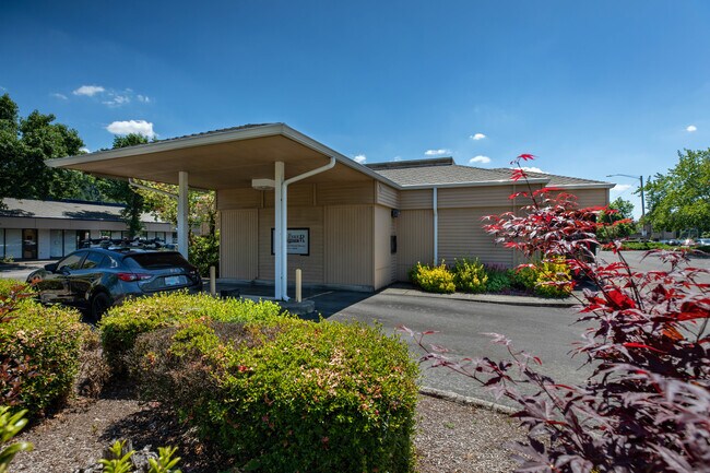
Property Detail
35 82Nd Dr
Portland-Vancouver-Hillsboro, OR-WA
SECTION 20 TOWNSHIP 2S RANGE 2E TAX LOT 00401
00529798
Clackamas
Commercialbuilding
Oregon
C3
401
AE The base floodplain where base flood elevations are provided. AE Zones are now used on new format FIRMs instead of A1-A30 Zones.
0.85 AC
2025
Clackamas/Milwaukie
2025
Portland
022000
NEARBY LISTINGS FOR SALE OR LEASE
DEMOGRAPHICS near 35 82Nd Dr
1 mile
3 mile
5 mile
2024 Total Population
9,556
68,325
197,899
2029 Population
9,783
69,783
202,211
Pop Growth 2024-2029
+ 2.38%
+ 2.13%
+ 2.18%
Average Age
42
43
42
2024 Total Households
3,660
26,512
76,400
HH Growth 2024-2029
+ 2.38%
+ 2.12%
+ 2.18%
Median Household Inc
$89,683
$88,376
$90,975
Avg Household Size
2.50
2.50
2.50
2024 Avg HH Vehicles
2.00
2.00
2.00
Median Home Value
$444,991
$474,102
$494,364
Median Year Built
1974
1976
1982
Nearby Places
Map Layers
Map Styles
 Street
 Aerial
Transit
 Traffic
 Biking
Places
Listings with unknown addresses are not visible on the map
- Restaurants
- Banks
- Shops
- Fitness
- Groceries
PUBLIC TRANSPORTATION
COMMUTER RAIL
Drive
Walk
Distance
6 min
2.4 mi
AIRPORT
Portland International
Drive
Walk
Distance
Portland International
27 min
16.9 mi
Freight Ports
Port of Portland
Drive
Walk
Distance
Port of Portland
30 min
15.8 mi
SALE & LEASE HISTORY
LISTING DATE
SALE/LEASE

Sep 25, 2016
For Lease
Jul 12, 2022
For Lease
Nearby Properties
Address
Land Use
TOTAL SIZE
Lot Size
Zoning
Address
Land Use
TOTAL SIZE
Lot Size
Zoning
15.26 AC
GI
Address
Land Use
TOTAL SIZE
Lot Size
Zoning
40.94 AC
IPU
Address
Land Use
TOTAL SIZE
Lot Size
Zoning
9,233 SF
8.27 AC
MUE
Address
Land Use
TOTAL SIZE
Lot Size
Zoning
4,654 SF
73.99 AC
LI
Address
Land Use
TOTAL SIZE
Lot Size
Zoning
45 AC
GI
Address
Land Use
TOTAL SIZE
Lot Size
Zoning
12.16 AC
C3
Address
Land Use
TOTAL SIZE
Lot Size
Zoning
14.06 AC
C3
Address
Land Use
TOTAL SIZE
Lot Size
Zoning
6 AC
GI
Address
Land Use
TOTAL SIZE
Lot Size
Zoning
12 AC
LI
Address
Land Use
TOTAL SIZE
Lot Size
Zoning
7.25 AC
LI
Address
Land Use
TOTAL SIZE
Lot Size
Zoning
17.04 AC
GI
Address
Land Use
TOTAL SIZE
Lot Size
Zoning
2,510 SF
16.02 AC
GI
Address
Land Use
TOTAL SIZE
Lot Size
Zoning
3.11 AC
GC
Address
Land Use
TOTAL SIZE
Lot Size
Zoning
2,482 SF
5.14 AC
MR
Address
Land Use
TOTAL SIZE
Lot Size
Zoning
11 AC
MUD
Address
Land Use
TOTAL SIZE
Lot Size
Zoning
16.49 AC
MUD
Address
Land Use
TOTAL SIZE
Lot Size
Zoning
Address
Land Use
TOTAL SIZE
Lot Size
Zoning
70.97 AC
OP
Address
Land Use
TOTAL SIZE
Lot Size
Zoning
Address
Land Use
TOTAL SIZE
Lot Size
Zoning
3.18 AC
C3
Address
Land Use
TOTAL SIZE
Lot Size
Zoning
1,386 SF
12.64 AC
GI
Address
Land Use
TOTAL SIZE
Lot Size
Zoning
8.27 AC
MR
Address
Land Use
TOTAL SIZE
Lot Size
Zoning
6 AC
OP
Address
Land Use
TOTAL SIZE
Lot Size
Zoning
4 AC
GI
Address
Land Use
TOTAL SIZE
Lot Size
Zoning
2,031 SF
3.91 AC
R10
Address
Land Use
TOTAL SIZE
Lot Size
Zoning
9.90 AC
LI
Address
Land Use
TOTAL SIZE
Lot Size
Zoning
Address
Land Use
TOTAL SIZE
Lot Size
Zoning
8 AC
GI
Address
Land Use
TOTAL SIZE
Lot Size
Zoning
9.67 AC
C3
The World's #1 Commercial Real Estate Marketplace
Connect with us
© 2026 CoStar Group
The information above has been obtained from sources believed reliable. While we do not doubt its accuracy we have not verified it and make no guarantee, warranty or representation about it. It is your responsibility to independently confirm its accuracy and completeness. Any projections, opinions, assumptions, or estimates used are for example only and do not represent the current or future performance of the property. The value of this transaction to you depends on tax and other factors which should be evaluated by your tax, financial, and legal advisors. You and your advisors should conduct a careful, independent investigation of the property to determine to your satisfaction the suitability of the property for your needs.