Property Record
35 Broad St, Manasquan, NJ 08736


Save to a Folder
{{folder.Name}}
{{folder.ListingIds.length}} Properties
{{folder.ListingIds.length}} Property
Create a New Folder
Property Detail
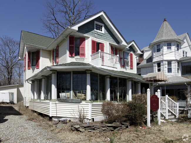
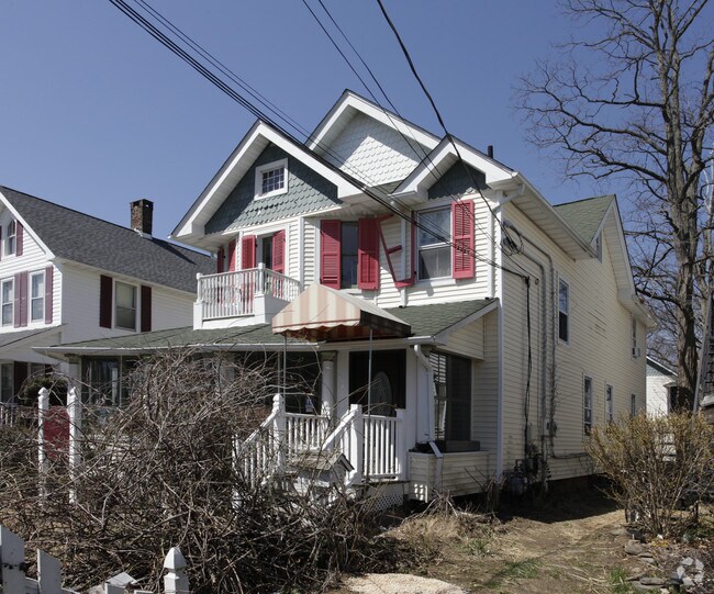
35 Broad St
29-00035-0000-00021
Monmouth
Storemultistory
New Jersey
R-2
21
B and X Area of moderate flood hazard, usually the area between the limits of the 100-year and 500-year floods.
0.13 AC
2025
Southern Monmouth
2026
Northern New Jersey
809301
Lakewood-New Brunswick, NJ
2,114 SF
NEARBY LISTINGS FOR SALE OR LEASE
DEMOGRAPHICS near 35 Broad St
1 mile
3 mile
5 mile
2025 Total Population
11,464
49,170
124,342
2030 Population
11,681
50,791
127,560
Pop Growth 2025-2030
+ 1.89%
+ 3.30%
+ 2.59%
Average Age
45
46
44
2025 Total Households
4,486
20,603
50,724
HH Growth 2025-2030
+ 1.83%
+ 3.33%
+ 2.47%
Median Household Inc
$170,390
$128,296
$117,845
Avg Household Size
2.50
2.30
2.40
2025 Avg HH Vehicles
2.00
2.00
2.00
Median Home Value
$912,732
$842,438
$667,806
Median Year Built
1961
1968
1970
Nearby Places
Map Layers
Map Styles
 Street
 Aerial
Layers
 Traffic
 Biking
Places
Listings with unknown addresses are not visible on the map
- Restaurants
- Banks
- Shops
- Fitness
- Groceries
PUBLIC TRANSPORTATION
TRANSIT/SUBWAY
Manasquan (North Jersey Coast Line - NJ Transit Commuter Rail (NJ Transit))
Drive
Walk
Distance
Manasquan (North Jersey Coast Line - NJ Transit Commuter Rail (NJ Transit))
1 min
8 min
0.4 mi
COMMUTER RAIL
Manasquan (North Jersey Coast Line - NJ Transit Commuter Rail (NJ Transit))
Drive
Walk
Distance
Manasquan (North Jersey Coast Line - NJ Transit Commuter Rail (NJ Transit))
1 min
8 min
0.4 mi
Spring Lake (North Jersey Coast Line - NJ Transit Commuter Rail (NJ Transit))
Drive
Walk
Distance
Spring Lake (North Jersey Coast Line - NJ Transit Commuter Rail (NJ Transit))
5 min
2.3 mi
Freight Ports
New York Container Terminal
Drive
Walk
Distance
New York Container Terminal
64 min
48.0 mi
Nearby Properties
Address
Land Use
TOTAL SIZE
Lot Size
Zoning
Address
Land Use
TOTAL SIZE
Lot Size
Zoning
22,660 SF
164.35 AC
4
Address
Land Use
TOTAL SIZE
Lot Size
Zoning
2,596 SF
54.13 AC
SF10
Address
Land Use
TOTAL SIZE
Lot Size
Zoning
1,846 SF
23.23 AC
SF10
Address
Land Use
TOTAL SIZE
Lot Size
Zoning
23,868 SF
137.35 AC
SF40
Address
Land Use
TOTAL SIZE
Lot Size
Zoning
4,078 SF
11.84 AC
SF05
Address
Land Use
TOTAL SIZE
Lot Size
Zoning
3.46 AC
SF05
Address
Land Use
TOTAL SIZE
Lot Size
Zoning
21 AC
ROS
Address
Land Use
TOTAL SIZE
Lot Size
Zoning
5,000 SF
22.50 AC
CONREC
Address
Land Use
TOTAL SIZE
Lot Size
Zoning
35,639 SF
99.30 AC
SF20
Address
Land Use
TOTAL SIZE
Lot Size
Zoning
17.66 AC
1E
Address
Land Use
TOTAL SIZE
Lot Size
Zoning
20,959 SF
3.10 AC
SF10
Address
Land Use
TOTAL SIZE
Lot Size
Zoning
71,070 SF
11.81 AC
MLHB
Address
Land Use
TOTAL SIZE
Lot Size
Zoning
49,657 SF
11.22 AC
HB80
Address
Land Use
TOTAL SIZE
Lot Size
Zoning
61,432 SF
3.44 AC
SF05
Address
Land Use
TOTAL SIZE
Lot Size
Zoning
7.79 AC
MLCC
Address
Land Use
TOTAL SIZE
Lot Size
Zoning
9.30 AC
SF05
Address
Land Use
TOTAL SIZE
Lot Size
Zoning
61,536 SF
3.44 AC
SF05
Address
Land Use
TOTAL SIZE
Lot Size
Zoning
84,297 SF
42.37 AC
CR40
Address
Land Use
TOTAL SIZE
Lot Size
Zoning
49,170 SF
8.38 AC
HB80
Address
Land Use
TOTAL SIZE
Lot Size
Zoning
43,217 SF
0.86 AC
SF10
Address
Land Use
TOTAL SIZE
Lot Size
Zoning
45,236 SF
48.30 AC
POS
Address
Land Use
TOTAL SIZE
Lot Size
Zoning
320 SF
1.55 AC
1E
Address
Land Use
TOTAL SIZE
Lot Size
Zoning
26.05 AC
SF10
Address
Land Use
TOTAL SIZE
Lot Size
Zoning
6.43 AC
SF05
Address
Land Use
TOTAL SIZE
Lot Size
Zoning
3,792 SF
7.64 AC
R-1A
Address
Land Use
TOTAL SIZE
Lot Size
Zoning
48,984 SF
5.53 AC
R-5
Address
Land Use
TOTAL SIZE
Lot Size
Zoning
8.83 AC
R-2
Address
Land Use
TOTAL SIZE
Lot Size
Zoning
2.10 AC
ROS
Address
Land Use
TOTAL SIZE
Lot Size
Zoning
115,960 SF
17.93 AC
OR-5
Address
Land Use
TOTAL SIZE
Lot Size
Zoning
111,580 SF
25 AC
POS
The World's #1 Commercial Real Estate Marketplace
Connect with us
© 2026 CoStar Group
The information above has been obtained from sources believed reliable. While we do not doubt its accuracy we have not verified it and make no guarantee, warranty or representation about it. It is your responsibility to independently confirm its accuracy and completeness. Any projections, opinions, assumptions, or estimates used are for example only and do not represent the current or future performance of the property. The value of this transaction to you depends on tax and other factors which should be evaluated by your tax, financial, and legal advisors. You and your advisors should conduct a careful, independent investigation of the property to determine to your satisfaction the suitability of the property for your needs.