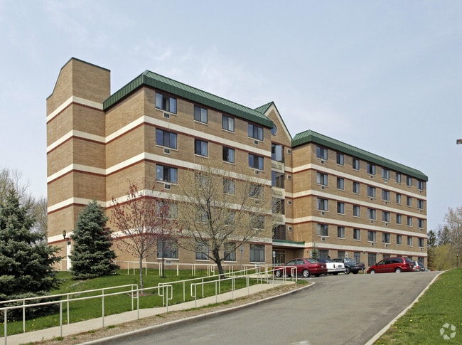
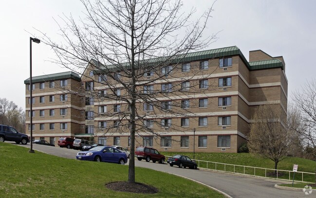
Property Record
35 Cerone Pl, Newburgh, NY 12550

Property Detail
35 Cerone Pl
331100-033-000-0002-016.100-0000
LT 1 SENIOR SHELTERS INC SUB MAP 55-96 COURT ORDER
Apartment
Orange
RH
New York
B and X Area of moderate flood hazard, usually the area between the limits of the 100-year and 500-year floods.
16.10
2024
2.70 AC
2024
Newburgh
000600
Northern New Jersey
51,641 SF
Kiryas Joel-Poughkeepsie-Newburgh, NY
NEARBY LISTINGS FOR SALE OR LEASE
DEMOGRAPHICS near 35 Cerone Pl
1 mile
3 mile
5 mile
2025 Total Population
14,414
57,544
108,537
2030 Population
14,368
58,478
110,392
Pop Growth 2025-2030
(0.32%)
+ 1.62%
+ 1.71%
Average Age
36
39
40
2025 Total Households
4,846
21,348
40,430
HH Growth 2025-2030
(0.27%)
+ 1.73%
+ 1.77%
Median Household Inc
$63,479
$76,562
$88,508
Avg Household Size
2.90
2.60
2.50
2025 Avg HH Vehicles
1.00
2.00
2.00
Median Home Value
$238,695
$327,084
$375,303
Median Year Built
1947
1959
1965
Nearby Places
Map Layers
Map Styles
 Street
 Aerial
Transit
 Traffic
 Biking
Places
Listings with unknown addresses are not visible on the map
- Restaurants
- Banks
- Shops
- Fitness
- Groceries
PUBLIC TRANSPORTATION
COMMUTER RAIL
Beacon Station (Hudson Line - Metro-North Commuter Railroad Company (Metro-North))
Drive
Walk
Distance
Beacon Station (Hudson Line - Metro-North Commuter Railroad Company (Metro-North))
12 min
5.8 mi
Salisbury Mills Cornwall (Bergen County/Port Jervis Line - NJ Transit Commuter Rail (NJ Transit), Main/Port Jervis Line - NJ Transit Commuter Rail (NJ Transit))
Drive
Walk
Distance
Salisbury Mills Cornwall (Bergen County/Port Jervis Line - NJ Transit Commuter Rail (NJ Transit), Main/Port Jervis Line - NJ Transit Commuter Rail (NJ Transit))
14 min
6.6 mi
AIRPORT
New York Stewart International
Drive
Walk
Distance
New York Stewart International
12 min
5.5 mi
Nearby Properties
Address
Land Use
TOTAL SIZE
Lot Size
Zoning
Address
Land Use
TOTAL SIZE
Lot Size
Zoning
211,240 SF
5.30 AC
WG
Address
Land Use
TOTAL SIZE
Lot Size
Zoning
325,026 SF
6.30 AC
RM
Address
Land Use
TOTAL SIZE
Lot Size
Zoning
355,349 SF
28.50 AC
RM
Address
Land Use
TOTAL SIZE
Lot Size
Zoning
345,572 SF
43.80 AC
R-1
Address
Land Use
TOTAL SIZE
Lot Size
Zoning
88,103 SF
32.60 AC
RH
Address
Land Use
TOTAL SIZE
Lot Size
Zoning
927,041 SF
104.37 AC
Address
Land Use
TOTAL SIZE
Lot Size
Zoning
272,943 SF
17 AC
RL
Address
Land Use
TOTAL SIZE
Lot Size
Zoning
110,384 SF
13.10 AC
RM
Address
Land Use
TOTAL SIZE
Lot Size
Zoning
112,136 SF
2.70 AC
RM
Address
Land Use
TOTAL SIZE
Lot Size
Zoning
45.48 AC
HI
Address
Land Use
TOTAL SIZE
Lot Size
Zoning
10,746 SF
11 AC
PWD
Address
Land Use
TOTAL SIZE
Lot Size
Zoning
182,318 SF
9.20 AC
RL
Address
Land Use
TOTAL SIZE
Lot Size
Zoning
200 SF
11.97 AC
RD-3
Address
Land Use
TOTAL SIZE
Lot Size
Zoning
20.50 AC
Address
Land Use
TOTAL SIZE
Lot Size
Zoning
91,705 SF
1.90 AC
RM
Address
Land Use
TOTAL SIZE
Lot Size
Zoning
5.70 AC
RD-3
Address
Land Use
TOTAL SIZE
Lot Size
Zoning
1.20 AC
Address
Land Use
TOTAL SIZE
Lot Size
Zoning
176,680 SF
1.28 AC
RM
Address
Land Use
TOTAL SIZE
Lot Size
Zoning
82,344 SF
1.80 AC
RH
Address
Land Use
TOTAL SIZE
Lot Size
Zoning
59,220 SF
6.40 AC
CD
Address
Land Use
TOTAL SIZE
Lot Size
Zoning
16.32 AC
RD-3
Address
Land Use
TOTAL SIZE
Lot Size
Zoning
660.70 AC
AP
Address
Land Use
TOTAL SIZE
Lot Size
Zoning
69,006 SF
1.77 AC
DN
Address
Land Use
TOTAL SIZE
Lot Size
Zoning
213,521 SF
8 AC
RH
Address
Land Use
TOTAL SIZE
Lot Size
Zoning
739.80 AC
Address
Land Use
TOTAL SIZE
Lot Size
Zoning
94,608 SF
3.90 AC
RH
Address
Land Use
TOTAL SIZE
Lot Size
Zoning
71.72 AC
Address
Land Use
TOTAL SIZE
Lot Size
Zoning
107,016 SF
0.79 AC
WG
Address
Land Use
TOTAL SIZE
Lot Size
Zoning
505,577 SF
50.50 AC
Address
Land Use
TOTAL SIZE
Lot Size
Zoning
265,660 SF
24.20 AC
The World's #1 Commercial Real Estate Marketplace
Connect with us
© 2026 CoStar Group
The information above has been obtained from sources believed reliable. While we do not doubt its accuracy we have not verified it and make no guarantee, warranty or representation about it. It is your responsibility to independently confirm its accuracy and completeness. Any projections, opinions, assumptions, or estimates used are for example only and do not represent the current or future performance of the property. The value of this transaction to you depends on tax and other factors which should be evaluated by your tax, financial, and legal advisors. You and your advisors should conduct a careful, independent investigation of the property to determine to your satisfaction the suitability of the property for your needs.