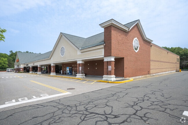
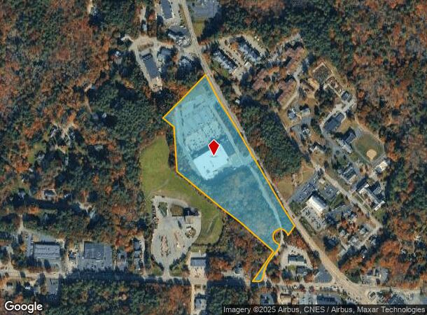
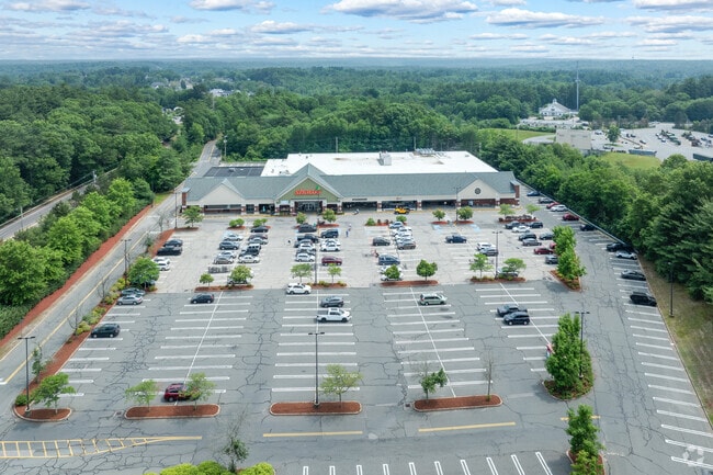
Property Record
35 Columbia Rd, Hanover, MA 02339
Current Lease Availabilities
NEARBY LISTINGS FOR SALE OR LEASE
Property Detail
35 Columbia Rd
HANO-000048-000000-000025
Plymouth
Supermarket
Massachusetts
A
25
25023C0202K
15.10 AC
2025
Route 3 Corridor
2025
Boston
503102
Boston-Cambridge-Newton, MA-NH
60,274 SF
DEMOGRAPHICS near 35 Columbia Rd
1 mile
3 mile
5 mile
2024 Total Population
3,005
19,183
64,153
2029 Population
3,022
19,257
64,243
Pop Growth 2024-2029
+ 0.57%
+ 0.39%
+ 0.14%
Average Age
43
41
42
2024 Total Households
1,150
6,641
22,953
HH Growth 2024-2029
+ 0.52%
+ 0.35%
+ 0.10%
Median Household Inc
$141,017
$162,167
$134,837
Avg Household Size
2.50
2.80
2.70
2024 Avg HH Vehicles
2.00
2.00
2.00
Median Home Value
$670,270
$680,990
$580,196
Median Year Built
1979
1974
1973
Nearby Places
Map Layers
Map Styles
 Street
 Aerial
Transit
 Traffic
 Biking
Places
Listings with unknown addresses are not visible on the map
- Restaurants
- Banks
- Shops
- Fitness
- Groceries
PUBLIC TRANSPORTATION
COMMUTER RAIL
Abington (Kingston/Plymouth Line - Massachusetts Bay Transportation Authority Commuter Rail (Purple Line))
Drive
Walk
Distance
Abington (Kingston/Plymouth Line - Massachusetts Bay Transportation Authority Commuter Rail (Purple Line))
14 min
7.0 mi
Greenbush (Greenbush Line - Massachusetts Bay Transportation Authority Commuter Rail (Purple Line))
Drive
Walk
Distance
Greenbush (Greenbush Line - Massachusetts Bay Transportation Authority Commuter Rail (Purple Line))
14 min
7.3 mi
AIRPORT
General Edward Lawrence Logan International
Drive
Walk
Distance
General Edward Lawrence Logan International
40 min
26.8 mi
Nearby Properties
Address
Land Use
TOTAL SIZE
Lot Size
Zoning
Address
Land Use
TOTAL SIZE
Lot Size
Zoning
67.07 AC
Address
Land Use
TOTAL SIZE
Lot Size
Zoning
23.41 AC
R
Address
Land Use
TOTAL SIZE
Lot Size
Zoning
13.15 AC
Address
Land Use
TOTAL SIZE
Lot Size
Zoning
236,855 SF
33.47 AC
Address
Land Use
TOTAL SIZE
Lot Size
Zoning
78.50 AC
R
Address
Land Use
TOTAL SIZE
Lot Size
Zoning
94.53 AC
Address
Land Use
TOTAL SIZE
Lot Size
Zoning
141,514 SF
46.60 AC
R
Address
Land Use
TOTAL SIZE
Lot Size
Zoning
91,586 SF
13.70 AC
R
Address
Land Use
TOTAL SIZE
Lot Size
Zoning
121,800 SF
0.97 AC
C
Address
Land Use
TOTAL SIZE
Lot Size
Zoning
110,942 SF
2.11 AC
Address
Land Use
TOTAL SIZE
Lot Size
Zoning
108,958 SF
7.37 AC
LI
Address
Land Use
TOTAL SIZE
Lot Size
Zoning
93,933 SF
13 AC
Address
Land Use
TOTAL SIZE
Lot Size
Zoning
13.10 AC
Address
Land Use
TOTAL SIZE
Lot Size
Zoning
137,617 SF
24.54 AC
C
Address
Land Use
TOTAL SIZE
Lot Size
Zoning
12.04 AC
C
Address
Land Use
TOTAL SIZE
Lot Size
Zoning
25,262 SF
244 AC
Address
Land Use
TOTAL SIZE
Lot Size
Zoning
136,577 SF
17.63 AC
Address
Land Use
TOTAL SIZE
Lot Size
Zoning
29,662 SF
3.98 AC
Address
Land Use
TOTAL SIZE
Lot Size
Zoning
24.07 AC
BD
Address
Land Use
TOTAL SIZE
Lot Size
Zoning
3.88 AC
BD
Address
Land Use
TOTAL SIZE
Lot Size
Zoning
48,300 SF
7.81 AC
PSC
Address
Land Use
TOTAL SIZE
Lot Size
Zoning
44,189 SF
10.87 AC
Address
Land Use
TOTAL SIZE
Lot Size
Zoning
11.48 AC
C
Address
Land Use
TOTAL SIZE
Lot Size
Zoning
47,909 SF
12.59 AC
C
Address
Land Use
TOTAL SIZE
Lot Size
Zoning
14.20 AC
C
Address
Land Use
TOTAL SIZE
Lot Size
Zoning
23.31 AC
B
Address
Land Use
TOTAL SIZE
Lot Size
Zoning
184,542 SF
13.58 AC
I
Address
Land Use
TOTAL SIZE
Lot Size
Zoning
2.25 AC
Address
Land Use
TOTAL SIZE
Lot Size
Zoning
756 SF
11.11 AC
The World's #1 Commercial Real Estate Marketplace
Connect with us
© 2026 CoStar Group
The information above has been obtained from sources believed reliable. While we do not doubt its accuracy we have not verified it and make no guarantee, warranty or representation about it. It is your responsibility to independently confirm its accuracy and completeness. Any projections, opinions, assumptions, or estimates used are for example only and do not represent the current or future performance of the property. The value of this transaction to you depends on tax and other factors which should be evaluated by your tax, financial, and legal advisors. You and your advisors should conduct a careful, independent investigation of the property to determine to your satisfaction the suitability of the property for your needs.