Property Record
35 Cr, Auburn, IN 46706

NEARBY LISTINGS FOR SALE OR LEASE
-
-
View all Auburn listings for sale on LoopNet.com
Property Detail
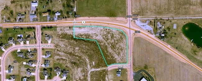
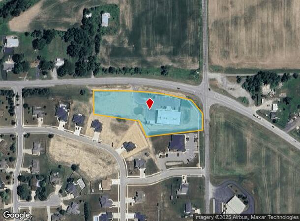
35 Cr
Auburn, IN
Hunters Glen Sec Iii
17-06-33-200-079.000-025
AMENDED LOT #1 HUNTERS GLEN SEC III LOT 1B LOT # 1B ACRES 2.869
Commercialacreage
Dekalb
X
Indiana
18033C0232E
1,1b
2024
2.87 AC
2024
Fort Wayne
020400
Other Market Areas
DEMOGRAPHICS near 35 Cr
1 mile
3 mile
5 mile
2024 Total Population
3,909
16,721
22,097
2029 Population
4,038
17,242
22,756
Pop Growth 2024-2029
+ 3.30%
+ 3.12%
+ 2.98%
Average Age
43
41
41
2024 Total Households
1,694
6,900
8,871
HH Growth 2024-2029
+ 3.31%
+ 3.14%
+ 2.99%
Median Household Inc
$68,757
$60,186
$62,850
Avg Household Size
2.20
2.30
2.40
2024 Avg HH Vehicles
2.00
2.00
2.00
Median Home Value
$181,870
$159,007
$163,581
Median Year Built
1990
1982
1982
Nearby Places
Map Layers
Map Styles
 Street
 Aerial
Transit
 Traffic
 Biking
Places
Listings with unknown addresses are not visible on the map
- Restaurants
- Banks
- Shops
- Fitness
- Groceries
PUBLIC TRANSPORTATION
COMMUTER RAIL
Drive
Walk
Distance
11 min
4.5 mi
AIRPORT
Fort Wayne International
Drive
Walk
Distance
Fort Wayne International
50 min
38.0 mi
SALE & LEASE HISTORY
LISTING DATE
SALE/LEASE

Feb 21, 2017
For Sale
Nearby Properties
Address
Land Use
TOTAL SIZE
Lot Size
Zoning
Address
Land Use
TOTAL SIZE
Lot Size
Zoning
77,765 SF
24.02 AC
Address
Land Use
TOTAL SIZE
Lot Size
Zoning
59,049 SF
12.73 AC
Address
Land Use
TOTAL SIZE
Lot Size
Zoning
180,835 SF
18.82 AC
Address
Land Use
TOTAL SIZE
Lot Size
Zoning
20,078 SF
3.63 AC
Address
Land Use
TOTAL SIZE
Lot Size
Zoning
13,200 SF
49.95 AC
Address
Land Use
TOTAL SIZE
Lot Size
Zoning
26,488 SF
12.12 AC
Address
Land Use
TOTAL SIZE
Lot Size
Zoning
400 SF
7.70 AC
Address
Land Use
TOTAL SIZE
Lot Size
Zoning
6,000 SF
42.17 AC
Address
Land Use
TOTAL SIZE
Lot Size
Zoning
37,152 SF
7.81 AC
Address
Land Use
TOTAL SIZE
Lot Size
Zoning
130,185 SF
34.82 AC
Address
Land Use
TOTAL SIZE
Lot Size
Zoning
28,390 SF
0.09 AC
Address
Land Use
TOTAL SIZE
Lot Size
Zoning
45,874 SF
3.94 AC
Address
Land Use
TOTAL SIZE
Lot Size
Zoning
87,840 SF
7.12 AC
Address
Land Use
TOTAL SIZE
Lot Size
Zoning
14,760 SF
6.54 AC
Address
Land Use
TOTAL SIZE
Lot Size
Zoning
14,294 SF
80 AC
Address
Land Use
TOTAL SIZE
Lot Size
Zoning
5,184 SF
113.45 AC
Address
Land Use
TOTAL SIZE
Lot Size
Zoning
103,888 SF
30 AC
Address
Land Use
TOTAL SIZE
Lot Size
Zoning
4,048 SF
14.92 AC
Address
Land Use
TOTAL SIZE
Lot Size
Zoning
1,876 SF
71.05 AC
Address
Land Use
TOTAL SIZE
Lot Size
Zoning
75,878 SF
1.05 AC
Address
Land Use
TOTAL SIZE
Lot Size
Zoning
22,000 SF
7.90 AC
Address
Land Use
TOTAL SIZE
Lot Size
Zoning
19,936 SF
10.47 AC
Address
Land Use
TOTAL SIZE
Lot Size
Zoning
57,886 SF
19.56 AC
Address
Land Use
TOTAL SIZE
Lot Size
Zoning
62,856 SF
1.80 AC
Address
Land Use
TOTAL SIZE
Lot Size
Zoning
48,000 SF
5.29 AC
Address
Land Use
TOTAL SIZE
Lot Size
Zoning
14,440 SF
0.21 AC
Address
Land Use
TOTAL SIZE
Lot Size
Zoning
22,456 SF
27.90 AC
Address
Land Use
TOTAL SIZE
Lot Size
Zoning
10,200 SF
13.13 AC
Address
Land Use
TOTAL SIZE
Lot Size
Zoning
146,310 SF
11.80 AC
Address
Land Use
TOTAL SIZE
Lot Size
Zoning
10,552 SF
33.96 AC
The World's #1 Commercial Real Estate Marketplace
Connect with us
© 2026 CoStar Group
The information above has been obtained from sources believed reliable. While we do not doubt its accuracy we have not verified it and make no guarantee, warranty or representation about it. It is your responsibility to independently confirm its accuracy and completeness. Any projections, opinions, assumptions, or estimates used are for example only and do not represent the current or future performance of the property. The value of this transaction to you depends on tax and other factors which should be evaluated by your tax, financial, and legal advisors. You and your advisors should conduct a careful, independent investigation of the property to determine to your satisfaction the suitability of the property for your needs.