Property Record
35 Easy St, Buellton, CA 93427
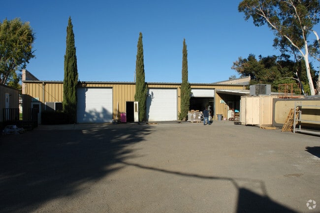

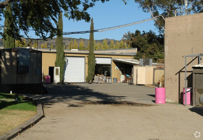
Property Detail
35 Easy St
137-500-018
SANTA BARBARA
Lightindustrial
California
B and X Area of moderate flood hazard, usually the area between the limits of the 100-year and 500-year floods.
c
2024
0.43 AC
2025
Central SB County
001912
Santa Barbara/Sta Maria/Goleta
10,536 SF
Santa Maria-Santa Barbara, CA
NEARBY LISTINGS FOR SALE OR LEASE
-
-
View all Buellton listings for lease on LoopNet.com
DEMOGRAPHICS near 35 Easy St
1 mile
3 mile
5 mile
2025 Total Population
2,739
5,846
13,254
2030 Population
2,579
5,609
12,785
Pop Growth 2025-2030
(5.84%)
(4.05%)
(3.54%)
Average Age
40
42
44
2025 Total Households
1,019
2,200
5,142
HH Growth 2025-2030
(5.99%)
(4.18%)
(3.68%)
Median Household Inc
$97,861
$100,661
$113,334
Avg Household Size
2.70
2.60
2.50
2025 Avg HH Vehicles
2.00
2.00
2.00
Median Home Value
$777,597
$802,145
$960,875
Median Year Built
1993
1990
1983
Nearby Places
Map Layers
Map Styles
 Street
 Aerial
Layers
 Traffic
 Biking
Places
Listings with unknown addresses are not visible on the map
- Restaurants
- Banks
- Shops
- Fitness
- Groceries
PUBLIC TRANSPORTATION
AIRPORT
Santa Barbara Municipal
Drive
Walk
Distance
Santa Barbara Municipal
47 min
36.8 mi
SALE & LEASE HISTORY
LISTING DATE
SALE/LEASE

Mar 29, 2017
For Lease
Nearby Properties
Address
Land Use
TOTAL SIZE
Lot Size
Zoning
Address
Land Use
TOTAL SIZE
Lot Size
Zoning
2.11 AC
Address
Land Use
TOTAL SIZE
Lot Size
Zoning
4.21 AC
Address
Land Use
TOTAL SIZE
Lot Size
Zoning
3.63 AC
Address
Land Use
TOTAL SIZE
Lot Size
Zoning
3.19 AC
AGI40
Address
Land Use
TOTAL SIZE
Lot Size
Zoning
3.06 AC
Address
Land Use
TOTAL SIZE
Lot Size
Zoning
3,086 SF
68.19 AC
AGII40
Address
Land Use
TOTAL SIZE
Lot Size
Zoning
50,439 SF
3.30 AC
Address
Land Use
TOTAL SIZE
Lot Size
Zoning
Address
Land Use
TOTAL SIZE
Lot Size
Zoning
137,419 SF
5.12 AC
Address
Land Use
TOTAL SIZE
Lot Size
Zoning
2,110 SF
3.01 AC
Address
Land Use
TOTAL SIZE
Lot Size
Zoning
2.07 AC
Address
Land Use
TOTAL SIZE
Lot Size
Zoning
2.35 AC
Address
Land Use
TOTAL SIZE
Lot Size
Zoning
1.57 AC
Address
Land Use
TOTAL SIZE
Lot Size
Zoning
2.11 AC
Address
Land Use
TOTAL SIZE
Lot Size
Zoning
8.99 AC
Address
Land Use
TOTAL SIZE
Lot Size
Zoning
445.97 AC
AGII100
Address
Land Use
TOTAL SIZE
Lot Size
Zoning
3,282 SF
62.61 AC
AGII40
Address
Land Use
TOTAL SIZE
Lot Size
Zoning
35.61 AC
AGI40
Address
Land Use
TOTAL SIZE
Lot Size
Zoning
208.02 AC
AGII100
Address
Land Use
TOTAL SIZE
Lot Size
Zoning
2.45 AC
Address
Land Use
TOTAL SIZE
Lot Size
Zoning
14,227 SF
2.32 AC
Address
Land Use
TOTAL SIZE
Lot Size
Zoning
219.26 AC
AGII100
Address
Land Use
TOTAL SIZE
Lot Size
Zoning
0.77 AC
Address
Land Use
TOTAL SIZE
Lot Size
Zoning
21,903 SF
1 AC
Address
Land Use
TOTAL SIZE
Lot Size
Zoning
157.22 AC
AGII100
Address
Land Use
TOTAL SIZE
Lot Size
Zoning
2.70 AC
Address
Land Use
TOTAL SIZE
Lot Size
Zoning
275.96 AC
AGII100
Address
Land Use
TOTAL SIZE
Lot Size
Zoning
44.87 AC
AGI20
Address
Land Use
TOTAL SIZE
Lot Size
Zoning
4.03 AC
Address
Land Use
TOTAL SIZE
Lot Size
Zoning
9,848 SF
538.74 AC
AGII100
The World's #1 Commercial Real Estate Marketplace
Connect with us
© 2026 CoStar Group
The information above has been obtained from sources believed reliable. While we do not doubt its accuracy we have not verified it and make no guarantee, warranty or representation about it. It is your responsibility to independently confirm its accuracy and completeness. Any projections, opinions, assumptions, or estimates used are for example only and do not represent the current or future performance of the property. The value of this transaction to you depends on tax and other factors which should be evaluated by your tax, financial, and legal advisors. You and your advisors should conduct a careful, independent investigation of the property to determine to your satisfaction the suitability of the property for your needs.