Property Record
35 Fording Island Road Ext, Hilton Head Island, SC 29926
NEARBY LISTINGS FOR SALE OR LEASE
Property Detail
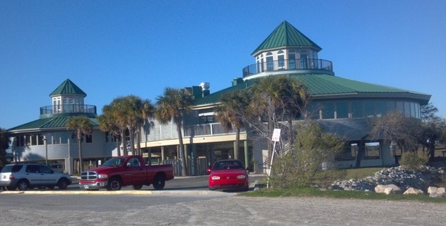
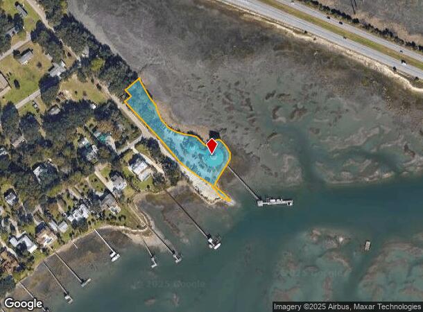
35 Fording Island Road Ext
Hilton Head Island-Bluffton-Beaufort, SC
Buckingham Pltn Commercial Are
R600-041-000-0008-0000
SEA TRAWLER RESTAURANT PB128 P13 ESMT PB128 P14~03/20 SPLIT 0.02 AC 41/304
Restaurantbuilding
Beaufort
2025
South Carolina
2024
1.57 AC
002108
Hilton Head/Beaufort
7,800 SF
Other Market Areas
DEMOGRAPHICS near 35 Fording Island Road Ext
1 Mile
3 Mile
5 Mile
2024 Total Population
1,500
6,982
36,484
2029 Population
1,660
7,721
40,259
Pop Growth 2024-2029
+ 10.67%
+ 10.58%
+ 10.35%
Average Age
43
46
46
2024 Total Households
624
2,901
15,161
HH Growth 2024-2029
+ 10.26%
+ 10.24%
+ 9.99%
Median Household Inc
$60,625
$65,533
$75,051
Avg Household Size
2.30
2.30
2.30
2024 Avg HH Vehicles
2.00
2.00
2.00
Median Home Value
$410,638
$446,033
$446,444
Median Year Built
1998
1997
1996
Nearby Places
- Restaurants
- Banks
- Shops
- Fitness
- Groceries
PUBLIC TRANSPORTATION
AIRPORT
Hilton Head
DRIVE
WALK
Distance
Hilton Head
13 min
7.9 mi
Savannah/Hilton Head International
DRIVE
WALK
Distance
Savannah/Hilton Head International
54 min
37.9 mi
Freight Ports
Georgia Ports - Savannah
DRIVE
WALK
Distance
Georgia Ports - Savannah
49 min
36.3 mi
Nearby Properties
Address
Land Use
TOTAL SIZE
Lot Size
Zoning
Address
Land Use
TOTAL SIZE
Lot Size
Zoning
960 SF
3,900 AC
6106
Address
Land Use
TOTAL SIZE
Lot Size
Zoning
42,800 SF
24.53 AC
6616
Address
Land Use
TOTAL SIZE
Lot Size
Zoning
11,664 SF
28.18 AC
6616
Address
Land Use
TOTAL SIZE
Lot Size
Zoning
17,280 SF
10.77 AC
6616
Address
Land Use
TOTAL SIZE
Lot Size
Zoning
8,808 SF
14.20 AC
6616
Address
Land Use
TOTAL SIZE
Lot Size
Zoning
237,620 SF
13.37 AC
6616
Address
Land Use
TOTAL SIZE
Lot Size
Zoning
69,506 SF
3.24 AC
6616
Address
Land Use
TOTAL SIZE
Lot Size
Zoning
9,004 SF
11.91 AC
6616
Address
Land Use
TOTAL SIZE
Lot Size
Zoning
137,065 SF
26.18 AC
6616
Address
Land Use
TOTAL SIZE
Lot Size
Zoning
25,668 SF
302.85 AC
6616
Address
Land Use
TOTAL SIZE
Lot Size
Zoning
56,708 SF
9.96 AC
6616
Address
Land Use
TOTAL SIZE
Lot Size
Zoning
140,102 SF
10.15 AC
6616
Address
Land Use
TOTAL SIZE
Lot Size
Zoning
16,420 SF
5.75 AC
6616
Address
Land Use
TOTAL SIZE
Lot Size
Zoning
0.49 AC
6106
Address
Land Use
TOTAL SIZE
Lot Size
Zoning
21,000 SF
4.13 AC
6616
Address
Land Use
TOTAL SIZE
Lot Size
Zoning
70,750 SF
5.50 AC
6616
Address
Land Use
TOTAL SIZE
Lot Size
Zoning
7,153 SF
7.22 AC
6615
Address
Land Use
TOTAL SIZE
Lot Size
Zoning
10,280 SF
4.71 AC
6616
Address
Land Use
TOTAL SIZE
Lot Size
Zoning
24,139 SF
3.64 AC
6616
Address
Land Use
TOTAL SIZE
Lot Size
Zoning
8,107 SF
78.54 AC
6816
Address
Land Use
TOTAL SIZE
Lot Size
Zoning
64,718 SF
2.74 AC
6616
Address
Land Use
TOTAL SIZE
Lot Size
Zoning
7,546 SF
4.04 AC
6615
Address
Land Use
TOTAL SIZE
Lot Size
Zoning
34,490 SF
2.67 AC
6616
Address
Land Use
TOTAL SIZE
Lot Size
Zoning
7,140 SF
3.13 AC
6616
Address
Land Use
TOTAL SIZE
Lot Size
Zoning
3,936 SF
4.05 AC
6616
Address
Land Use
TOTAL SIZE
Lot Size
Zoning
5,160 SF
2.98 AC
6615
Address
Land Use
TOTAL SIZE
Lot Size
Zoning
5,292 SF
5.41 AC
6616
Address
Land Use
TOTAL SIZE
Lot Size
Zoning
4,211 SF
1.33 AC
6616
Address
Land Use
TOTAL SIZE
Lot Size
Zoning
15,750 SF
3.37 AC
6616
The World's #1 Commercial Real Estate Marketplace
Connect with us
© 2025 CoStar Group
The information above has been obtained from sources believed reliable. While we do not doubt its accuracy we have not verified it and make no guarantee, warranty or representation about it. It is your responsibility to independently confirm its accuracy and completeness. Any projections, opinions, assumptions, or estimates used are for example only and do not represent the current or future performance of the property. The value of this transaction to you depends on tax and other factors which should be evaluated by your tax, financial, and legal advisors. You and your advisors should conduct a careful, independent investigation of the property to determine to your satisfaction the suitability of the property for your needs.