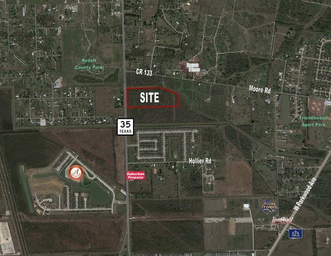
Property Record
133 County Road 133, Alvin, TX 77511
NEARBY LISTINGS FOR SALE OR LEASE
Property Detail
133 County Road 133
Houston-The Woodlands-Sugar Land, TX
I & G N R R
0693-0009-118
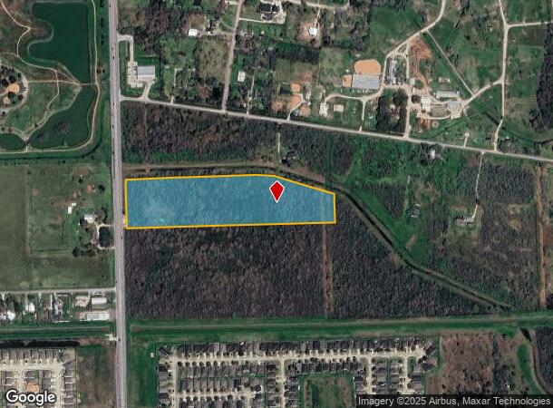
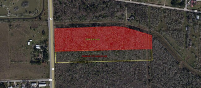
A0693 I & G N R R TRACT 2D-19D ACRES 10.2749
Agriculturalland
Brazoria
AO
Texas
48039C0155K
10.27 AC
2024
NASA/Clear Lake
2025
Houston
661400
DEMOGRAPHICS near 133 County Road 133
1 Mile
3 Mile
5 Mile
2024 Total Population
3,076
20,119
78,336
2029 Population
3,455
22,002
84,890
Pop Growth 2024-2029
+ 12.32%
+ 9.36%
+ 8.37%
Average Age
35
37
38
2024 Total Households
1,033
6,588
26,795
HH Growth 2024-2029
+ 12.39%
+ 9.56%
+ 8.59%
Median Household Inc
$93,004
$93,832
$89,885
Avg Household Size
3.00
3.00
2.80
2024 Avg HH Vehicles
2.00
2.00
2.00
Median Home Value
$243,347
$262,356
$283,750
Median Year Built
2010
1995
1992
Nearby Places
Map Layers
Map Styles
 Street
 Aerial
- Restaurants
- Banks
- Shops
- Fitness
- Groceries
PUBLIC TRANSPORTATION
AIRPORT
William P Hobby
DRIVE
WALK
Distance
William P Hobby
24 min
13.0 mi
Freight Ports
Port of Houston
DRIVE
WALK
Distance
Port of Houston
36 min
21.2 mi
SALE & LEASE HISTORY
LISTING DATE
SALE/LEASE

Nov 12, 2018
For Sale
May 03, 2019
For Sale
Jan 29, 2018
For Sale
Apr 03, 2017
For Sale
Nearby Properties
Address
Land Use
TOTAL SIZE
Lot Size
Zoning
Address
Land Use
TOTAL SIZE
Lot Size
Zoning
40.52 AC
0017
Address
Land Use
TOTAL SIZE
Lot Size
Zoning
65,935 SF
81.27 AC
Address
Land Use
TOTAL SIZE
Lot Size
Zoning
84,272 SF
16.93 AC
Address
Land Use
TOTAL SIZE
Lot Size
Zoning
197,506 SF
20.52 AC
Address
Land Use
TOTAL SIZE
Lot Size
Zoning
68,435 SF
5.62 AC
0041
Address
Land Use
TOTAL SIZE
Lot Size
Zoning
111,370 SF
11.10 AC
Address
Land Use
TOTAL SIZE
Lot Size
Zoning
90,044 SF
9.62 AC
Address
Land Use
TOTAL SIZE
Lot Size
Zoning
56,905 SF
7 AC
Address
Land Use
TOTAL SIZE
Lot Size
Zoning
Address
Land Use
TOTAL SIZE
Lot Size
Zoning
136,700 SF
9.91 AC
0095
Address
Land Use
TOTAL SIZE
Lot Size
Zoning
147,939 SF
38.36 AC
0026
Address
Land Use
TOTAL SIZE
Lot Size
Zoning
89,466 SF
8.61 AC
0109
Address
Land Use
TOTAL SIZE
Lot Size
Zoning
36,596 SF
14.75 AC
Address
Land Use
TOTAL SIZE
Lot Size
Zoning
22,144 SF
9.27 AC
Address
Land Use
TOTAL SIZE
Lot Size
Zoning
1,920 SF
14.94 AC
Address
Land Use
TOTAL SIZE
Lot Size
Zoning
74,002 SF
9.58 AC
Address
Land Use
TOTAL SIZE
Lot Size
Zoning
63,530 SF
8.89 AC
0022
Address
Land Use
TOTAL SIZE
Lot Size
Zoning
94,809 SF
49.01 AC
0103
Address
Land Use
TOTAL SIZE
Lot Size
Zoning
145 SF
20.24 AC
0037
Address
Land Use
TOTAL SIZE
Lot Size
Zoning
18,800 SF
1.08 AC
Address
Land Use
TOTAL SIZE
Lot Size
Zoning
29,200 SF
3.19 AC
Address
Land Use
TOTAL SIZE
Lot Size
Zoning
140 SF
25.06 AC
0008
Address
Land Use
TOTAL SIZE
Lot Size
Zoning
63,250 SF
6.51 AC
0101
Address
Land Use
TOTAL SIZE
Lot Size
Zoning
29.04 AC
0001
Address
Land Use
TOTAL SIZE
Lot Size
Zoning
1,739 SF
5.20 AC
Address
Land Use
TOTAL SIZE
Lot Size
Zoning
22,625 SF
7 AC
Address
Land Use
TOTAL SIZE
Lot Size
Zoning
14.09 AC
Address
Land Use
TOTAL SIZE
Lot Size
Zoning
12,868 SF
1.65 AC
Address
Land Use
TOTAL SIZE
Lot Size
Zoning
94,300 SF
5 AC
Address
Land Use
TOTAL SIZE
Lot Size
Zoning
2,169 SF
9.57 AC
SFR
The World's #1 Commercial Real Estate Marketplace
Connect with us
© 2025 CoStar Group
The information above has been obtained from sources believed reliable. While we do not doubt its accuracy we have not verified it and make no guarantee, warranty or representation about it. It is your responsibility to independently confirm its accuracy and completeness. Any projections, opinions, assumptions, or estimates used are for example only and do not represent the current or future performance of the property. The value of this transaction to you depends on tax and other factors which should be evaluated by your tax, financial, and legal advisors. You and your advisors should conduct a careful, independent investigation of the property to determine to your satisfaction the suitability of the property for your needs.