Property Record
35 Industrial Rd, Elizabethtown, PA 17022
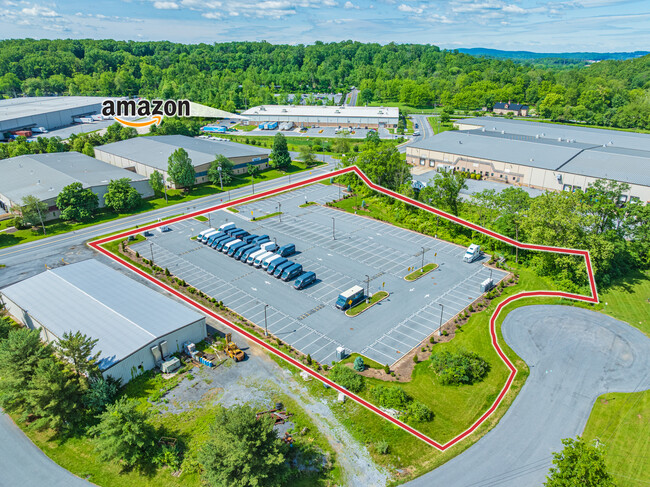
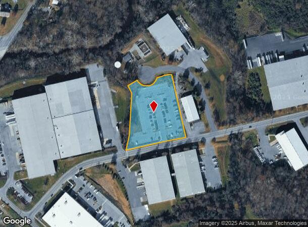
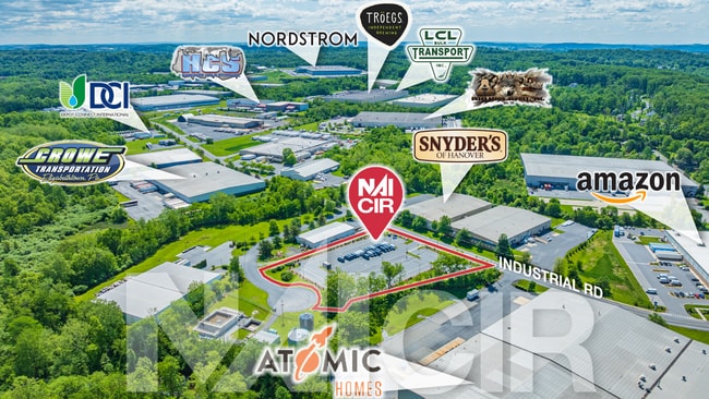
This Property Is For Sale
NEARBY LISTINGS FOR SALE OR LEASE
-
-
View all Elizabethtown listings for sale on LoopNet.com
Property Detail
35 Industrial Rd
160-28585-0-0000
Conewago Industrial Park Associates
Industrialacreage
Lancaster
X
Pennsylvania
42071C0092F
2.55 AC
2024
Lancaster County
2025
Philadelphia
010803
Lancaster, PA
DEMOGRAPHICS near 35 Industrial Rd
1 Mile
3 Mile
5 Mile
2024 Total Population
742
12,938
46,781
2029 Population
753
13,100
47,363
Pop Growth 2024-2029
+ 1.48%
+ 1.25%
+ 1.24%
Average Age
41
47
42
2024 Total Households
274
5,349
18,478
HH Growth 2024-2029
+ 1.46%
+ 1.25%
+ 1.35%
Median Household Inc
$98,749
$63,122
$69,958
Avg Household Size
2.60
2.30
2.40
2024 Avg HH Vehicles
2.00
2.00
2.00
Median Home Value
$268,084
$225,733
$215,508
Median Year Built
1981
1983
1974
Nearby Places
Map Layers
Map Styles
 Street
 Aerial
- Restaurants
- Banks
- Shops
- Fitness
- Groceries
PUBLIC TRANSPORTATION
COMMUTER RAIL
Elizabethtown Amtrak Station (Keystone Service - Amtrak, Pennsylvanian - Amtrak)
DRIVE
WALK
Distance
Elizabethtown Amtrak Station (Keystone Service - Amtrak, Pennsylvanian - Amtrak)
9 min
3.9 mi
Middletown (Keystone Service - Amtrak)
DRIVE
WALK
Distance
Middletown (Keystone Service - Amtrak)
13 min
6.7 mi
AIRPORT
Harrisburg International
DRIVE
WALK
Distance
Harrisburg International
17 min
8.3 mi
Freight Ports
Port of Baltimore
DRIVE
WALK
Distance
Port of Baltimore
121 min
82.2 mi
Nearby Properties
Address
Land Use
TOTAL SIZE
Lot Size
Zoning
Address
Land Use
TOTAL SIZE
Lot Size
Zoning
1,506,831 SF
1,061.90 AC
INS
Address
Land Use
TOTAL SIZE
Lot Size
Zoning
531,244 SF
100.20 AC
Address
Land Use
TOTAL SIZE
Lot Size
Zoning
705,686 SF
90.80 AC
Address
Land Use
TOTAL SIZE
Lot Size
Zoning
196.27 AC
Address
Land Use
TOTAL SIZE
Lot Size
Zoning
991,031 SF
91.47 AC
Address
Land Use
TOTAL SIZE
Lot Size
Zoning
2,603 SF
93.78 AC
Address
Land Use
TOTAL SIZE
Lot Size
Zoning
2,160 SF
72.40 AC
Address
Land Use
TOTAL SIZE
Lot Size
Zoning
113,000 SF
19.61 AC
Address
Land Use
TOTAL SIZE
Lot Size
Zoning
218,686 SF
6.79 AC
MU
Address
Land Use
TOTAL SIZE
Lot Size
Zoning
139,528 SF
32.10 AC
Address
Land Use
TOTAL SIZE
Lot Size
Zoning
267,696 SF
33.78 AC
Address
Land Use
TOTAL SIZE
Lot Size
Zoning
320,000 SF
27.99 AC
Address
Land Use
TOTAL SIZE
Lot Size
Zoning
85,268 SF
34.90 AC
Address
Land Use
TOTAL SIZE
Lot Size
Zoning
303,449 SF
42.16 AC
I
Address
Land Use
TOTAL SIZE
Lot Size
Zoning
165,600 SF
19.17 AC
Address
Land Use
TOTAL SIZE
Lot Size
Zoning
172,116 SF
248 AC
IN
Address
Land Use
TOTAL SIZE
Lot Size
Zoning
144,000 SF
22.46 AC
I
Address
Land Use
TOTAL SIZE
Lot Size
Zoning
199,888 SF
17 AC
I
Address
Land Use
TOTAL SIZE
Lot Size
Zoning
127,425 SF
12.69 AC
Address
Land Use
TOTAL SIZE
Lot Size
Zoning
206,236 SF
13.70 AC
I
Address
Land Use
TOTAL SIZE
Lot Size
Zoning
201,594 SF
11.20 AC
I
Address
Land Use
TOTAL SIZE
Lot Size
Zoning
100,368 SF
7.71 AC
Address
Land Use
TOTAL SIZE
Lot Size
Zoning
23,170 SF
107.91 AC
R
Address
Land Use
TOTAL SIZE
Lot Size
Zoning
41,069 SF
3.12 AC
R1
Address
Land Use
TOTAL SIZE
Lot Size
Zoning
2,800 SF
81.99 AC
Address
Land Use
TOTAL SIZE
Lot Size
Zoning
98,724 SF
11.90 AC
I
Address
Land Use
TOTAL SIZE
Lot Size
Zoning
31,445 SF
10.70 AC
INS
Address
Land Use
TOTAL SIZE
Lot Size
Zoning
71,550 SF
7.05 AC
Address
Land Use
TOTAL SIZE
Lot Size
Zoning
53,048 SF
5 AC
R-2
Address
Land Use
TOTAL SIZE
Lot Size
Zoning
69,355 SF
13.56 AC
The World's #1 Commercial Real Estate Marketplace
Connect with us
© 2026 CoStar Group
The information above has been obtained from sources believed reliable. While we do not doubt its accuracy we have not verified it and make no guarantee, warranty or representation about it. It is your responsibility to independently confirm its accuracy and completeness. Any projections, opinions, assumptions, or estimates used are for example only and do not represent the current or future performance of the property. The value of this transaction to you depends on tax and other factors which should be evaluated by your tax, financial, and legal advisors. You and your advisors should conduct a careful, independent investigation of the property to determine to your satisfaction the suitability of the property for your needs.