Property Record
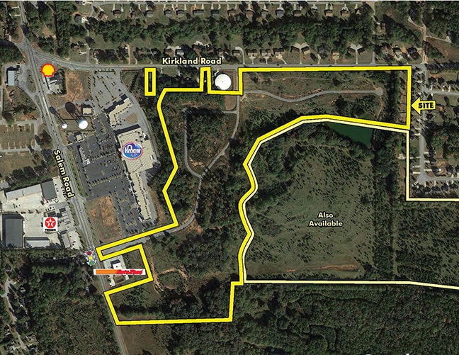
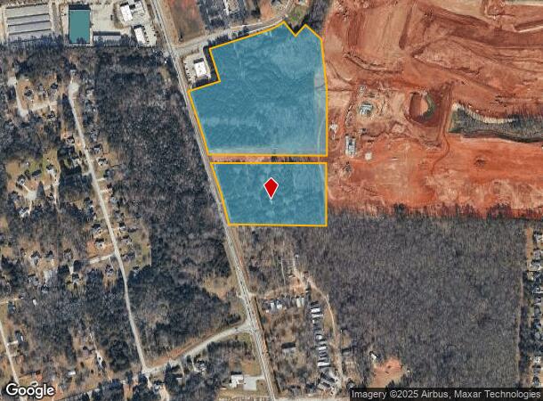
35 Kirkland Rd, Covington, GA 30016
NEARBY LISTINGS FOR SALE OR LEASE
Property Detail
35 Kirkland Rd
Atlanta-Sandy Springs-Roswell, GA
R5 Misc Land - Area 6
0013000000046000
25.71 AC KIRKLAND/SALEM RD
Residentialacreage
Newton
X
Georgia
13217C0105D
25.71 AC
2025
Newton County
2025
Atlanta
100902
DEMOGRAPHICS near 35 Kirkland Rd
1 mile
3 mile
5 mile
2024 Total Population
8,781
49,467
92,818
2029 Population
9,660
53,434
99,759
Pop Growth 2024-2029
+ 10.01%
+ 8.02%
+ 7.48%
Average Age
36
38
38
2024 Total Households
3,213
17,035
32,609
HH Growth 2024-2029
+ 10.30%
+ 8.21%
+ 7.62%
Median Household Inc
$52,064
$72,820
$71,839
Avg Household Size
2.70
2.90
2.80
2024 Avg HH Vehicles
2.00
2.00
2.00
Median Home Value
$183,199
$198,101
$193,282
Median Year Built
1998
1997
1994
Nearby Places
Map Layers
Map Styles
 Street
 Aerial
Transit
 Traffic
 Biking
Places
Listings with unknown addresses are not visible on the map
- Restaurants
- Banks
- Shops
- Fitness
- Groceries
PUBLIC TRANSPORTATION
AIRPORT
Hartsfield - Jackson Atlanta International
Drive
Walk
Distance
Hartsfield - Jackson Atlanta International
46 min
34.2 mi
Freight Ports
Georgia Ports - Savannah
Drive
Walk
Distance
Georgia Ports - Savannah
273 min
236.7 mi
Nearby Properties
Address
Land Use
TOTAL SIZE
Lot Size
Zoning
Address
Land Use
TOTAL SIZE
Lot Size
Zoning
1,158,095 SF
161.26 AC
Address
Land Use
TOTAL SIZE
Lot Size
Zoning
1,158,095 SF
0.01 AC
Address
Land Use
TOTAL SIZE
Lot Size
Zoning
4,734 SF
35.19 AC
RMF
Address
Land Use
TOTAL SIZE
Lot Size
Zoning
4,162 SF
37.52 AC
R3
Address
Land Use
TOTAL SIZE
Lot Size
Zoning
306,886 SF
118.50 AC
R2
Address
Land Use
TOTAL SIZE
Lot Size
Zoning
1,648 SF
25.08 AC
C1
Address
Land Use
TOTAL SIZE
Lot Size
Zoning
882,960 SF
0.01 AC
Address
Land Use
TOTAL SIZE
Lot Size
Zoning
175,605 SF
39.99 AC
AR
Address
Land Use
TOTAL SIZE
Lot Size
Zoning
17,056 SF
16.78 AC
C1
Address
Land Use
TOTAL SIZE
Lot Size
Zoning
131,111 SF
22.17 AC
R3
Address
Land Use
TOTAL SIZE
Lot Size
Zoning
5,160 SF
45.17 AC
C1
Address
Land Use
TOTAL SIZE
Lot Size
Zoning
882,960 SF
114.02 AC
M1
Address
Land Use
TOTAL SIZE
Lot Size
Zoning
8,156 SF
14.49 AC
C1
Address
Land Use
TOTAL SIZE
Lot Size
Zoning
8,832 SF
8.26 AC
C1
Address
Land Use
TOTAL SIZE
Lot Size
Zoning
8,632 SF
8.11 AC
C1
Address
Land Use
TOTAL SIZE
Lot Size
Zoning
77,016 SF
15.28 AC
C2
Address
Land Use
TOTAL SIZE
Lot Size
Zoning
82,716 SF
21.04 AC
R2
Address
Land Use
TOTAL SIZE
Lot Size
Zoning
125,971 SF
23.84 AC
C1
Address
Land Use
TOTAL SIZE
Lot Size
Zoning
130,000 SF
33.48 AC
R1
Address
Land Use
TOTAL SIZE
Lot Size
Zoning
65,360 SF
75.51 AC
E6
Address
Land Use
TOTAL SIZE
Lot Size
Zoning
65,520 SF
35 AC
E6
Address
Land Use
TOTAL SIZE
Lot Size
Zoning
65,008 SF
23.81 AC
R2
Address
Land Use
TOTAL SIZE
Lot Size
Zoning
19,197 SF
9.72 AC
R3
Address
Land Use
TOTAL SIZE
Lot Size
Zoning
151,955 SF
26.17 AC
R1
Address
Land Use
TOTAL SIZE
Lot Size
Zoning
64,799 SF
19.10 AC
E6
Address
Land Use
TOTAL SIZE
Lot Size
Zoning
2,460 SF
7 AC
E2
Address
Land Use
TOTAL SIZE
Lot Size
Zoning
11,294 SF
7.63 AC
C1
Address
Land Use
TOTAL SIZE
Lot Size
Zoning
18,648 SF
2.48 AC
C1
Address
Land Use
TOTAL SIZE
Lot Size
Zoning
81,591 SF
12.80 AC
C2
Address
Land Use
TOTAL SIZE
Lot Size
Zoning
66,660 SF
12.80 AC
C1
The World's #1 Commercial Real Estate Marketplace
Connect with us
© 2026 CoStar Group
The information above has been obtained from sources believed reliable. While we do not doubt its accuracy we have not verified it and make no guarantee, warranty or representation about it. It is your responsibility to independently confirm its accuracy and completeness. Any projections, opinions, assumptions, or estimates used are for example only and do not represent the current or future performance of the property. The value of this transaction to you depends on tax and other factors which should be evaluated by your tax, financial, and legal advisors. You and your advisors should conduct a careful, independent investigation of the property to determine to your satisfaction the suitability of the property for your needs.