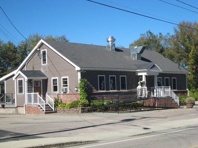
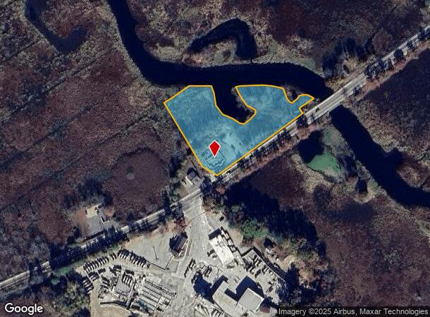
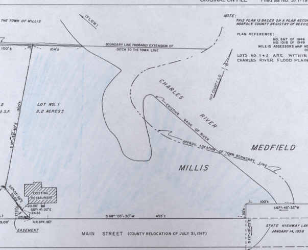
Property Record
35 Main St, Millis, MA 02054
NEARBY LISTINGS FOR SALE OR LEASE
Property Detail
35 Main St
Officebuilding
Norfolk
AE
Massachusetts
25021C0162F
3.20 AC
2025
I-95 Corridor South
2025
Boston
407102
Boston-Cambridge-Newton, MA-NH
2,264 SF
MILL-000027-000000-000010
DEMOGRAPHICS near 35 Main St
1 Mile
3 Mile
5 Mile
2024 Total Population
2,434
21,036
62,988
2029 Population
2,435
20,976
63,013
Pop Growth 2024-2029
+ 0.04%
(0.29%)
+ 0.04%
Average Age
41
41
41
2024 Total Households
932
7,500
22,292
HH Growth 2024-2029
0.00%
(0.29%)
+ 0.09%
Median Household Inc
$133,059
$165,862
$164,070
Avg Household Size
2.60
2.80
2.80
2024 Avg HH Vehicles
2.00
2.00
2.00
Median Home Value
$699,644
$723,440
$697,906
Median Year Built
1968
1973
1974
Nearby Places
Map Layers
Map Styles
 Street
 Aerial
- Restaurants
- Banks
- Shops
- Fitness
- Groceries
PUBLIC TRANSPORTATION
COMMUTER RAIL
Walpole (Foxboro Line (Special Events Only) - Massachusetts Bay Transportation Authority Commuter Rail (Purple Line), Franklin Line - Massachusetts Bay Transportation Authority Commuter Rail (Purple Line))
DRIVE
WALK
Distance
Walpole (Foxboro Line (Special Events Only) - Massachusetts Bay Transportation Authority Commuter Rail (Purple Line), Franklin Line - Massachusetts Bay Transportation Authority Commuter Rail (Purple Line))
10 min
5.3 mi
Norfolk (Franklin Line - Massachusetts Bay Transportation Authority Commuter Rail (Purple Line))
DRIVE
WALK
Distance
Norfolk (Franklin Line - Massachusetts Bay Transportation Authority Commuter Rail (Purple Line))
10 min
5.6 mi
AIRPORT
General Edward Lawrence Logan International
DRIVE
WALK
Distance
General Edward Lawrence Logan International
43 min
24.2 mi
Worcester Regional
DRIVE
WALK
Distance
Worcester Regional
61 min
37.6 mi
Rhode Island Tf Green International
DRIVE
WALK
Distance
Rhode Island Tf Green International
63 min
40.7 mi
Freight Ports
Port of Boston
DRIVE
WALK
Distance
Port of Boston
42 min
22.6 mi
Nearby Properties
Address
Land Use
TOTAL SIZE
Lot Size
Zoning
Address
Land Use
TOTAL SIZE
Lot Size
Zoning
61.50 AC
RS
Address
Land Use
TOTAL SIZE
Lot Size
Zoning
146,536 SF
3.30 AC
Address
Land Use
TOTAL SIZE
Lot Size
Zoning
36.60 AC
R2
Address
Land Use
TOTAL SIZE
Lot Size
Zoning
138,644 SF
12.89 AC
Address
Land Use
TOTAL SIZE
Lot Size
Zoning
16.98 AC
RS
Address
Land Use
TOTAL SIZE
Lot Size
Zoning
12.65 AC
B
Address
Land Use
TOTAL SIZE
Lot Size
Zoning
87.30 AC
A
Address
Land Use
TOTAL SIZE
Lot Size
Zoning
28,080 SF
2.80 AC
RU
Address
Land Use
TOTAL SIZE
Lot Size
Zoning
89,572 SF
4.50 AC
RS
Address
Land Use
TOTAL SIZE
Lot Size
Zoning
91,891 SF
10.03 AC
B
Address
Land Use
TOTAL SIZE
Lot Size
Zoning
157.50 AC
Address
Land Use
TOTAL SIZE
Lot Size
Zoning
65,190 SF
44.25 AC
RE
Address
Land Use
TOTAL SIZE
Lot Size
Zoning
12,960 SF
3.89 AC
RS
Address
Land Use
TOTAL SIZE
Lot Size
Zoning
14.91 AC
RU
Address
Land Use
TOTAL SIZE
Lot Size
Zoning
83,772 SF
7.69 AC
Address
Land Use
TOTAL SIZE
Lot Size
Zoning
117,230 SF
12.08 AC
IE
Address
Land Use
TOTAL SIZE
Lot Size
Zoning
80,860 SF
8.77 AC
Address
Land Use
TOTAL SIZE
Lot Size
Zoning
121.74 AC
R2
Address
Land Use
TOTAL SIZE
Lot Size
Zoning
4,480 SF
21.61 AC
RE
Address
Land Use
TOTAL SIZE
Lot Size
Zoning
71,001 SF
9.33 AC
Address
Land Use
TOTAL SIZE
Lot Size
Zoning
186.89 AC
RT
Address
Land Use
TOTAL SIZE
Lot Size
Zoning
24.42 AC
R2
Address
Land Use
TOTAL SIZE
Lot Size
Zoning
2,108 SF
3.20 AC
Address
Land Use
TOTAL SIZE
Lot Size
Zoning
182.58 AC
RT
Address
Land Use
TOTAL SIZE
Lot Size
Zoning
28,342 SF
3.18 AC
B
Address
Land Use
TOTAL SIZE
Lot Size
Zoning
6.78 AC
RU
Address
Land Use
TOTAL SIZE
Lot Size
Zoning
34,867 SF
3.10 AC
Address
Land Use
TOTAL SIZE
Lot Size
Zoning
1.35 AC
RS
Address
Land Use
TOTAL SIZE
Lot Size
Zoning
0.94 AC
B
Address
Land Use
TOTAL SIZE
Lot Size
Zoning
11,085 SF
1.40 AC
The World's #1 Commercial Real Estate Marketplace
Connect with us
© 2026 CoStar Group
The information above has been obtained from sources believed reliable. While we do not doubt its accuracy we have not verified it and make no guarantee, warranty or representation about it. It is your responsibility to independently confirm its accuracy and completeness. Any projections, opinions, assumptions, or estimates used are for example only and do not represent the current or future performance of the property. The value of this transaction to you depends on tax and other factors which should be evaluated by your tax, financial, and legal advisors. You and your advisors should conduct a careful, independent investigation of the property to determine to your satisfaction the suitability of the property for your needs.