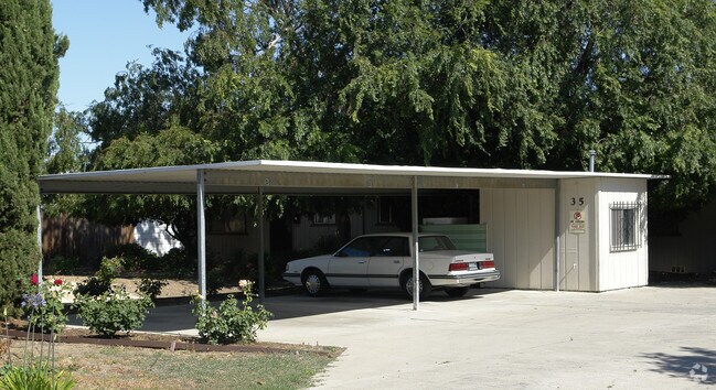
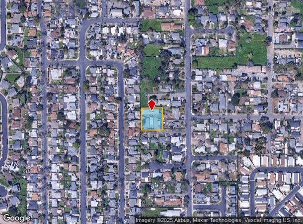
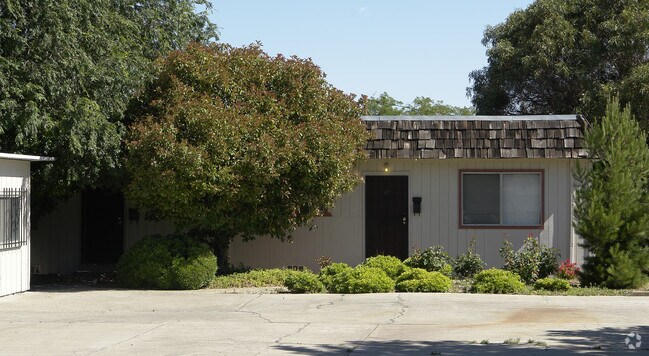
Property Record
35 Roberts St, Bay Point, CA 94565

NEARBY LISTINGS FOR SALE OR LEASE
-
-
View all Bay Point listings for sale on LoopNet.com
Property Detail
35 Roberts St
095-074-008-4
PARCEL MAP 21 PG 33 PCL B
Quadruplex
Contra Costa
X
California
06095C0695F
0.40 AC
2025
Bay Point
2025
East Bay/Oakland
314106
Oakland-Fremont-Berkeley, CA
3,376 SF
DEMOGRAPHICS near 35 Roberts St
1 Mile
3 Mile
5 Mile
2024 Total Population
18,600
78,081
128,941
2029 Population
18,525
77,931
128,311
Pop Growth 2024-2029
(0.40%)
(0.19%)
(0.49%)
Average Age
37
37
38
2024 Total Households
5,500
23,108
40,347
HH Growth 2024-2029
(0.44%)
(0.25%)
(0.57%)
Median Household Inc
$88,020
$85,148
$94,222
Avg Household Size
3.30
3.30
3.10
2024 Avg HH Vehicles
2.00
2.00
2.00
Median Home Value
$450,985
$522,923
$613,822
Median Year Built
1980
1983
1978
Nearby Places
Map Layers
Map Styles
 Street
 Aerial
- Restaurants
- Banks
- Shops
- Fitness
- Groceries
PUBLIC TRANSPORTATION
COMMUTER RAIL
DRIVE
WALK
Distance
15 min
9.0 mi
AIRPORT
Metro Oakland International
DRIVE
WALK
Distance
Metro Oakland International
51 min
37.5 mi
San Francisco International
DRIVE
WALK
Distance
San Francisco International
68 min
49.4 mi
Freight Ports
Port of Oakland
DRIVE
WALK
Distance
Port of Oakland
40 min
30.2 mi
Nearby Properties
Address
Land Use
TOTAL SIZE
Lot Size
Zoning
Address
Land Use
TOTAL SIZE
Lot Size
Zoning
29.68 AC
Address
Land Use
TOTAL SIZE
Lot Size
Zoning
516,154 SF
25.09 AC
Address
Land Use
TOTAL SIZE
Lot Size
Zoning
32,729 SF
7.61 AC
Address
Land Use
TOTAL SIZE
Lot Size
Zoning
157,250 SF
3.94 AC
Address
Land Use
TOTAL SIZE
Lot Size
Zoning
187,532 SF
10.55 AC
Address
Land Use
TOTAL SIZE
Lot Size
Zoning
9,215 SF
14.73 AC
P1
Address
Land Use
TOTAL SIZE
Lot Size
Zoning
15,000 SF
8.33 AC
P1
Address
Land Use
TOTAL SIZE
Lot Size
Zoning
4,312 SF
10.18 AC
Address
Land Use
TOTAL SIZE
Lot Size
Zoning
25.11 AC
P1
Address
Land Use
TOTAL SIZE
Lot Size
Zoning
7,678 SF
1.89 AC
Address
Land Use
TOTAL SIZE
Lot Size
Zoning
74,045 SF
3.25 AC
Address
Land Use
TOTAL SIZE
Lot Size
Zoning
204,831 SF
9.08 AC
Address
Land Use
TOTAL SIZE
Lot Size
Zoning
66,039 SF
2.33 AC
Address
Land Use
TOTAL SIZE
Lot Size
Zoning
420,048 SF
23.71 AC
Address
Land Use
TOTAL SIZE
Lot Size
Zoning
224,132 SF
17.21 AC
Address
Land Use
TOTAL SIZE
Lot Size
Zoning
112,736 SF
1.78 AC
Address
Land Use
TOTAL SIZE
Lot Size
Zoning
6,650 SF
11.70 AC
M29
Address
Land Use
TOTAL SIZE
Lot Size
Zoning
11,588 SF
3.65 AC
P1
Address
Land Use
TOTAL SIZE
Lot Size
Zoning
13,552 SF
10.28 AC
Address
Land Use
TOTAL SIZE
Lot Size
Zoning
4,992 SF
15.14 AC
T1
Address
Land Use
TOTAL SIZE
Lot Size
Zoning
230.81 AC
Address
Land Use
TOTAL SIZE
Lot Size
Zoning
680 SF
2.68 AC
Address
Land Use
TOTAL SIZE
Lot Size
Zoning
497.19 AC
Address
Land Use
TOTAL SIZE
Lot Size
Zoning
118,536 SF
3.86 AC
P-1
Address
Land Use
TOTAL SIZE
Lot Size
Zoning
44,700 SF
32.28 AC
P1
Address
Land Use
TOTAL SIZE
Lot Size
Zoning
833.20 AC
A3
Address
Land Use
TOTAL SIZE
Lot Size
Zoning
63,842 SF
6.22 AC
R12
Address
Land Use
TOTAL SIZE
Lot Size
Zoning
14,796 SF
2.17 AC
P1
Address
Land Use
TOTAL SIZE
Lot Size
Zoning
104,732 SF
5.99 AC
P1
Address
Land Use
TOTAL SIZE
Lot Size
Zoning
22.60 AC
The World's #1 Commercial Real Estate Marketplace
Connect with us
© 2026 CoStar Group
The information above has been obtained from sources believed reliable. While we do not doubt its accuracy we have not verified it and make no guarantee, warranty or representation about it. It is your responsibility to independently confirm its accuracy and completeness. Any projections, opinions, assumptions, or estimates used are for example only and do not represent the current or future performance of the property. The value of this transaction to you depends on tax and other factors which should be evaluated by your tax, financial, and legal advisors. You and your advisors should conduct a careful, independent investigation of the property to determine to your satisfaction the suitability of the property for your needs.