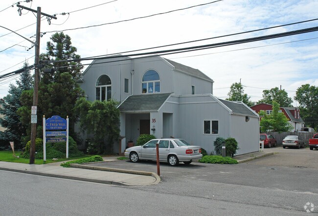
Property Record
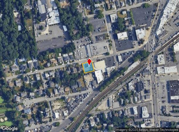
35 Roosevelt Ave, Syosset, NY 11791

NEARBY LISTINGS FOR SALE OR LEASE
Property Detail
35 Roosevelt Ave
2489-15-013-00-0123-0
123
Commercialnec
Nassau
X
New York
36059C0134G
123
2025
0.23 AC
2025
Eastern Nassau
518300
Long Island (New York)
5,374 SF
Nassau County-Suffolk County, NY
DEMOGRAPHICS near 35 Roosevelt Ave
1 Mile
3 Mile
5 Mile
2024 Total Population
11,079
60,812
167,339
2029 Population
10,952
60,133
164,767
Pop Growth 2024-2029
(1.15%)
(1.12%)
(1.54%)
Average Age
42
43
42
2024 Total Households
3,507
19,484
53,639
HH Growth 2024-2029
(1.28%)
(1.21%)
(1.62%)
Median Household Inc
$164,803
$171,086
$149,001
Avg Household Size
3.10
3.00
3.00
2024 Avg HH Vehicles
2.00
2.00
2.00
Median Home Value
$833,375
$820,158
$762,489
Median Year Built
1965
1960
1958
Nearby Places
- Restaurants
- Banks
- Shops
- Fitness
- Groceries
PUBLIC TRANSPORTATION
COMMUTER RAIL
Syosset Station (Port Jefferson Branch - Long Island Rail Road)
DRIVE
WALK
Distance
Syosset Station (Port Jefferson Branch - Long Island Rail Road)
2 min
8 min
0.4 mi
Cold Spring Harbor Station (Port Jefferson Branch - Long Island Rail Road)
DRIVE
WALK
Distance
Cold Spring Harbor Station (Port Jefferson Branch - Long Island Rail Road)
8 min
3.5 mi
AIRPORT
John F Kennedy International
DRIVE
WALK
Distance
John F Kennedy International
39 min
23.7 mi
LaGuardia
DRIVE
WALK
Distance
LaGuardia
37 min
23.8 mi
Westchester County
DRIVE
WALK
Distance
Westchester County
66 min
44.2 mi
Freight Ports
NY - Red Hook Container Terminal
DRIVE
WALK
Distance
NY - Red Hook Container Terminal
48 min
31.9 mi
Nearby Properties
Address
Land Use
TOTAL SIZE
Lot Size
Zoning
Address
Land Use
TOTAL SIZE
Lot Size
Zoning
Address
Land Use
TOTAL SIZE
Lot Size
Zoning
Address
Land Use
TOTAL SIZE
Lot Size
Zoning
Address
Land Use
TOTAL SIZE
Lot Size
Zoning
55,780 SF
64 AC
Address
Land Use
TOTAL SIZE
Lot Size
Zoning
Address
Land Use
TOTAL SIZE
Lot Size
Zoning
178,486 SF
53.25 AC
Address
Land Use
TOTAL SIZE
Lot Size
Zoning
469,586 SF
53.14 AC
Address
Land Use
TOTAL SIZE
Lot Size
Zoning
800 SF
45.25 AC
Address
Land Use
TOTAL SIZE
Lot Size
Zoning
300,526 SF
44.30 AC
Address
Land Use
TOTAL SIZE
Lot Size
Zoning
75,253 SF
44.28 AC
Address
Land Use
TOTAL SIZE
Lot Size
Zoning
160 SF
241.23 AC
Address
Land Use
TOTAL SIZE
Lot Size
Zoning
Address
Land Use
TOTAL SIZE
Lot Size
Zoning
2,555 SF
284.67 AC
Address
Land Use
TOTAL SIZE
Lot Size
Zoning
Address
Land Use
TOTAL SIZE
Lot Size
Zoning
534,840 SF
26.15 AC
Address
Land Use
TOTAL SIZE
Lot Size
Zoning
Address
Land Use
TOTAL SIZE
Lot Size
Zoning
29,574 SF
174.23 AC
Address
Land Use
TOTAL SIZE
Lot Size
Zoning
146,287 SF
48.63 AC
Address
Land Use
TOTAL SIZE
Lot Size
Zoning
77,284 SF
40.86 AC
Address
Land Use
TOTAL SIZE
Lot Size
Zoning
159,471 SF
28.50 AC
Address
Land Use
TOTAL SIZE
Lot Size
Zoning
Address
Land Use
TOTAL SIZE
Lot Size
Zoning
220,367 SF
24 AC
Address
Land Use
TOTAL SIZE
Lot Size
Zoning
177,109 SF
23.78 AC
Address
Land Use
TOTAL SIZE
Lot Size
Zoning
66,061 SF
18.79 AC
Address
Land Use
TOTAL SIZE
Lot Size
Zoning
83.59 AC
Address
Land Use
TOTAL SIZE
Lot Size
Zoning
Address
Land Use
TOTAL SIZE
Lot Size
Zoning
28,537 SF
5.21 AC
Address
Land Use
TOTAL SIZE
Lot Size
Zoning
147,175 SF
10.28 AC
Address
Land Use
TOTAL SIZE
Lot Size
Zoning
204,726 SF
28.34 AC
Address
Land Use
TOTAL SIZE
Lot Size
Zoning
546,788 SF
21.16 AC
The World's #1 Commercial Real Estate Marketplace
Connect with us
© 2025 CoStar Group
The information above has been obtained from sources believed reliable. While we do not doubt its accuracy we have not verified it and make no guarantee, warranty or representation about it. It is your responsibility to independently confirm its accuracy and completeness. Any projections, opinions, assumptions, or estimates used are for example only and do not represent the current or future performance of the property. The value of this transaction to you depends on tax and other factors which should be evaluated by your tax, financial, and legal advisors. You and your advisors should conduct a careful, independent investigation of the property to determine to your satisfaction the suitability of the property for your needs.