Property Record
35 S I Service Rd, Moore, OK 73160
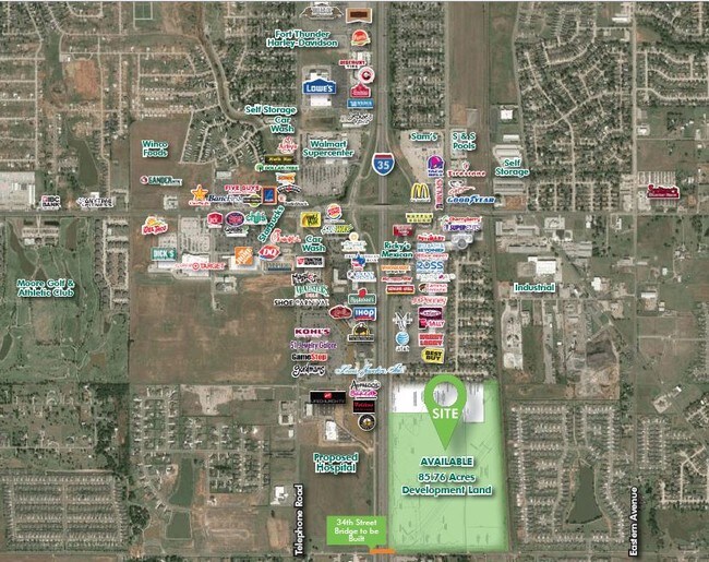
NEARBY LISTINGS FOR SALE OR LEASE
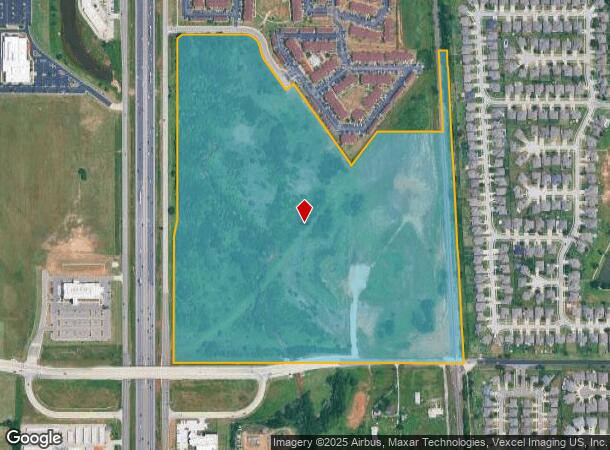
Property Detail
35 S I Service Rd
R0174142
26-10-3W 70.80 AC PRT E/2 SW/4 & SE/4 BEG 1540.65E SW/C N812.05 N 11D E101.98 N1232.02 E1071.95 S 03D W156.17 E319.94 N655.93 E231.11 S2643.72 W1795.57 POB LESS BEG 305.59E NW/C SE/4 E231.18 S 03D E656.91 W266.92 N655.93 POB LESS BEG 1540.66E 500S 42
Agriculturalland
Cleveland
AE
Oklahoma
40027C0190K
70.80 AC
2024
Norman
2024
Oklahoma City
202102
Oklahoma City, OK
DEMOGRAPHICS near 35 S I Service Rd
1 Mile
3 Mile
5 Mile
2024 Total Population
6,837
62,328
129,921
2029 Population
6,986
64,525
135,098
Pop Growth 2024-2029
+ 2.18%
+ 3.52%
+ 3.98%
Average Age
36
37
38
2024 Total Households
2,714
23,286
50,049
HH Growth 2024-2029
+ 2.32%
+ 3.69%
+ 4.21%
Median Household Inc
$79,193
$75,234
$76,035
Avg Household Size
2.50
2.60
2.50
2024 Avg HH Vehicles
2.00
2.00
2.00
Median Home Value
$225,000
$173,566
$192,045
Median Year Built
2010
1996
1996
Nearby Places
Map Layers
Map Styles
 Street
 Aerial
- Restaurants
- Banks
- Shops
- Fitness
- Groceries
PUBLIC TRANSPORTATION
COMMUTER RAIL
Norman Amtrak Station (Heartland Flyer - Amtrak)
DRIVE
WALK
Distance
Norman Amtrak Station (Heartland Flyer - Amtrak)
16 min
7.9 mi
AIRPORT
Will Rogers World
DRIVE
WALK
Distance
Will Rogers World
26 min
14.2 mi
Freight Ports
Tulsa Port Of Catoosa
DRIVE
WALK
Distance
Tulsa Port Of Catoosa
147 min
133.5 mi
SALE & LEASE HISTORY
LISTING DATE
SALE/LEASE

Sep 24, 2016
For Sale
Nearby Properties
Address
Land Use
TOTAL SIZE
Lot Size
Zoning
Address
Land Use
TOTAL SIZE
Lot Size
Zoning
146,265 SF
16.85 AC
Address
Land Use
TOTAL SIZE
Lot Size
Zoning
210,816 SF
10.45 AC
Address
Land Use
TOTAL SIZE
Lot Size
Zoning
45.01 AC
Address
Land Use
TOTAL SIZE
Lot Size
Zoning
Address
Land Use
TOTAL SIZE
Lot Size
Zoning
12.68 AC
Address
Land Use
TOTAL SIZE
Lot Size
Zoning
29.38 AC
Address
Land Use
TOTAL SIZE
Lot Size
Zoning
Address
Land Use
TOTAL SIZE
Lot Size
Zoning
0.16 AC
C6
Address
Land Use
TOTAL SIZE
Lot Size
Zoning
11.36 AC
C4
Address
Land Use
TOTAL SIZE
Lot Size
Zoning
5.14 AC
Address
Land Use
TOTAL SIZE
Lot Size
Zoning
44,478 SF
2.44 AC
Address
Land Use
TOTAL SIZE
Lot Size
Zoning
31,216 SF
10 AC
Address
Land Use
TOTAL SIZE
Lot Size
Zoning
24.83 AC
Address
Land Use
TOTAL SIZE
Lot Size
Zoning
9.51 AC
Address
Land Use
TOTAL SIZE
Lot Size
Zoning
554,068 SF
71.81 AC
Address
Land Use
TOTAL SIZE
Lot Size
Zoning
2,200 SF
12.41 AC
Address
Land Use
TOTAL SIZE
Lot Size
Zoning
Address
Land Use
TOTAL SIZE
Lot Size
Zoning
0.77 AC
Address
Land Use
TOTAL SIZE
Lot Size
Zoning
0.64 AC
Address
Land Use
TOTAL SIZE
Lot Size
Zoning
10.81 AC
Address
Land Use
TOTAL SIZE
Lot Size
Zoning
1.40 AC
Address
Land Use
TOTAL SIZE
Lot Size
Zoning
9.50 AC
Address
Land Use
TOTAL SIZE
Lot Size
Zoning
33,780 SF
17.24 AC
Address
Land Use
TOTAL SIZE
Lot Size
Zoning
18.41 AC
Address
Land Use
TOTAL SIZE
Lot Size
Zoning
18,672 SF
8.53 AC
Address
Land Use
TOTAL SIZE
Lot Size
Zoning
4,656 SF
14.96 AC
Address
Land Use
TOTAL SIZE
Lot Size
Zoning
3.54 AC
Address
Land Use
TOTAL SIZE
Lot Size
Zoning
29,174 SF
16.62 AC
Address
Land Use
TOTAL SIZE
Lot Size
Zoning
1.19 AC
Address
Land Use
TOTAL SIZE
Lot Size
Zoning
146,155 SF
23.34 AC
The World's #1 Commercial Real Estate Marketplace
Connect with us
© 2025 CoStar Group
The information above has been obtained from sources believed reliable. While we do not doubt its accuracy we have not verified it and make no guarantee, warranty or representation about it. It is your responsibility to independently confirm its accuracy and completeness. Any projections, opinions, assumptions, or estimates used are for example only and do not represent the current or future performance of the property. The value of this transaction to you depends on tax and other factors which should be evaluated by your tax, financial, and legal advisors. You and your advisors should conduct a careful, independent investigation of the property to determine to your satisfaction the suitability of the property for your needs.