Property Record
35 Scales Ln, Townsend, MA 01469

Save to a Folder
{{folder.Name}}
{{folder.ListingIds.length}} Properties
{{folder.ListingIds.length}} Property
Create a New Folder
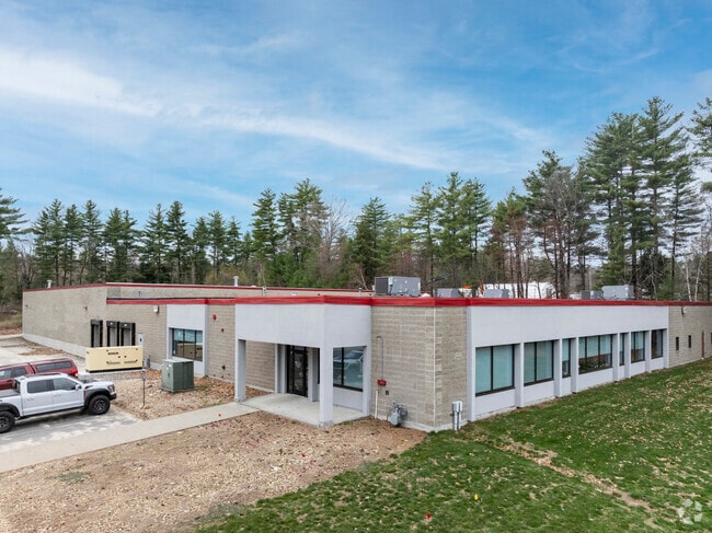
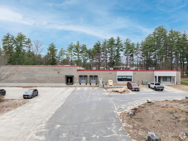
Property Detail
35 Scales Ln
TOWN-000018-000043-000002
Middlesex
Warehouse
Massachusetts
ID
2
B and X Area of moderate flood hazard, usually the area between the limits of the 100-year and 500-year floods.
10 AC
2025
Groton/Townsend
2025
Boston
301102
Boston-Cambridge-Newton, MA-NH
37,088 SF
NEARBY LISTINGS FOR SALE OR LEASE
-
-
View all Townsend listings for sale on LoopNet.com
DEMOGRAPHICS near 35 Scales Ln
1 mile
3 mile
5 mile
2025 Total Population
1,785
8,180
20,260
2030 Population
1,840
8,457
20,941
Pop Growth 2025-2030
+ 3.08%
+ 3.39%
+ 3.36%
Average Age
43
43
43
2025 Total Households
723
3,107
7,413
HH Growth 2025-2030
+ 3.04%
+ 3.41%
+ 3.40%
Median Household Inc
$105,156
$111,863
$120,074
Avg Household Size
2.50
2.60
2.70
2025 Avg HH Vehicles
2.00
2.00
2.00
Median Home Value
$409,664
$421,182
$454,848
Median Year Built
1973
1974
1976
Nearby Places
Map Layers
Map Styles
 Street
 Aerial
Layers
 Traffic
 Biking
Places
Listings with unknown addresses are not visible on the map
- Restaurants
- Banks
- Shops
- Fitness
- Groceries
PUBLIC TRANSPORTATION
COMMUTER RAIL
Fitchburg (Fitchburg/South Acton Line - Massachusetts Bay Transportation Authority Commuter Rail (Purple Line))
Drive
Walk
Distance
Fitchburg (Fitchburg/South Acton Line - Massachusetts Bay Transportation Authority Commuter Rail (Purple Line))
22 min
10.0 mi
AIRPORT
Manchester Boston Regional
Drive
Walk
Distance
Manchester Boston Regional
53 min
29.6 mi
Worcester Regional
Drive
Walk
Distance
Worcester Regional
61 min
38.2 mi
SALE & LEASE HISTORY
LISTING DATE
SALE/LEASE

Jun 10, 2020
For Sale
Jan 27, 2020
For Sale
Apr 19, 2018
For Sale
Apr 19, 2018
For Lease
Apr 19, 2018
For Sale
Apr 19, 2018
For Sale
Apr 16, 2020
For Lease
Nearby Properties
Address
Land Use
TOTAL SIZE
Lot Size
Zoning
Address
Land Use
TOTAL SIZE
Lot Size
Zoning
40.75 AC
RA3
Address
Land Use
TOTAL SIZE
Lot Size
Zoning
8.80 AC
Address
Land Use
TOTAL SIZE
Lot Size
Zoning
2,295.68 AC
RB2
Address
Land Use
TOTAL SIZE
Lot Size
Zoning
10,140 SF
12.50 AC
ID
Address
Land Use
TOTAL SIZE
Lot Size
Zoning
325,800 SF
16 AC
ID
Address
Land Use
TOTAL SIZE
Lot Size
Zoning
270,576 SF
11.50 AC
ID
Address
Land Use
TOTAL SIZE
Lot Size
Zoning
23,429 SF
8.01 AC
RA3
Address
Land Use
TOTAL SIZE
Lot Size
Zoning
40,180 SF
6.67 AC
RA3
Address
Land Use
TOTAL SIZE
Lot Size
Zoning
15,732 SF
1.20 AC
DCD
Address
Land Use
TOTAL SIZE
Lot Size
Zoning
116,014 SF
15 AC
ID
Address
Land Use
TOTAL SIZE
Lot Size
Zoning
33,758 SF
5.03 AC
RA3
Address
Land Use
TOTAL SIZE
Lot Size
Zoning
17,606 SF
0.91 AC
DCD
Address
Land Use
TOTAL SIZE
Lot Size
Zoning
9,677 SF
123.85 AC
ID
Address
Land Use
TOTAL SIZE
Lot Size
Zoning
483.42 AC
RA3
Address
Land Use
TOTAL SIZE
Lot Size
Zoning
90.70 AC
O
Address
Land Use
TOTAL SIZE
Lot Size
Zoning
6,432 SF
0.70 AC
DCD
Address
Land Use
TOTAL SIZE
Lot Size
Zoning
6,259 SF
2 AC
RA3
Address
Land Use
TOTAL SIZE
Lot Size
Zoning
280 AC
O
Address
Land Use
TOTAL SIZE
Lot Size
Zoning
Address
Land Use
TOTAL SIZE
Lot Size
Zoning
6 AC
NCD
Address
Land Use
TOTAL SIZE
Lot Size
Zoning
6,700 SF
1.54 AC
RA3
Address
Land Use
TOTAL SIZE
Lot Size
Zoning
48,420 SF
6.20 AC
ID
Address
Land Use
TOTAL SIZE
Lot Size
Zoning
2.71 AC
DCD
Address
Land Use
TOTAL SIZE
Lot Size
Zoning
23,447 SF
2.66 AC
OCD
Address
Land Use
TOTAL SIZE
Lot Size
Zoning
1,582 AC
RA3
Address
Land Use
TOTAL SIZE
Lot Size
Zoning
74 AC
RB2
Address
Land Use
TOTAL SIZE
Lot Size
Zoning
1.60 AC
DCD
Address
Land Use
TOTAL SIZE
Lot Size
Zoning
5,760 SF
0.57 AC
RA3
Address
Land Use
TOTAL SIZE
Lot Size
Zoning
7,547 SF
2.10 AC
RA3
The World's #1 Commercial Real Estate Marketplace
Connect with us
© 2026 CoStar Group
The information above has been obtained from sources believed reliable. While we do not doubt its accuracy we have not verified it and make no guarantee, warranty or representation about it. It is your responsibility to independently confirm its accuracy and completeness. Any projections, opinions, assumptions, or estimates used are for example only and do not represent the current or future performance of the property. The value of this transaction to you depends on tax and other factors which should be evaluated by your tax, financial, and legal advisors. You and your advisors should conduct a careful, independent investigation of the property to determine to your satisfaction the suitability of the property for your needs.