Property Record
35 State Rd, Phillipston, MA 01331
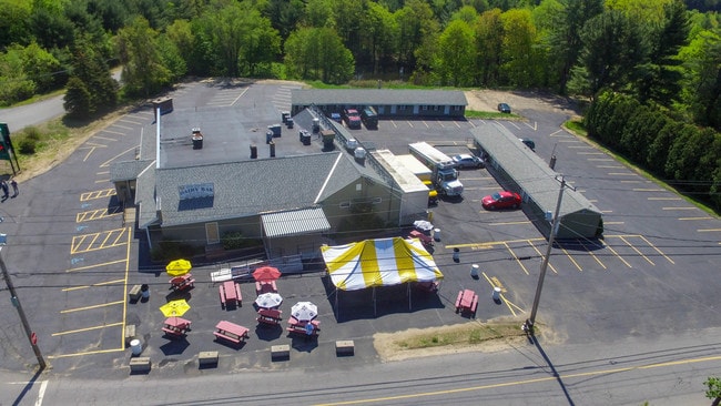


This Property Is For Sale
Property Detail
35 State Rd
Worcester, MA
Worcester
PHIL-000033-000000-000046
Massachusetts
Commercialnec
46
B
4.68 AC
2025
Massachusetts North/West Area
2025
Boston
704201
NEARBY LISTINGS FOR SALE OR LEASE
-
-
View all Phillipston listings for sale on LoopNet.com
DEMOGRAPHICS near 35 State Rd
1 mile
3 mile
5 mile
2025 Total Population
512
2,926
15,197
2030 Population
533
3,037
15,751
Pop Growth 2025-2030
+ 4.10%
+ 3.79%
+ 3.65%
Average Age
43
43
43
2025 Total Households
196
1,123
5,871
HH Growth 2025-2030
+ 4.59%
+ 3.92%
+ 3.78%
Median Household Inc
$98,570
$96,674
$86,828
Avg Household Size
2.60
2.60
2.50
2025 Avg HH Vehicles
2.00
2.00
2.00
Median Home Value
$403,191
$399,812
$347,101
Median Year Built
1984
1982
1972
Nearby Places
Map Layers
Map Styles
 Street
 Aerial
Layers
 Traffic
 Biking
Places
Listings with unknown addresses are not visible on the map
- Restaurants
- Banks
- Shops
- Fitness
- Groceries
PUBLIC TRANSPORTATION
AIRPORT
Worcester Regional
Drive
Walk
Distance
Worcester Regional
57 min
28.1 mi
Nearby Properties
Address
Land Use
TOTAL SIZE
Lot Size
Zoning
Address
Land Use
TOTAL SIZE
Lot Size
Zoning
76,943 SF
71.01 AC
Address
Land Use
TOTAL SIZE
Lot Size
Zoning
67,020 SF
8.93 AC
Address
Land Use
TOTAL SIZE
Lot Size
Zoning
25,840 SF
5.99 AC
Address
Land Use
TOTAL SIZE
Lot Size
Zoning
18,658 SF
2.50 AC
RA
Address
Land Use
TOTAL SIZE
Lot Size
Zoning
67.28 AC
B
Address
Land Use
TOTAL SIZE
Lot Size
Zoning
4,683 SF
9.88 AC
Address
Land Use
TOTAL SIZE
Lot Size
Zoning
6,484 SF
17 AC
Address
Land Use
TOTAL SIZE
Lot Size
Zoning
2,086 SF
1.44 AC
RC
Address
Land Use
TOTAL SIZE
Lot Size
Zoning
16,280 SF
7.20 AC
B
Address
Land Use
TOTAL SIZE
Lot Size
Zoning
7.01 AC
Address
Land Use
TOTAL SIZE
Lot Size
Zoning
7.68 AC
B
Address
Land Use
TOTAL SIZE
Lot Size
Zoning
19,172 SF
1.68 AC
Address
Land Use
TOTAL SIZE
Lot Size
Zoning
3,046 SF
4.15 AC
Address
Land Use
TOTAL SIZE
Lot Size
Zoning
6,148 SF
4.51 AC
B
Address
Land Use
TOTAL SIZE
Lot Size
Zoning
13,746 SF
6.32 AC
Address
Land Use
TOTAL SIZE
Lot Size
Zoning
3,244 SF
127.90 AC
Address
Land Use
TOTAL SIZE
Lot Size
Zoning
3,204 SF
29.55 AC
RA
Address
Land Use
TOTAL SIZE
Lot Size
Zoning
362.94 AC
Address
Land Use
TOTAL SIZE
Lot Size
Zoning
1,560 SF
64 AC
Address
Land Use
TOTAL SIZE
Lot Size
Zoning
13.01 AC
B
Address
Land Use
TOTAL SIZE
Lot Size
Zoning
864 SF
172.10 AC
Address
Land Use
TOTAL SIZE
Lot Size
Zoning
2,592 SF
Address
Land Use
TOTAL SIZE
Lot Size
Zoning
26.63 AC
Address
Land Use
TOTAL SIZE
Lot Size
Zoning
10.80 AC
Address
Land Use
TOTAL SIZE
Lot Size
Zoning
110.83 AC
RA
Address
Land Use
TOTAL SIZE
Lot Size
Zoning
291.77 AC
Address
Land Use
TOTAL SIZE
Lot Size
Zoning
4,288 SF
0.34 AC
RA
Address
Land Use
TOTAL SIZE
Lot Size
Zoning
42.40 AC
RA
Address
Land Use
TOTAL SIZE
Lot Size
Zoning
7,298 SF
3.40 AC
B
The World's #1 Commercial Real Estate Marketplace
Connect with us
© 2026 CoStar Group
The information above has been obtained from sources believed reliable. While we do not doubt its accuracy we have not verified it and make no guarantee, warranty or representation about it. It is your responsibility to independently confirm its accuracy and completeness. Any projections, opinions, assumptions, or estimates used are for example only and do not represent the current or future performance of the property. The value of this transaction to you depends on tax and other factors which should be evaluated by your tax, financial, and legal advisors. You and your advisors should conduct a careful, independent investigation of the property to determine to your satisfaction the suitability of the property for your needs.