Property Record
35 Wilcutt, Columbus, MS 39705
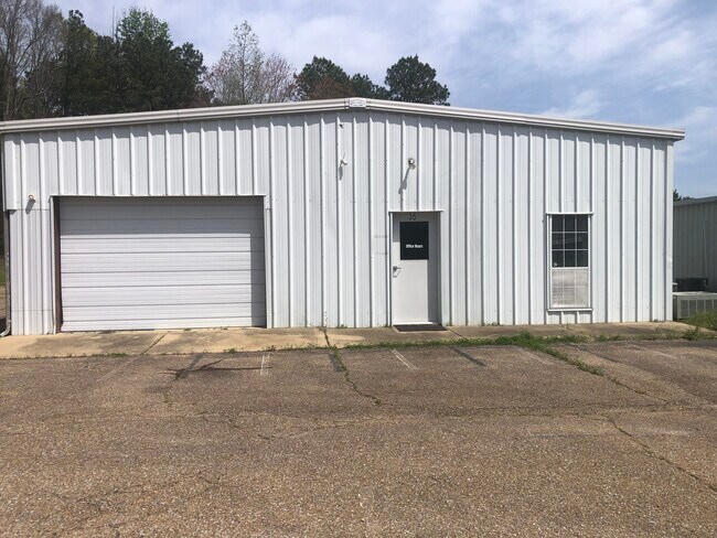
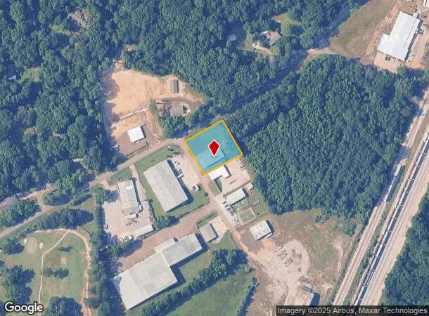
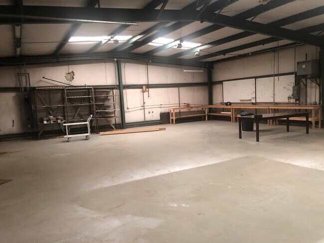
Property Detail
35 Wilcutt
Columbus, MS
PT SW4 35 WILLCUTT RD
55W09-00-01302
LOWNDES
Manufacturinglight
Mississippi
B and X Area of moderate flood hazard, usually the area between the limits of the 100-year and 500-year floods.
0.90 AC
2025
Vicksburg/Central Area
2025
Other Market Areas
000800
NEARBY LISTINGS FOR SALE OR LEASE
DEMOGRAPHICS near 35 Wilcutt
1 mile
3 mile
5 mile
2025 Total Population
1,092
22,573
32,055
2030 Population
1,064
22,165
31,485
Pop Growth 2025-2030
(2.56%)
(1.81%)
(1.78%)
Average Age
45
41
40
2025 Total Households
471
9,380
13,194
HH Growth 2025-2030
(2.55%)
(1.86%)
(1.79%)
Median Household Inc
$69,444
$43,809
$44,238
Avg Household Size
2.30
2.20
2.30
2025 Avg HH Vehicles
2.00
2.00
2.00
Median Home Value
$197,320
$153,748
$161,055
Median Year Built
1981
1976
1977
Nearby Places
Map Layers
Map Styles
 Street
 Aerial
Layers
 Traffic
 Biking
Places
Listings with unknown addresses are not visible on the map
- Restaurants
- Banks
- Shops
- Fitness
- Groceries
PUBLIC TRANSPORTATION
AIRPORT
Golden Triangle Regional
Drive
Walk
Distance
Golden Triangle Regional
26 min
15.4 mi
SALE & LEASE HISTORY
LISTING DATE
SALE/LEASE

Jul 14, 2025
For Sale
Nearby Properties
Address
Land Use
TOTAL SIZE
Lot Size
Zoning
Address
Land Use
TOTAL SIZE
Lot Size
Zoning
13,500 SF
12.20 AC
Address
Land Use
TOTAL SIZE
Lot Size
Zoning
210,798 SF
12.88 AC
Address
Land Use
TOTAL SIZE
Lot Size
Zoning
76,286 SF
0.02 AC
Address
Land Use
TOTAL SIZE
Lot Size
Zoning
38,000 SF
1.80 AC
Address
Land Use
TOTAL SIZE
Lot Size
Zoning
11,402 SF
30.30 AC
Address
Land Use
TOTAL SIZE
Lot Size
Zoning
16,589 SF
47.50 AC
Address
Land Use
TOTAL SIZE
Lot Size
Zoning
59,891 SF
9.30 AC
Address
Land Use
TOTAL SIZE
Lot Size
Zoning
134,799 SF
15.29 AC
Address
Land Use
TOTAL SIZE
Lot Size
Zoning
3,063 SF
10.19 AC
Address
Land Use
TOTAL SIZE
Lot Size
Zoning
60,623 SF
3.33 AC
Address
Land Use
TOTAL SIZE
Lot Size
Zoning
10,512 SF
1.31 AC
Address
Land Use
TOTAL SIZE
Lot Size
Zoning
5,400 SF
0.36 AC
Address
Land Use
TOTAL SIZE
Lot Size
Zoning
45,903 SF
2 AC
Address
Land Use
TOTAL SIZE
Lot Size
Zoning
47,304 SF
4.60 AC
Address
Land Use
TOTAL SIZE
Lot Size
Zoning
57,175 SF
3.03 AC
Address
Land Use
TOTAL SIZE
Lot Size
Zoning
40,929 SF
2.65 AC
Address
Land Use
TOTAL SIZE
Lot Size
Zoning
35,057 SF
1.83 AC
Address
Land Use
TOTAL SIZE
Lot Size
Zoning
2,703 SF
3 AC
Address
Land Use
TOTAL SIZE
Lot Size
Zoning
48,539 SF
0.02 AC
Address
Land Use
TOTAL SIZE
Lot Size
Zoning
4,000 SF
Address
Land Use
TOTAL SIZE
Lot Size
Zoning
1,795 SF
8.60 AC
Address
Land Use
TOTAL SIZE
Lot Size
Zoning
68,428 SF
8.70 AC
Address
Land Use
TOTAL SIZE
Lot Size
Zoning
6,290 SF
1 AC
Address
Land Use
TOTAL SIZE
Lot Size
Zoning
8,412 SF
7.10 AC
Address
Land Use
TOTAL SIZE
Lot Size
Zoning
103,842 SF
0.02 AC
Address
Land Use
TOTAL SIZE
Lot Size
Zoning
50,570 SF
2.50 AC
Address
Land Use
TOTAL SIZE
Lot Size
Zoning
12.20 AC
Address
Land Use
TOTAL SIZE
Lot Size
Zoning
86,498 SF
8.46 AC
Address
Land Use
TOTAL SIZE
Lot Size
Zoning
10,220 SF
3.70 AC
Address
Land Use
TOTAL SIZE
Lot Size
Zoning
12,092 SF
1.70 AC
The World's #1 Commercial Real Estate Marketplace
Connect with us
© 2026 CoStar Group
The information above has been obtained from sources believed reliable. While we do not doubt its accuracy we have not verified it and make no guarantee, warranty or representation about it. It is your responsibility to independently confirm its accuracy and completeness. Any projections, opinions, assumptions, or estimates used are for example only and do not represent the current or future performance of the property. The value of this transaction to you depends on tax and other factors which should be evaluated by your tax, financial, and legal advisors. You and your advisors should conduct a careful, independent investigation of the property to determine to your satisfaction the suitability of the property for your needs.