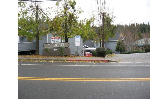
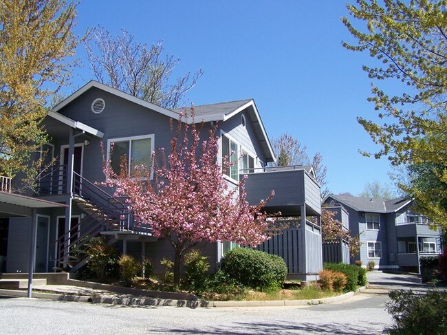
Property Record
350 Bennett St, Grass Valley, CA 95945

Save to a Folder
{{folder.Name}}
{{folder.ListingIds.length}} Properties
{{folder.ListingIds.length}} Property
Create a New Folder
Property Detail
350 Bennett St
Truckee-Grass Valley, CA
PTN LTS 3,4 BLK 16 EGV 26-16-8
009-262-011-000
Nevada
Multifamilydwelling
California
AE The base floodplain where base flood elevations are provided. AE Zones are now used on new format FIRMs instead of A1-A30 Zones.
3,4
2025
1.10 AC
2026
California North Rural Area
000602
Other Market Areas
19,776 SF
NEARBY LISTINGS FOR SALE OR LEASE
DEMOGRAPHICS near 350 Bennett St
1 mile
3 mile
5 mile
2025 Total Population
7,308
22,245
38,224
2030 Population
7,041
21,629
37,097
Pop Growth 2025-2030
(3.65%)
(2.77%)
(2.95%)
Average Age
45
47
48
2025 Total Households
3,332
9,657
16,547
HH Growth 2025-2030
(3.84%)
(2.86%)
(3.01%)
Median Household Inc
$49,782
$64,960
$70,551
Avg Household Size
2.00
2.10
2.20
2025 Avg HH Vehicles
2.00
2.00
2.00
Median Home Value
$503,483
$557,062
$596,955
Median Year Built
1970
1976
1977
Nearby Places
Map Layers
Map Styles
 Street
 Aerial
Layers
 Traffic
 Biking
Places
Listings with unknown addresses are not visible on the map
- Restaurants
- Banks
- Shops
- Fitness
- Groceries
Nearby Properties
Address
Land Use
TOTAL SIZE
Lot Size
Zoning
Address
Land Use
TOTAL SIZE
Lot Size
Zoning
Address
Land Use
TOTAL SIZE
Lot Size
Zoning
185,765 SF
26.56 AC
Address
Land Use
TOTAL SIZE
Lot Size
Zoning
145,522 SF
6.39 AC
Address
Land Use
TOTAL SIZE
Lot Size
Zoning
74,019 SF
4.20 AC
Address
Land Use
TOTAL SIZE
Lot Size
Zoning
56,318 SF
2.49 AC
Address
Land Use
TOTAL SIZE
Lot Size
Zoning
45,427 SF
4.06 AC
Address
Land Use
TOTAL SIZE
Lot Size
Zoning
45,263 SF
2.61 AC
Address
Land Use
TOTAL SIZE
Lot Size
Zoning
66,765 SF
7.21 AC
Address
Land Use
TOTAL SIZE
Lot Size
Zoning
11.47 AC
C2-SP
Address
Land Use
TOTAL SIZE
Lot Size
Zoning
34,128 SF
13.50 AC
Address
Land Use
TOTAL SIZE
Lot Size
Zoning
28,125 SF
7.12 AC
Address
Land Use
TOTAL SIZE
Lot Size
Zoning
48,000 SF
3.52 AC
Address
Land Use
TOTAL SIZE
Lot Size
Zoning
14,550 SF
1.95 AC
Address
Land Use
TOTAL SIZE
Lot Size
Zoning
41,500 SF
19.51 AC
RA-SP
Address
Land Use
TOTAL SIZE
Lot Size
Zoning
91,550 SF
6.67 AC
Address
Land Use
TOTAL SIZE
Lot Size
Zoning
Address
Land Use
TOTAL SIZE
Lot Size
Zoning
7.84 AC
Address
Land Use
TOTAL SIZE
Lot Size
Zoning
20.02 AC
OP
Address
Land Use
TOTAL SIZE
Lot Size
Zoning
21,505 SF
4.13 AC
Address
Land Use
TOTAL SIZE
Lot Size
Zoning
14,504 SF
2.21 AC
Address
Land Use
TOTAL SIZE
Lot Size
Zoning
87,696 SF
4.80 AC
Address
Land Use
TOTAL SIZE
Lot Size
Zoning
14,724 SF
4.87 AC
OP
Address
Land Use
TOTAL SIZE
Lot Size
Zoning
40,969 SF
3.48 AC
Address
Land Use
TOTAL SIZE
Lot Size
Zoning
65,468 SF
3.84 AC
Address
Land Use
TOTAL SIZE
Lot Size
Zoning
47,976 SF
4.52 AC
Address
Land Use
TOTAL SIZE
Lot Size
Zoning
41,130 SF
2.29 AC
Address
Land Use
TOTAL SIZE
Lot Size
Zoning
22,155 SF
2.77 AC
Address
Land Use
TOTAL SIZE
Lot Size
Zoning
33,642 SF
0.95 AC
Address
Land Use
TOTAL SIZE
Lot Size
Zoning
The World's #1 Commercial Real Estate Marketplace
Connect with us
© 2026 CoStar Group
The information above has been obtained from sources believed reliable. While we do not doubt its accuracy we have not verified it and make no guarantee, warranty or representation about it. It is your responsibility to independently confirm its accuracy and completeness. Any projections, opinions, assumptions, or estimates used are for example only and do not represent the current or future performance of the property. The value of this transaction to you depends on tax and other factors which should be evaluated by your tax, financial, and legal advisors. You and your advisors should conduct a careful, independent investigation of the property to determine to your satisfaction the suitability of the property for your needs.