Property Record
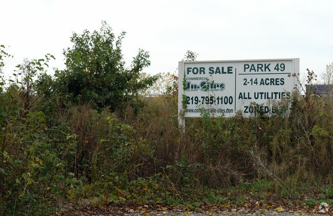
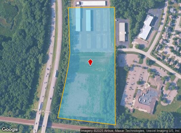
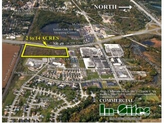
350 Council Rd, Chesterton, IN 46304
NEARBY LISTINGS FOR SALE OR LEASE
Property Detail
350 Council Rd
Chicago-Naperville-Elgin, IL-IN-WI
Maisels Chesterton Sub
64-04-31-326-002.000-023
MAISELS CHESTERTON SUB SLY PART OF LOT 5 DESC 12.448A TIF
Publicstorage
Porter
X
Indiana
18127C0131D
5
2023
44 SF
2024
Porter County
050202
Chicago
20,340 SF
DEMOGRAPHICS near 350 Council Rd
1 Mile
3 Mile
5 Mile
2024 Total Population
3,853
21,836
32,839
2029 Population
4,013
22,538
33,859
Pop Growth 2024-2029
+ 4.15%
+ 3.21%
+ 3.11%
Average Age
44
42
42
2024 Total Households
1,561
8,739
12,883
HH Growth 2024-2029
+ 4.16%
+ 3.23%
+ 3.14%
Median Household Inc
$95,386
$87,287
$89,590
Avg Household Size
2.40
2.40
2.50
2024 Avg HH Vehicles
2.00
2.00
2.00
Median Home Value
$286,770
$264,658
$275,156
Median Year Built
1977
1979
1986
Nearby Places
Map Layers
Map Styles
 Street
 Aerial
- Restaurants
- Banks
- Shops
- Fitness
- Groceries
PUBLIC TRANSPORTATION
COMMUTER RAIL
Dune Park (Chesterton) Station (South Shore Line - Northern Indiana Commuter Transportation District (South Shore Line))
DRIVE
WALK
Distance
Dune Park (Chesterton) Station (South Shore Line - Northern Indiana Commuter Transportation District (South Shore Line))
7 min
3.1 mi
Beverly Shores (South Shore Line - Northern Indiana Commuter Transportation District (South Shore Line))
DRIVE
WALK
Distance
Beverly Shores (South Shore Line - Northern Indiana Commuter Transportation District (South Shore Line))
13 min
6.8 mi
Freight Ports
Port Milwaukee
DRIVE
WALK
Distance
Port Milwaukee
167 min
133.6 mi
Nearby Properties
Address
Land Use
TOTAL SIZE
Lot Size
Zoning
Address
Land Use
TOTAL SIZE
Lot Size
Zoning
531,461 SF
174 SF
Address
Land Use
TOTAL SIZE
Lot Size
Zoning
189,071 SF
87 SF
Address
Land Use
TOTAL SIZE
Lot Size
Zoning
174,766 SF
87 SF
Address
Land Use
TOTAL SIZE
Lot Size
Zoning
109,131 SF
44 SF
Address
Land Use
TOTAL SIZE
Lot Size
Zoning
167,850 SF
46.39 AC
Address
Land Use
TOTAL SIZE
Lot Size
Zoning
61,120 SF
44 SF
Address
Land Use
TOTAL SIZE
Lot Size
Zoning
78,087 SF
44 SF
Address
Land Use
TOTAL SIZE
Lot Size
Zoning
108,528 SF
10.28 AC
Address
Land Use
TOTAL SIZE
Lot Size
Zoning
52,765 SF
5.92 AC
Address
Land Use
TOTAL SIZE
Lot Size
Zoning
61,873 SF
44 SF
Address
Land Use
TOTAL SIZE
Lot Size
Zoning
38,337 SF
44 SF
Address
Land Use
TOTAL SIZE
Lot Size
Zoning
114,061 SF
6.26 AC
Address
Land Use
TOTAL SIZE
Lot Size
Zoning
72,408 SF
2.75 AC
Address
Land Use
TOTAL SIZE
Lot Size
Zoning
62,401 SF
44 SF
Address
Land Use
TOTAL SIZE
Lot Size
Zoning
50,191 SF
2.43 AC
Address
Land Use
TOTAL SIZE
Lot Size
Zoning
60,861 SF
44 SF
Address
Land Use
TOTAL SIZE
Lot Size
Zoning
90,396 SF
6.82 AC
Address
Land Use
TOTAL SIZE
Lot Size
Zoning
63,357 SF
44 SF
Address
Land Use
TOTAL SIZE
Lot Size
Zoning
35,456 SF
7.88 AC
Address
Land Use
TOTAL SIZE
Lot Size
Zoning
62,261 SF
44 SF
Address
Land Use
TOTAL SIZE
Lot Size
Zoning
42.89 AC
Address
Land Use
TOTAL SIZE
Lot Size
Zoning
21,203 SF
131 SF
Address
Land Use
TOTAL SIZE
Lot Size
Zoning
20,400 SF
44 SF
Address
Land Use
TOTAL SIZE
Lot Size
Zoning
33,300 SF
1.97 AC
Address
Land Use
TOTAL SIZE
Lot Size
Zoning
11,978 SF
20 AC
Address
Land Use
TOTAL SIZE
Lot Size
Zoning
419,212 SF
78.36 AC
Address
Land Use
TOTAL SIZE
Lot Size
Zoning
36,288 SF
44 SF
Address
Land Use
TOTAL SIZE
Lot Size
Zoning
25,646 SF
2.57 AC
Address
Land Use
TOTAL SIZE
Lot Size
Zoning
36,288 SF
2.61 AC
Address
Land Use
TOTAL SIZE
Lot Size
Zoning
56,807 SF
44 SF
The World's #1 Commercial Real Estate Marketplace
Connect with us
© 2026 CoStar Group
The information above has been obtained from sources believed reliable. While we do not doubt its accuracy we have not verified it and make no guarantee, warranty or representation about it. It is your responsibility to independently confirm its accuracy and completeness. Any projections, opinions, assumptions, or estimates used are for example only and do not represent the current or future performance of the property. The value of this transaction to you depends on tax and other factors which should be evaluated by your tax, financial, and legal advisors. You and your advisors should conduct a careful, independent investigation of the property to determine to your satisfaction the suitability of the property for your needs.