Property Record
115 Cromer Rd, Lexington, SC 29073
This Property Is For Sale
NEARBY LISTINGS FOR SALE OR LEASE
Property Detail
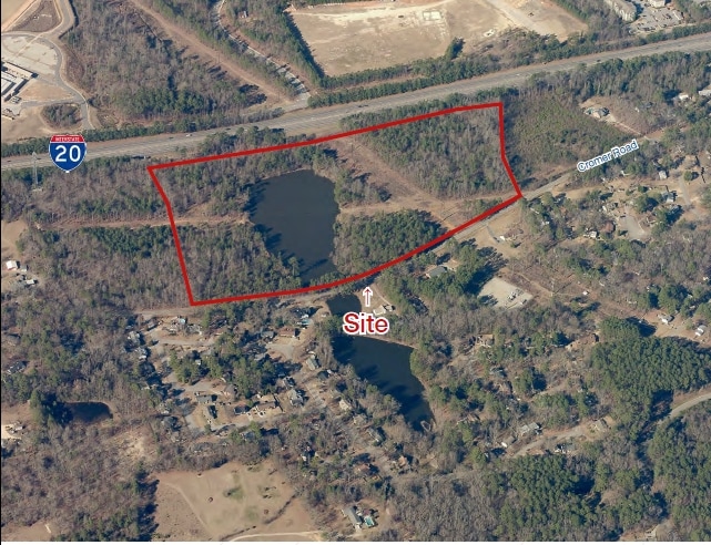
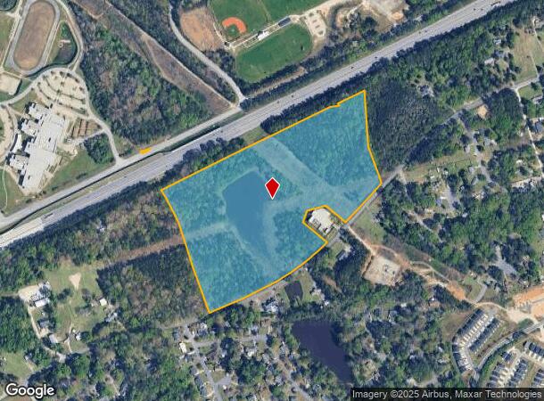
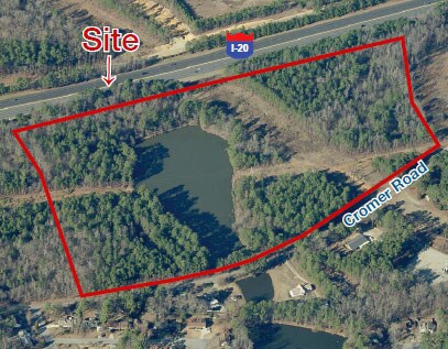
115 Cromer Rd
004497-03-002
PARCELS D & E
Commercialacreage
Lexington
A
South Carolina
45063C0143J
30.48 AC
2025
Cayce/West Columbia
2024
Columbia
021033
Columbia, SC
DEMOGRAPHICS near 115 Cromer Rd
1 Mile
3 Mile
5 Mile
2024 Total Population
3,920
35,008
119,238
2029 Population
4,248
38,072
127,920
Pop Growth 2024-2029
+ 8.37%
+ 8.75%
+ 7.28%
Average Age
37
40
40
2024 Total Households
1,475
14,161
48,950
HH Growth 2024-2029
+ 8.61%
+ 8.95%
+ 7.58%
Median Household Inc
$75,424
$69,751
$61,494
Avg Household Size
2.60
2.40
2.30
2024 Avg HH Vehicles
2.00
2.00
2.00
Median Home Value
$201,271
$193,195
$175,386
Median Year Built
1996
1992
1984
Nearby Places
Map Layers
Map Styles
 Street
 Aerial
- Restaurants
- Banks
- Shops
- Fitness
- Groceries
PUBLIC TRANSPORTATION
COMMUTER RAIL
Columbia Amtrak Station (Silver Star - Amtrak)
DRIVE
WALK
Distance
Columbia Amtrak Station (Silver Star - Amtrak)
15 min
7.3 mi
AIRPORT
Columbia Metro
DRIVE
WALK
Distance
Columbia Metro
23 min
10.6 mi
Freight Ports
North Charleston Terminal
DRIVE
WALK
Distance
North Charleston Terminal
123 min
106.8 mi
Nearby Properties
Address
Land Use
TOTAL SIZE
Lot Size
Zoning
Address
Land Use
TOTAL SIZE
Lot Size
Zoning
58,664 SF
6.01 AC
Address
Land Use
TOTAL SIZE
Lot Size
Zoning
8,330 SF
19.10 AC
ID
Address
Land Use
TOTAL SIZE
Lot Size
Zoning
63,658 SF
17.56 AC
GC
Address
Land Use
TOTAL SIZE
Lot Size
Zoning
3,080 SF
18.07 AC
R
Address
Land Use
TOTAL SIZE
Lot Size
Zoning
183,776 SF
18.23 AC
C2
Address
Land Use
TOTAL SIZE
Lot Size
Zoning
3,447 SF
10.03 AC
R3
Address
Land Use
TOTAL SIZE
Lot Size
Zoning
6,794 SF
6.17 AC
R1
Address
Land Use
TOTAL SIZE
Lot Size
Zoning
190,570 SF
10.01 AC
C2
Address
Land Use
TOTAL SIZE
Lot Size
Zoning
78,131 SF
24 AC
GC
Address
Land Use
TOTAL SIZE
Lot Size
Zoning
58.81 AC
RD
Address
Land Use
TOTAL SIZE
Lot Size
Zoning
99,628 SF
13.09 AC
RD
Address
Land Use
TOTAL SIZE
Lot Size
Zoning
153,351 SF
13.33 AC
RD
Address
Land Use
TOTAL SIZE
Lot Size
Zoning
2,065 SF
19.73 AC
HDR
Address
Land Use
TOTAL SIZE
Lot Size
Zoning
85,600 SF
22.08 AC
Address
Land Use
TOTAL SIZE
Lot Size
Zoning
7,383 SF
4.85 AC
ID
Address
Land Use
TOTAL SIZE
Lot Size
Zoning
59.61 AC
ID
Address
Land Use
TOTAL SIZE
Lot Size
Zoning
126,000 SF
8.89 AC
Address
Land Use
TOTAL SIZE
Lot Size
Zoning
8,876 SF
15.06 AC
R3
Address
Land Use
TOTAL SIZE
Lot Size
Zoning
10,616 SF
9.63 AC
R3
Address
Land Use
TOTAL SIZE
Lot Size
Zoning
3,825 SF
18.45 AC
RD
Address
Land Use
TOTAL SIZE
Lot Size
Zoning
127,329 SF
10.91 AC
Address
Land Use
TOTAL SIZE
Lot Size
Zoning
79,951 SF
3.31 AC
RD
Address
Land Use
TOTAL SIZE
Lot Size
Zoning
39,700 SF
73.29 AC
ID
Address
Land Use
TOTAL SIZE
Lot Size
Zoning
66,043 SF
2.70 AC
ID
Address
Land Use
TOTAL SIZE
Lot Size
Zoning
86,711 SF
3.46 AC
ID
Address
Land Use
TOTAL SIZE
Lot Size
Zoning
54,000 SF
8.60 AC
ID
Address
Land Use
TOTAL SIZE
Lot Size
Zoning
8,269 SF
12.99 AC
RD
Address
Land Use
TOTAL SIZE
Lot Size
Zoning
185,375 SF
10.76 AC
ID
Address
Land Use
TOTAL SIZE
Lot Size
Zoning
14,169 SF
6.46 AC
ID
Address
Land Use
TOTAL SIZE
Lot Size
Zoning
162,500 SF
12.36 AC
ID
The World's #1 Commercial Real Estate Marketplace
Connect with us
© 2026 CoStar Group
The information above has been obtained from sources believed reliable. While we do not doubt its accuracy we have not verified it and make no guarantee, warranty or representation about it. It is your responsibility to independently confirm its accuracy and completeness. Any projections, opinions, assumptions, or estimates used are for example only and do not represent the current or future performance of the property. The value of this transaction to you depends on tax and other factors which should be evaluated by your tax, financial, and legal advisors. You and your advisors should conduct a careful, independent investigation of the property to determine to your satisfaction the suitability of the property for your needs.