Property Record
350 Dennis Rd, Weatherford, TX 76087

Save to a Folder
{{folder.Name}}
{{folder.ListingIds.length}} Properties
{{folder.ListingIds.length}} Property
Create a New Folder
Property Detail
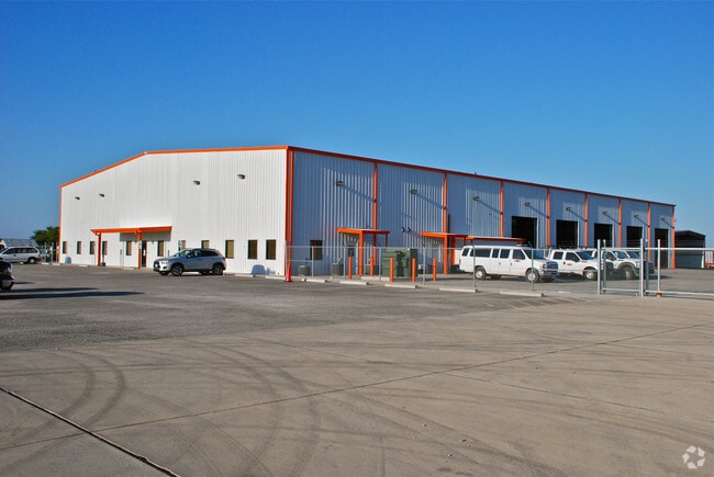
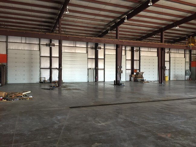
350 Dennis Rd
R000095298
ACRES: 11.655 ABST: 1658, SURV: J R WITT
Commercialnec
Parker
B and X Area of moderate flood hazard, usually the area between the limits of the 100-year and 500-year floods.
Texas
2024
11.66 AC
2025
Parker County
140601
Dallas/Ft Worth
27,852 SF
Dallas-Fort Worth-Arlington, TX
NEARBY LISTINGS FOR SALE OR LEASE
DEMOGRAPHICS near 350 Dennis Rd
1 mile
3 mile
5 mile
2025 Total Population
975
6,124
23,664
2030 Population
1,137
7,142
27,566
Pop Growth 2025-2030
+ 16.62%
+ 16.62%
+ 16.49%
Average Age
41
41
40
2025 Total Households
342
2,172
8,858
HH Growth 2025-2030
+ 15.79%
+ 15.79%
+ 15.71%
Median Household Inc
$130,555
$108,094
$89,175
Avg Household Size
2.80
2.80
2.60
2025 Avg HH Vehicles
2.00
2.00
2.00
Median Home Value
$523,649
$460,991
$360,491
Median Year Built
2004
2005
2000
Nearby Places
Map Layers
Map Styles
 Street
 Aerial
Layers
 Traffic
 Biking
Places
Listings with unknown addresses are not visible on the map
- Restaurants
- Banks
- Shops
- Fitness
- Groceries
SALE & LEASE HISTORY
LISTING DATE
SALE/LEASE

Dec 14, 2016
For Lease
Nearby Properties
Address
Land Use
TOTAL SIZE
Lot Size
Zoning
Address
Land Use
TOTAL SIZE
Lot Size
Zoning
44,831 SF
9.32 AC
Address
Land Use
TOTAL SIZE
Lot Size
Zoning
114,732 SF
6.78 AC
Address
Land Use
TOTAL SIZE
Lot Size
Zoning
27,760 SF
10.50 AC
Address
Land Use
TOTAL SIZE
Lot Size
Zoning
33,888 SF
5.65 AC
Address
Land Use
TOTAL SIZE
Lot Size
Zoning
27,500 SF
2.04 AC
Address
Land Use
TOTAL SIZE
Lot Size
Zoning
30,777 SF
8.25 AC
Address
Land Use
TOTAL SIZE
Lot Size
Zoning
14,500 SF
3.50 AC
Address
Land Use
TOTAL SIZE
Lot Size
Zoning
14,240 SF
2 AC
Address
Land Use
TOTAL SIZE
Lot Size
Zoning
18,858 SF
2 AC
Address
Land Use
TOTAL SIZE
Lot Size
Zoning
20,390 SF
10.31 AC
Address
Land Use
TOTAL SIZE
Lot Size
Zoning
18,892 SF
10.77 AC
Address
Land Use
TOTAL SIZE
Lot Size
Zoning
Address
Land Use
TOTAL SIZE
Lot Size
Zoning
19,720 SF
3.41 AC
Address
Land Use
TOTAL SIZE
Lot Size
Zoning
12,000 SF
4.25 AC
Address
Land Use
TOTAL SIZE
Lot Size
Zoning
20,000 SF
5.93 AC
Address
Land Use
TOTAL SIZE
Lot Size
Zoning
35,870 SF
5.96 AC
Address
Land Use
TOTAL SIZE
Lot Size
Zoning
Address
Land Use
TOTAL SIZE
Lot Size
Zoning
31,053 SF
4 AC
Address
Land Use
TOTAL SIZE
Lot Size
Zoning
6,500 SF
4.34 AC
Address
Land Use
TOTAL SIZE
Lot Size
Zoning
27,301 SF
3.30 AC
Address
Land Use
TOTAL SIZE
Lot Size
Zoning
7,320 SF
175.80 AC
Address
Land Use
TOTAL SIZE
Lot Size
Zoning
14,550 SF
5.50 AC
Address
Land Use
TOTAL SIZE
Lot Size
Zoning
15,929 SF
1.02 AC
Address
Land Use
TOTAL SIZE
Lot Size
Zoning
14,560 SF
5.53 AC
Address
Land Use
TOTAL SIZE
Lot Size
Zoning
17,730 SF
2 AC
Address
Land Use
TOTAL SIZE
Lot Size
Zoning
17,730 SF
3.88 AC
The World's #1 Commercial Real Estate Marketplace
Connect with us
© 2026 CoStar Group
The information above has been obtained from sources believed reliable. While we do not doubt its accuracy we have not verified it and make no guarantee, warranty or representation about it. It is your responsibility to independently confirm its accuracy and completeness. Any projections, opinions, assumptions, or estimates used are for example only and do not represent the current or future performance of the property. The value of this transaction to you depends on tax and other factors which should be evaluated by your tax, financial, and legal advisors. You and your advisors should conduct a careful, independent investigation of the property to determine to your satisfaction the suitability of the property for your needs.