Property Record
350 E St, Chula Vista, CA 91910
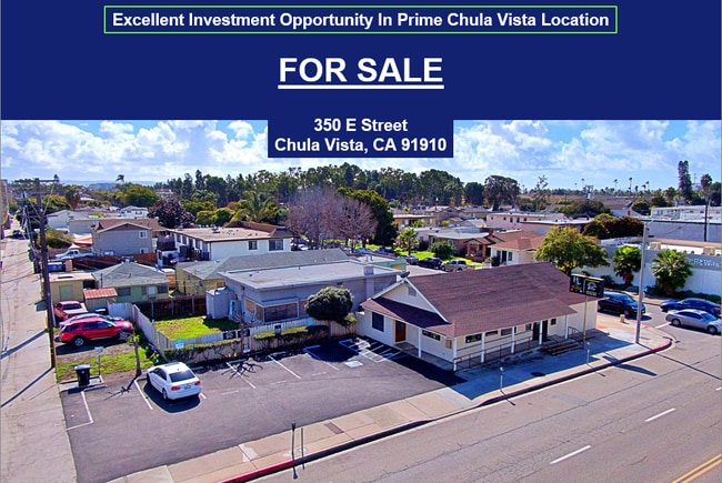

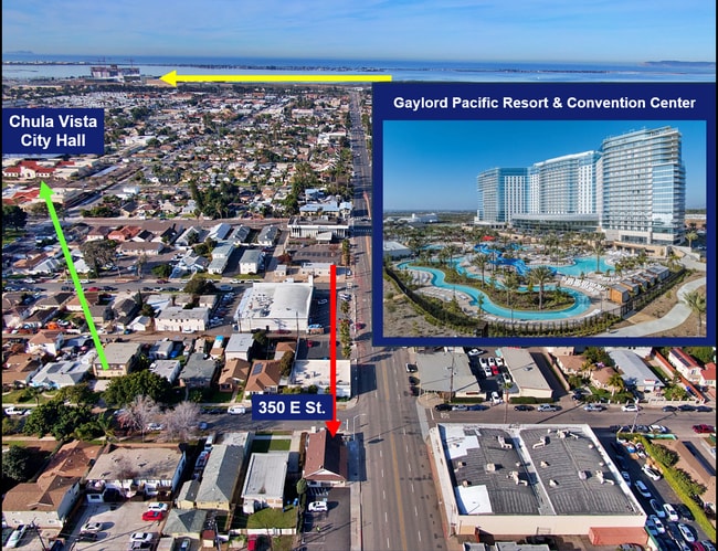

This Property Is For Sale
Property Detail
350 E St
568-043-01
BLK C LOT 1 TR 001197
Storesoffices
San Diego
V-3
California
B and X Area of moderate flood hazard, usually the area between the limits of the 100-year and 500-year floods.
1
2024
0.11 AC
2025
Chula Vista
012302
San Diego
1,512 SF
San Diego-Chula Vista-Carlsbad, CA
NEARBY LISTINGS FOR SALE OR LEASE
DEMOGRAPHICS near 350 E St
1 mile
3 mile
5 mile
2024 Total Population
33,379
166,199
429,731
2029 Population
33,641
166,197
429,430
Pop Growth 2024-2029
+ 0.78%
0.00%
(0.07%)
Average Age
39
39
38
2024 Total Households
11,985
52,435
126,359
HH Growth 2024-2029
+ 0.65%
(0.14%)
(0.21%)
Median Household Inc
$70,712
$77,133
$83,375
Avg Household Size
2.70
3.10
3.20
2024 Avg HH Vehicles
2.00
2.00
2.00
Median Home Value
$614,077
$700,256
$708,083
Median Year Built
1966
1966
1972
Nearby Places
Map Layers
Map Styles
 Street
 Aerial
Transit
 Traffic
 Biking
Places
Listings with unknown addresses are not visible on the map
- Restaurants
- Banks
- Shops
- Fitness
- Groceries
PUBLIC TRANSPORTATION
COMMUTER RAIL
San Diego (Santa Fe Depot) (Coaster - San Diego North County Transit District (Coaster/Sprinter/Breeze))
Drive
Walk
Distance
San Diego (Santa Fe Depot) (Coaster - San Diego North County Transit District (Coaster/Sprinter/Breeze))
14 min
9.2 mi
AIRPORT
San Diego International
Drive
Walk
Distance
San Diego International
17 min
11.7 mi
Freight Ports
Port of San Diego
Drive
Walk
Distance
Port of San Diego
13 min
7.6 mi
Nearby Properties
Address
Land Use
TOTAL SIZE
Lot Size
Zoning
Address
Land Use
TOTAL SIZE
Lot Size
Zoning
19.28 AC
60
Address
Land Use
TOTAL SIZE
Lot Size
Zoning
17.38 AC
UNZ
Address
Land Use
TOTAL SIZE
Lot Size
Zoning
11.42 AC
CP
Address
Land Use
TOTAL SIZE
Lot Size
Zoning
6.55 AC
MXD-2
Address
Land Use
TOTAL SIZE
Lot Size
Zoning
115.70 AC
Marine Ter
Address
Land Use
TOTAL SIZE
Lot Size
Zoning
24.70 AC
C-6
Address
Land Use
TOTAL SIZE
Lot Size
Zoning
9.62 AC
MXD-2
Address
Land Use
TOTAL SIZE
Lot Size
Zoning
25.35 AC
UC-7
Address
Land Use
TOTAL SIZE
Lot Size
Zoning
10.43 AC
RM-2
Address
Land Use
TOTAL SIZE
Lot Size
Zoning
8.79 AC
R3
Address
Land Use
TOTAL SIZE
Lot Size
Zoning
15 AC
UC-14
Address
Land Use
TOTAL SIZE
Lot Size
Zoning
9.84 AC
C
Address
Land Use
TOTAL SIZE
Lot Size
Zoning
24.06 AC
R3
Address
Land Use
TOTAL SIZE
Lot Size
Zoning
7.52 AC
MCR-2
Address
Land Use
TOTAL SIZE
Lot Size
Zoning
8.96 AC
UC-4
Address
Land Use
TOTAL SIZE
Lot Size
Zoning
6.03 AC
R3
Address
Land Use
TOTAL SIZE
Lot Size
Zoning
2.81 AC
IP
Address
Land Use
TOTAL SIZE
Lot Size
Zoning
34,200 SF
1.38 AC
CCPD-R
Address
Land Use
TOTAL SIZE
Lot Size
Zoning
6.85 AC
IL
Address
Land Use
TOTAL SIZE
Lot Size
Zoning
16,410 SF
UNZ
Address
Land Use
TOTAL SIZE
Lot Size
Zoning
6.07 AC
MXD-1
Address
Land Use
TOTAL SIZE
Lot Size
Zoning
4.80 AC
MXD-2
Address
Land Use
TOTAL SIZE
Lot Size
Zoning
Address
Land Use
TOTAL SIZE
Lot Size
Zoning
1.05 AC
C-1
Address
Land Use
TOTAL SIZE
Lot Size
Zoning
9.44 AC
PC
Address
Land Use
TOTAL SIZE
Lot Size
Zoning
0.68 AC
MXU
Address
Land Use
TOTAL SIZE
Lot Size
Zoning
1.43 AC
UC-2
Address
Land Use
TOTAL SIZE
Lot Size
Zoning
86,920 SF
2.38 AC
RM-2
Address
Land Use
TOTAL SIZE
Lot Size
Zoning
1.88 AC
UC-2
Address
Land Use
TOTAL SIZE
Lot Size
Zoning
2.24 AC
MXD-2
The World's #1 Commercial Real Estate Marketplace
Connect with us
© 2026 CoStar Group
The information above has been obtained from sources believed reliable. While we do not doubt its accuracy we have not verified it and make no guarantee, warranty or representation about it. It is your responsibility to independently confirm its accuracy and completeness. Any projections, opinions, assumptions, or estimates used are for example only and do not represent the current or future performance of the property. The value of this transaction to you depends on tax and other factors which should be evaluated by your tax, financial, and legal advisors. You and your advisors should conduct a careful, independent investigation of the property to determine to your satisfaction the suitability of the property for your needs.