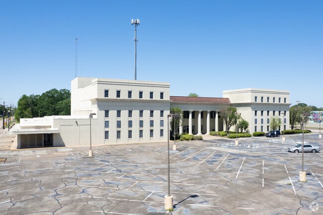
Property Record
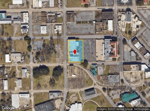
350 Magnolia St, Beaumont, TX 77701

This Property Is For Sale
NEARBY LISTINGS FOR SALE OR LEASE
Property Detail
350 Magnolia St
Beaumont/Port Arthur
Calder
Beaumont-Port Arthur, TX
LTS 5-12 & ADJ CLOSED ALLEY BLK 18 CALDER 1.377AC
008700-000-015000-00000
Jefferson
Commercialnec
Texas
2024
5-12
2025
1.38 AC
011700
Downtown Beaumont
59,291 SF
DEMOGRAPHICS near 350 Magnolia St
1 Mile
3 Mile
5 Mile
2024 Total Population
3,898
48,807
87,719
2029 Population
3,832
48,266
86,027
Pop Growth 2024-2029
(1.69%)
(1.11%)
(1.93%)
Average Age
38
38
38
2024 Total Households
1,416
18,684
34,539
HH Growth 2024-2029
(1.84%)
(1.16%)
(1.99%)
Median Household Inc
$48,631
$42,858
$47,890
Avg Household Size
2.40
2.50
2.40
2024 Avg HH Vehicles
1.00
2.00
2.00
Median Home Value
$90,819
$91,576
$135,195
Median Year Built
1965
1967
1974
Nearby Places
Map Layers
Map Styles
 Street
 Aerial
- Restaurants
- Banks
- Shops
- Fitness
- Groceries
PUBLIC TRANSPORTATION
COMMUTER RAIL
Beaumont Amtrak (Sunset Limited - Amtrak)
DRIVE
WALK
Distance
Beaumont Amtrak (Sunset Limited - Amtrak)
5 min
2.4 mi
Freight Ports
Port Beaumont
DRIVE
WALK
Distance
Port Beaumont
0 min
0.3 mi
Nearby Properties
Address
Land Use
TOTAL SIZE
Lot Size
Zoning
Address
Land Use
TOTAL SIZE
Lot Size
Zoning
373,397 SF
21.07 AC
Address
Land Use
TOTAL SIZE
Lot Size
Zoning
425,204 SF
6.99 AC
Address
Land Use
TOTAL SIZE
Lot Size
Zoning
163,287 SF
5.46 AC
Address
Land Use
TOTAL SIZE
Lot Size
Zoning
130,658 SF
8.03 AC
Address
Land Use
TOTAL SIZE
Lot Size
Zoning
2.07 AC
Address
Land Use
TOTAL SIZE
Lot Size
Zoning
241,242 SF
24.31 AC
Address
Land Use
TOTAL SIZE
Lot Size
Zoning
185,378 SF
2.76 AC
Address
Land Use
TOTAL SIZE
Lot Size
Zoning
56,223 SF
1.93 AC
Address
Land Use
TOTAL SIZE
Lot Size
Zoning
35,901 SF
2.71 AC
Address
Land Use
TOTAL SIZE
Lot Size
Zoning
250,157 SF
17.65 AC
Address
Land Use
TOTAL SIZE
Lot Size
Zoning
65,335 SF
11.51 AC
Address
Land Use
TOTAL SIZE
Lot Size
Zoning
61,010 SF
5.28 AC
Address
Land Use
TOTAL SIZE
Lot Size
Zoning
132,319 SF
13.24 AC
Address
Land Use
TOTAL SIZE
Lot Size
Zoning
124,838 SF
11.80 AC
Address
Land Use
TOTAL SIZE
Lot Size
Zoning
72,224 SF
1.46 AC
Address
Land Use
TOTAL SIZE
Lot Size
Zoning
101,083 SF
3.16 AC
Address
Land Use
TOTAL SIZE
Lot Size
Zoning
68,958 SF
1.78 AC
Address
Land Use
TOTAL SIZE
Lot Size
Zoning
75,288 SF
Address
Land Use
TOTAL SIZE
Lot Size
Zoning
70.66 AC
Address
Land Use
TOTAL SIZE
Lot Size
Zoning
76,000 SF
0.94 AC
Address
Land Use
TOTAL SIZE
Lot Size
Zoning
117,870 SF
4.04 AC
Address
Land Use
TOTAL SIZE
Lot Size
Zoning
43,095 SF
4.46 AC
Address
Land Use
TOTAL SIZE
Lot Size
Zoning
95,273 SF
9.43 AC
Address
Land Use
TOTAL SIZE
Lot Size
Zoning
191,420 SF
7.85 AC
Address
Land Use
TOTAL SIZE
Lot Size
Zoning
89,400 SF
4.20 AC
Address
Land Use
TOTAL SIZE
Lot Size
Zoning
113,667 SF
21.58 AC
Address
Land Use
TOTAL SIZE
Lot Size
Zoning
2.07 AC
Address
Land Use
TOTAL SIZE
Lot Size
Zoning
14,868 SF
1.90 AC
Address
Land Use
TOTAL SIZE
Lot Size
Zoning
127,949 SF
5.88 AC
Address
Land Use
TOTAL SIZE
Lot Size
Zoning
99,316 SF
5.07 AC
The World's #1 Commercial Real Estate Marketplace
Connect with us
© 2025 CoStar Group
The information above has been obtained from sources believed reliable. While we do not doubt its accuracy we have not verified it and make no guarantee, warranty or representation about it. It is your responsibility to independently confirm its accuracy and completeness. Any projections, opinions, assumptions, or estimates used are for example only and do not represent the current or future performance of the property. The value of this transaction to you depends on tax and other factors which should be evaluated by your tax, financial, and legal advisors. You and your advisors should conduct a careful, independent investigation of the property to determine to your satisfaction the suitability of the property for your needs.