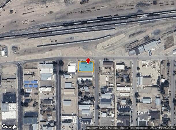
Property Record
350 N Kimball St, Casper, WY 82601
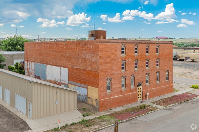
This Property Is For Sale
NEARBY LISTINGS FOR SALE OR LEASE
Property Detail
350 N Kimball St
Casper, WY
Casper
33-79-04-4-0-900100
CASPER BLK 58 LOT 24 & 50' TR ADJ ON S (AKA LOT 23) COMMERCIAL
Warehouse
Natrona
X
Wyoming
56025C2002E
24,50'
2024
0.33 AC
2025
I-25 Corridor/Casper
000200
Other Market Areas
22,500 SF
DEMOGRAPHICS near 350 N Kimball St
1 Mile
3 Mile
5 Mile
2024 Total Population
7,794
43,069
64,679
2029 Population
8,010
43,804
65,707
Pop Growth 2024-2029
+ 2.77%
+ 1.71%
+ 1.59%
Average Age
42
40
40
2024 Total Households
3,917
18,643
26,993
HH Growth 2024-2029
+ 2.71%
+ 1.73%
+ 1.63%
Median Household Inc
$36,373
$58,045
$62,318
Avg Household Size
1.90
2.20
2.30
2024 Avg HH Vehicles
2.00
2.00
2.00
Median Home Value
$168,371
$202,679
$229,691
Median Year Built
1948
1967
1974
Nearby Places
Map Layers
Map Styles
 Street
 Aerial
- Restaurants
- Banks
- Shops
- Fitness
- Groceries
PUBLIC TRANSPORTATION
AIRPORT
Casper/Natrona County International
DRIVE
WALK
Distance
Casper/Natrona County International
29 min
14.9 mi
Freight Ports
Tulsa Port Of Catoosa
DRIVE
WALK
Distance
Tulsa Port Of Catoosa
992 min
977.5 mi
Nearby Properties
Address
Land Use
TOTAL SIZE
Lot Size
Zoning
Address
Land Use
TOTAL SIZE
Lot Size
Zoning
12,674 SF
13.26 AC
Address
Land Use
TOTAL SIZE
Lot Size
Zoning
4,384 SF
13.74 AC
Address
Land Use
TOTAL SIZE
Lot Size
Zoning
156,457 SF
5.74 AC
Address
Land Use
TOTAL SIZE
Lot Size
Zoning
102,996 SF
4.81 AC
Address
Land Use
TOTAL SIZE
Lot Size
Zoning
53,685 SF
4.28 AC
Address
Land Use
TOTAL SIZE
Lot Size
Zoning
16,924 SF
9.54 AC
Address
Land Use
TOTAL SIZE
Lot Size
Zoning
95,290 SF
0.57 AC
Address
Land Use
TOTAL SIZE
Lot Size
Zoning
99,524 SF
4.67 AC
Address
Land Use
TOTAL SIZE
Lot Size
Zoning
81,240 SF
5.86 AC
Address
Land Use
TOTAL SIZE
Lot Size
Zoning
585,921 SF
58.85 AC
Address
Land Use
TOTAL SIZE
Lot Size
Zoning
166,099 SF
7.65 AC
Address
Land Use
TOTAL SIZE
Lot Size
Zoning
89,892 SF
2.75 AC
Address
Land Use
TOTAL SIZE
Lot Size
Zoning
10,928 SF
6.90 AC
Address
Land Use
TOTAL SIZE
Lot Size
Zoning
206,796 SF
18.06 AC
Address
Land Use
TOTAL SIZE
Lot Size
Zoning
89,995 SF
6.68 AC
Address
Land Use
TOTAL SIZE
Lot Size
Zoning
88,739 SF
13.39 AC
Address
Land Use
TOTAL SIZE
Lot Size
Zoning
54,112 SF
3.52 AC
Address
Land Use
TOTAL SIZE
Lot Size
Zoning
40,414 SF
0.03 AC
Address
Land Use
TOTAL SIZE
Lot Size
Zoning
36,379 SF
4.02 AC
Address
Land Use
TOTAL SIZE
Lot Size
Zoning
70,772 SF
11.68 AC
Address
Land Use
TOTAL SIZE
Lot Size
Zoning
110,360 SF
12.85 AC
Address
Land Use
TOTAL SIZE
Lot Size
Zoning
92,078 SF
5.52 AC
Address
Land Use
TOTAL SIZE
Lot Size
Zoning
21,120 SF
16.73 AC
Address
Land Use
TOTAL SIZE
Lot Size
Zoning
24,240 SF
16.47 AC
Address
Land Use
TOTAL SIZE
Lot Size
Zoning
29,040 SF
5.35 AC
Address
Land Use
TOTAL SIZE
Lot Size
Zoning
82,800 SF
5.94 AC
Address
Land Use
TOTAL SIZE
Lot Size
Zoning
119,046 SF
12.71 AC
Address
Land Use
TOTAL SIZE
Lot Size
Zoning
57,037 SF
1.01 AC
Address
Land Use
TOTAL SIZE
Lot Size
Zoning
45,140 SF
7.84 AC
Address
Land Use
TOTAL SIZE
Lot Size
Zoning
1,938 SF
7.71 AC
The World's #1 Commercial Real Estate Marketplace
Connect with us
© 2025 CoStar Group
The information above has been obtained from sources believed reliable. While we do not doubt its accuracy we have not verified it and make no guarantee, warranty or representation about it. It is your responsibility to independently confirm its accuracy and completeness. Any projections, opinions, assumptions, or estimates used are for example only and do not represent the current or future performance of the property. The value of this transaction to you depends on tax and other factors which should be evaluated by your tax, financial, and legal advisors. You and your advisors should conduct a careful, independent investigation of the property to determine to your satisfaction the suitability of the property for your needs.