Property Record
350 Newport Bridge Rd, Pine Island, NY 10969
NEARBY LISTINGS FOR SALE OR LEASE
-
-
View all Pine Island listings for sale on LoopNet.com
Property Detail
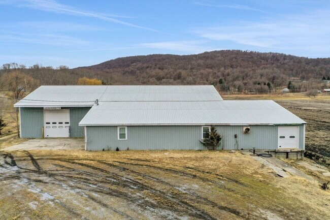
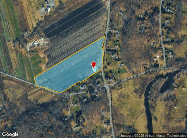
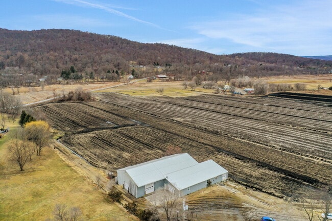
350 Newport Bridge Rd
335489-010-000-0001-036.000-0000
Orange
Warehouse
New York
A
36.00
34037C0090E
15.60 AC
2024
Orange County
2024
Northern New Jersey
014501
New York-Jersey City-White Plains, NY-NJ
7,600 SF
DEMOGRAPHICS near 350 Newport Bridge Rd
1 Mile
3 Mile
5 Mile
2024 Total Population
549
4,834
15,544
2029 Population
575
5,106
16,562
Pop Growth 2024-2029
+ 4.74%
+ 5.63%
+ 6.55%
Average Age
42
42
42
2024 Total Households
192
1,708
5,517
HH Growth 2024-2029
+ 4.69%
+ 5.74%
+ 6.74%
Median Household Inc
$137,228
$133,225
$126,175
Avg Household Size
2.80
2.80
2.80
2024 Avg HH Vehicles
3.00
3.00
2.00
Median Home Value
$438,043
$367,924
$368,391
Median Year Built
1975
1976
1976
Nearby Places
Map Layers
Map Styles
 Street
 Aerial
- Restaurants
- Banks
- Shops
- Fitness
- Groceries
PUBLIC TRANSPORTATION
AIRPORT
New York Stewart International
DRIVE
WALK
Distance
New York Stewart International
53 min
28.5 mi
Freight Ports
Maher Terminal
DRIVE
WALK
Distance
Maher Terminal
87 min
56.9 mi
SALE & LEASE HISTORY
LISTING DATE
SALE/LEASE

Apr 10, 2025
For Sale
Nearby Properties
Address
Land Use
TOTAL SIZE
Lot Size
Zoning
Address
Land Use
TOTAL SIZE
Lot Size
Zoning
254,440 SF
65 AC
P
Address
Land Use
TOTAL SIZE
Lot Size
Zoning
1,002 SF
152.70 AC
R1
Address
Land Use
TOTAL SIZE
Lot Size
Zoning
274 AC
Address
Land Use
TOTAL SIZE
Lot Size
Zoning
5,309 SF
3 AC
Address
Land Use
TOTAL SIZE
Lot Size
Zoning
227.29 AC
P
Address
Land Use
TOTAL SIZE
Lot Size
Zoning
74.46 AC
P
Address
Land Use
TOTAL SIZE
Lot Size
Zoning
7,690 SF
2.56 AC
R1
Address
Land Use
TOTAL SIZE
Lot Size
Zoning
3,196 SF
9.36 AC
R2
Address
Land Use
TOTAL SIZE
Lot Size
Zoning
55.85 AC
P
Address
Land Use
TOTAL SIZE
Lot Size
Zoning
3,998 SF
1.80 AC
C1
Address
Land Use
TOTAL SIZE
Lot Size
Zoning
2,716 SF
1.25 AC
Address
Land Use
TOTAL SIZE
Lot Size
Zoning
1,957 SF
31.44 AC
Address
Land Use
TOTAL SIZE
Lot Size
Zoning
3,375 SF
1 AC
Address
Land Use
TOTAL SIZE
Lot Size
Zoning
2,862 SF
1.28 AC
R1
Address
Land Use
TOTAL SIZE
Lot Size
Zoning
3,840 SF
3.84 AC
R1
Address
Land Use
TOTAL SIZE
Lot Size
Zoning
5,880 SF
260.40 AC
CONF
Address
Land Use
TOTAL SIZE
Lot Size
Zoning
50 AC
R1
Address
Land Use
TOTAL SIZE
Lot Size
Zoning
64.02 AC
Address
Land Use
TOTAL SIZE
Lot Size
Zoning
35.07 AC
R-2
Address
Land Use
TOTAL SIZE
Lot Size
Zoning
2,368 SF
96.81 AC
P
Address
Land Use
TOTAL SIZE
Lot Size
Zoning
2,724 SF
1 AC
Address
Land Use
TOTAL SIZE
Lot Size
Zoning
2,500 SF
3.28 AC
Address
Land Use
TOTAL SIZE
Lot Size
Zoning
95.99 AC
P
Address
Land Use
TOTAL SIZE
Lot Size
Zoning
3,675 SF
1.50 AC
Address
Land Use
TOTAL SIZE
Lot Size
Zoning
21.25 AC
R2
Address
Land Use
TOTAL SIZE
Lot Size
Zoning
25.36 AC
R1
Address
Land Use
TOTAL SIZE
Lot Size
Zoning
3,590 SF
1 AC
Address
Land Use
TOTAL SIZE
Lot Size
Zoning
120.53 AC
P
Address
Land Use
TOTAL SIZE
Lot Size
Zoning
26.85 AC
R2
Address
Land Use
TOTAL SIZE
Lot Size
Zoning
2,936 SF
2 AC
AET
The World's #1 Commercial Real Estate Marketplace
Connect with us
© 2025 CoStar Group
The information above has been obtained from sources believed reliable. While we do not doubt its accuracy we have not verified it and make no guarantee, warranty or representation about it. It is your responsibility to independently confirm its accuracy and completeness. Any projections, opinions, assumptions, or estimates used are for example only and do not represent the current or future performance of the property. The value of this transaction to you depends on tax and other factors which should be evaluated by your tax, financial, and legal advisors. You and your advisors should conduct a careful, independent investigation of the property to determine to your satisfaction the suitability of the property for your needs.